 |
|
Guangdong map
|
China has a long tradition of historical studies in general and geographical studies in particular. However, Hoang Sa (Paracel) and Truong Sa (Spratly) Islands have never appeared in ancient administrative maps of China.
VietNamNet introduces extracts from the book "Vietnamese sovereignty over Hoang Sa and Truong Sa Islands" by Assoc. Prof. Dr. Truong Minh Duc.
The first complete map representing China’s border is said to be made in 1121 (Song dynasty). This map, carved on stone, was discovered in 1960 in Sichuan province of China.
On this map, the Song Dynasty’s southernmost point is Hainan Island. The shape of Hainan Island in the lower left corner of this map is drawn quite accurately, similar to the shape of Hainan Island on the modern maps.
 |
| Hoang Sa and Truong Sa have never appeared in China's ancient administrative maps |
The maps made later, such as the united national map of the Ming Dynasty (1461); the map by La Hong Tien, which was completed in 1541 and engraved in 1555; the map that was printed in 1636; and the map by Yangzi in 1526, which were made in accordance with the policy of the central government as national administrative maps, show that China's southernmost point is Hainan Island.
Under the Qing Dynasty, the map printed by the royal court in 1894 also shows that Chinese territory to the south ends at Hainan Island.
Another map called the map of Great Qing, issued by the Qing Dynasty, did not draw the archipelagoes of Hoang Sa and Truong Sa.
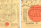
The map called the Complete Map of Great Qing, which is now preserved at the National Library of Australia, is the most complete map of modern China. The whole map includes 21 parts.
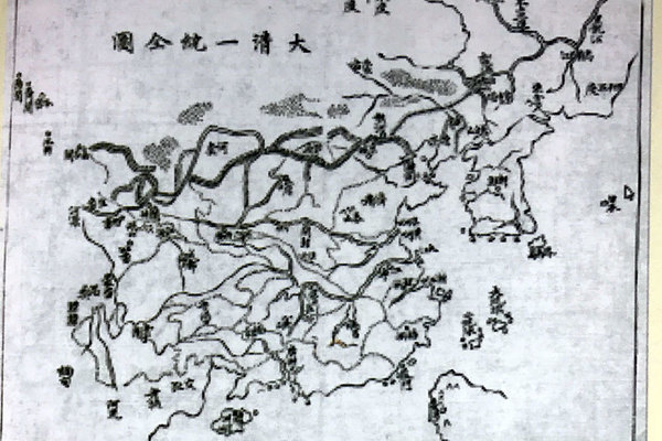 |
| The Complete Map of Great Qing |
Part 1 is a general map of China during the Qing Dynasty, with the islands as follows:
Feng Ma Island: south of Korea
Dai Luu Cau, Tieu Lau Cau: the eastern part of Zhejiang province
Taiwan: east of Fujian province
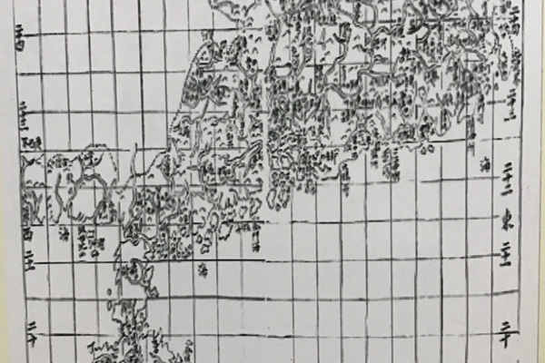
Kunzhou and Zhouzhou (belonging to Hainan Island): located in the southern mainland of Guangdong province.
Part 12: Guangdong map, showing the southern contiguity of Guangdong mainland is Hainan Island and some adjacent islands, without any other islands to the south of Hainan.
Most of the places on the map are mentioned in the Qing Dynasty History Book. This is the Chinese history book that was compiled in 10 years, starting from 1914. Notably, the content of the map and the book are similar.
The authors of Guangdong map and Qing Dynasty History Book did not show on the map and wrote no words or lines describing the Hoang Sa and Truong Sa Islands.
In research works about Nanhai, Chinese scholars often use about 50 maps made in the Ming and Qing dynasties - the world overview maps - to argue about historical sovereignty of China over the two archipelagos of Xisha and Nansha (the way they call Truong Sa and Hoang Sa of Vietnam).
Meanwhile, the ancient maps showing the border of old China (as valuable as today's Chinese administrative maps), which are the legal basis for determining national sovereignty, did not mention Truong Sa and Hoang Sa.
Recently, collectors discovered that three volumes of atlas published by the Chinese government did not show China's sovereignty over the Hoang Sa and Truong Sa Islands.
They are: Atlas of the Chinese Empire published in 1908 in English; Atlas Postal de Chine published by the General Department of Post and Telecommunications of the People's Republic of China in Nanjing in 1919; and Atlas Postal de also published by the General Department of Post and Telecommunications of the People's Republic of China in Nanjing in 1933.
 |
|
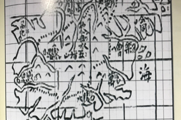
Hainan Island in Guangdong, complete map and notes of places.
|
The atlases were the product of a postal mapping program designed by the Qing Dynasty in 1906 and succeeded by the Chinese government in the following years.
The places that do not belong to Chinese territory are not shown on maps in the atlas. China's southernmost tip in these atlases is always Hainan Island, with no mention of Vietnam’s Hoang Sa (Paracel) and Truong Sa (Spratly) Islands.
This proves that when the Qing Dynasty released these atlases in 1906 and later the Chinese government republished these atlases in 1919 and 1933, Vietnam’s Hoang Sa and Truong Sa (Paracel and Spratly Islands) were still outside the illegal Chinese so-called "historical sovereignty".
Truong Minh Duc (Ho Chi Minh National Academy of Politics)

Chinese coastguard ships ‘deliberately visible' in the East Sea
Some Chinese coastguard vessels deployed in the East Sea have deliberately made themselves visible to rival claimants of the contested waters by turning on tracking signals – a move analysts described as an attempt to assert sovereignty.
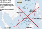
Operations of Chinese vessels are against agreements between Chinese and Vietnamese leaders
The activities of Chinese vessels in Vietnam's waters have seriously violated international law and gone against agreements reached between senior leaders of the two countries.
Ancient Chinese books say Hoang Sa, Truong Sa belong to Vietnam
Many ancient Chinese bibliographies, recorded by the Chinese themselves, directly or indirectly, recognize Vietnam’s sovereignty over the two archipelagos of Hoang Sa (Paracel Islands) and Truong Sa (Spratly Islands).