 |
| A map showing the direction of Typhoon Kammuri – PHOTO: NATIONAL CENTER FOR HYDRO-METEOROLOGICAL FORECASTING |
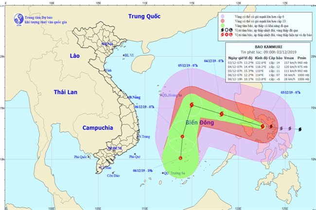
As of 7 a.m. today, December 3, the storm was centered in the Philippines’ central region, with gale-force winds blowing at 135-165 kilometers per hour, gusting at level 17, according to the National Center for Hydro-Meteorological Forecasting.
The storm is expected to move west-northwest at 15-20 kilometers per hour and enter the East Sea in the next 24 hours.
The system may be some 550 kilometers northeast of Song Tu Tay Island of the Truong Sa Archipelago by 7 a.m. on November 4, gusting at level 15.
In the next 24-48 hours, Kammuri will continue its west-northwest drift at 15 kilometers per hour.
By 7 a.m. on November 5, the storm is predicted to be some 450 kilometers north of Song Tu Tay Island, with maximum winds blowing at 115 kilometers per hour, gusting at level 14.
Kammuri may weaken into a tropical depression in the next 48-72 hours after it changes direction toward the southwest at 10-15 kilometers per hour.
The tropical system will possibly be located approximately 130 kilometers north-northwest of Song Tu Tay Island at 7 a.m. on November 6 and may be further downgraded into a tropical low in the next 72-96 hours.
Besides this, gusting northeast winds at level 9 and rough seas may occur in the north, central and southwest of the East Sea, including the Hoang Sa (Paracel) and Truong Sa (Spratly) archipelagos, due to the impact of a cold air mass.
Coastal areas running from Quang Tri to Ca Mau could experience strong northeast winds at level 6, in addition to rough seas. SGT