 |
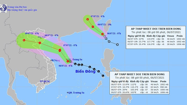
| Projected location and movement of the two tropical depressions. (Photo: nchmf.gov.vn) |
The reported tropical depression was spotted at about 15.8 degrees north latitude and 112.5 degrees east longitude at 4 am this morning, packing strongest wind at 39-49 km/h.
In the next 24 hours, it is likely to move north-westward at about 10 km per hour and strengthen into a storm.
In the next 24 to 48 hours, the storm continues to move in the northwest direction, traveling 15-20 km per hour. At 4 am on July 8, the storm is forecast to hit the Gulf of Tonkin, with the strongest wind at 62-74 km/h.
In the next 48 to 72 hours, the storm moves in the northwest direction, traveling about 15 km per hour and gradually weakening into a tropical depression.
Ships operating in the affected areas of the tropical depression are warned of strong wind and rough sea that may occur in most parts of the East Sea.
In addition, a new tropical depression entered the north-eastern part of the East Sea early this morning.
It is forecasted that in the next 12 hours, the tropical depression will move to the northwest, going 25-30km per hour. At 7 pm on July 6, the tropical depression is on the coast of Fujian province (China), with the strongest wind blowing at 39-49km/h.
In the next 12 to 24 hours, the tropical depression moves in the north-northwest direction, about 25km per hour, going deep inland and gradually weakening into a low pressure area.
Source: Nhan Dan

Up to six storms to hit mainland this year: meteorologist
About 12-14 storms could hit the East Sea this year, with around half expected to directly affect Vietnam’s mainland, a meteorologist has said.