 |
| Architect Dao Ngoc Nghiem. — Photo hanoimoi.com.vn |
When did the study planning the Hong (Red) River banks start?
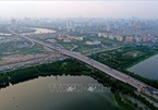
The portion of the Red River that runs through Hanoi has a total length of about 130km. For ages, people have lived on both sides of the Red River. In the 1998 Hanoi’s master development plan, city authorities adopted a decision to develop the city along the banks of the Red River, in which the Red River would become an axis in the city’s course of urban development.
To implement the Prime Minister’s Decision 1259, in 2012, Hanoi authorities approved the planning design for areas along the two sides of the Red River. And in the last three years, the Hanoi Construction Planning Institute has developed a planning map for the development of the Red River. However, until now such an architectural design and other ideas on the development plan of the Red River banks remain on paper.
Why? What has caused the delay for the approval of the plan?
A very important requirement in the planning of the Red River banks is to develop an important axis space for Hanoi to ensure urban areas continue to develop, yet still make the best use of available land and protect Hanoi’s inner city from flooding.
However, the idea of developing the land outside of the river dyke must adhere to the Vietnamese 2006 Law on Dyke Management and the Government Decree 113 which was issued on June 28, 2007 on the master planning of dykes along the Red River and the Thai Binh River. However, until now Hanoi and Thai Binh authorities have not yet got their master plan on anti-flood ready for the Ministry of Agriculture and Rural Development to approve. That’s why the plan on zoning the Red River remains on paper.
Can you explain more about the development plan for the two sides of the Red River?
By now there are quite a few proposals on the planning of the Red River at different scopes and scales. For example, in 1996, a Singaporean investor came up with a proposal to develop a big and modern urban area in An Duong area which is located on one side of the Red River dyke. According to the Singaporean proposal, the area would be modelled on an urban area in Singapore. Then in 2005, American Indochina Land Corporation came up with a proposal to build a science hub in the An Duong area.
In 2004, another project which was named HAIDEP – a joint venture between Vietnam and Japan, also came up with a proposal to build cities along the banks of the Red River.
In 2006, Hanoi and Seoul authorities signed a mutual agreement on co-operation in the development of the River dyke portion which run through Hanoi.
In 2017, quite a few big Vietnamese economic groups, including Sun Group, Vingroup and Geleximco and others also came up with proposals to financially sponsor the planning study, particularly the harness of the Red River and the transportation activities along the Red River. Adding to that, Hanoi authorities have also adopted a plan to assign the Hanoi Institute of Construction and Planning to work with Sun Group, Vingroup and Geleximco to study developing urban areas along a portion of the Red River which runs through Hanoi.
What are the challenges in the development of the portion of the Red River which runs through Hanoi?
The biggest challenge is how to calculate the stability of the flood diversion and the dyke system for Hanoi. To do that the Ministry of Agriculture and Rural Development should develop a plan on the flood discharge for the Red River as well as the whole dyke system that runs through Hanoi.
Furthermore, Hanoi should adopt a detailed plan on the development of the banks of the Red River. And of course, to do that Hanoi should also adopt a preferential policy to turn ideas into life. VNS
Hanoi rekindles riverside megacity project along the Red River
Hanoi seeks ideas to develop Red River banks
RoK to help Hanoi plan development
Vietnam's regional zoning to be changed
Vietnam is thinking about renewing its regional zoning through dividing the north-central and central coastal region into two new regions: north-central region and south-central region.