 |
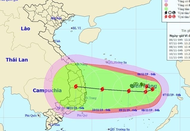
Early on the morning of November 6, the eye of the storm was forecast to be 310km north-northeast of Vietnam’s Song Tu Tay Island under Truong Sa (Spratly) Archipelago, with the strongest winds near the storm’s eye expected to reach level 8-10.
Over the next 24 hours, the storm will move slowly to the east at a speed of 5km per hour and is likely to become stronger. At dawn on November 7, the eye of the storm could be 330km northeast of Song Tu Tay Island with wind power increasing to level 9 - 11.
In the following hours, the storm is forecast to maintain its speed and move slowly to the south, then it will change its direction to the west and continue to strengthen its power.
On the morning of November 8, the storm’s eye is predicted to be about 280km northeast of Song Tu Tay Island with the strongest winds at level 10-12.
According to the National Centre for Hydro-Meteorological Forecasting (NCHMF), the storm will likely be 180km north of Song Tu Tay Island, with strongest winds up to level 11-13, on November 9.
In the next 72 to 120 hours, the storm will continue moving west with increased speed.
Provinces from Thua Thien – Hue to Vung Tau are anticipated to be affected by the storm. Nhan Dan
Tropical depression forecast to develop into new storm
The reported low-pressure area in the East Sea is strengthening its power and likely to develop into a new storm in the next 24 hours, as forecast by the national weather service.