 |
|
|
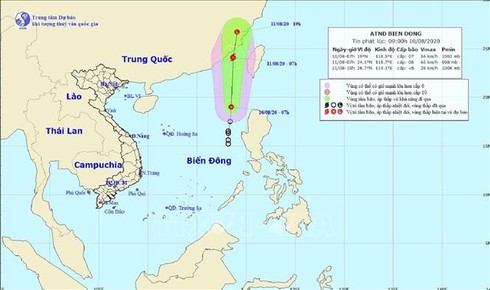
Forecasters stated that at 7am on August 10, the tropical low pressure was situated approximately 230km northwest of Luzon island of the Philippines, with winds between 40km and 60km per hour close to its centre.
Over the course of the next 24 hours, the weather pattern is forecast to move north-northeast at speeds of between 20km and 25km per hour before likely strengthening into a storm with strongest winds close to its centre reaching between 60km and 75km per hour.
All fishing vessels operating in dangerous areas have therefore been advised to stay updated on the development of the storm whilst seeking safe shelters due to possible risks of strong winds and whirlwinds.
Over the next 48 hours, the storm is expected to track north at speeds of 20km per hour before finally making landfall in Fujian of China where it will weaken into a low-pressure zone.
As a result of the impact of the tropical depression and the southwest monsoon, the East Sea will be hit by strong winds and rough seas, while heavy rain is expected to lash northern mountainous provinces, leading to the possible risk of severe flooding, landslides, and flashfloods in localities such as Ha Giang, Tuyen Quang, Yen Bai, and Lai Chau.
Moreover, a heat wave in northern provinces and the northern delta is forecast to last until August 12, with the weather pattern continuing in the central region until August 13. VOV

Vietnam to experience 5-6 storms this year
Vietnam would face 5-6 tropical storms from now until the year-end, according to Director of the National Centre for Hydro-Meteorological Forecasting Mai Van Khiem.

Strong storms forecasted to hit Vietnam this year
Vietnam would face up to 13 storms this year, including several major ones, said an official from the Ministry of Natural Resources and Environment.