 |
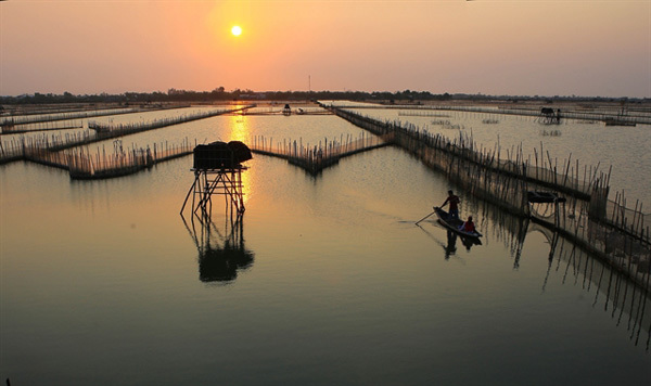
| Dam Chuon Lagoon, a community-based ecotourism site and part of the Tam Giang – Cau Hai wetland nature reserve, which was established by the Ministry of Natural Resources and the Thua Thien-Hue People's Committee in early June. VNA/VNS Photo Ho Cau |
“Ecotourism and geotourism have common features, which are community involvement, awareness of protecting the environment, geological heritage, preserving indigenous culture, and bringing economic benefits to the local communities,” says Project Head, Dr Vu Quang Lan, from the Northern Federation of Geological Maps.
“Therefore, Thua Thien-Hue Province should build plans to develop eco-tourism combined with geological tourism to thoroughly promote the Tam Giang – Bach Ma area in particular, and of the province in general.”
The Research on Geological Heritages as a Scientific Basis for the Establishment of a Global Geopark in Tam Giang – Bach Ma Area study, carried out between 2018 and 2020, identifies and classifies 115 geological heritage sites. These include five international-level, 41 national-level, and 69 local-level heritage sites.
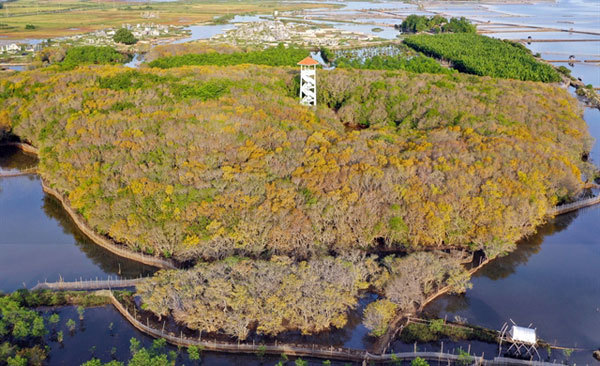 |
| UNIQUE LANDSCAPE: The specialists who reviewed Tam Giang–Bach Ma area's long history of geological development and its complex geological structure noted that the way the geography of the area has formed is relatively unique and distinctive compared to other coastal areas in Vietnam. VNA/VNS Photo Ho Cau |
Dr Lan believes one way to develop ecotourism and geotourism together in Thua Thien-Hue is to further develop ecotourism in Bach Ma National Park. This would include enabling tourists to learn more about the regional ecosystem, photograph the flora and fauna, and indulge in a touch of bird watching.
This could also include tours that incorporate learning about the geological development of Bach Ma Mountain, including the formation and development of the levelled surface on the top of the mountain; the regionally renowned landscapes, like Do Quyen Waterfall and Ngu Ho (five lakes); or the more than 400-million-year-old slate at the top of Do Quyen Waterfall.
Tam Giang – Cau Hai lagoon has also been suggested as a future sight for the development of geotourism. It has been suggested that tours are designed in which tourists can learn more about the mangrove forests and lagoon ecosystem, watch the sunrise and/or sunset over the lagoon, and also develop an understanding of the development of the lagoon.
This would include the way the Thuan An, Tu Hien and Hoa Duan estuaries have changed. This could also incorporate discussion around the architecture of the My Khanh ancient tower that belongs to the Champa culture.
Simultaneously, Thua Thien-Hue could also develop ecotourism in rural areas by offering field trips to the craft villages and farms. This could be combined with studying the formation of the Thua Thien-Hue plain and the relationship between geological and cultural heritages in the lands of the ancient capital.
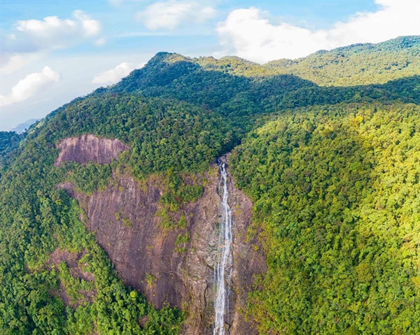 |
| INSPIRING: Located in Bach Ma National Park, Do Quyen Waterfall is seen as a natural masterpiece. Photo hoileonui.com |
The study recommends establishing a Tam Giang – Bach Ma national geopark with a focus on becoming an international geopark in the future. This is expected to become the foundation of local tourism, socio-economic development, and long-term conservation of natural heritage values, biodiversity, and culture for future generations in the region.
Prof Tran Van Tri, from the General Department of Geology, says the results of the project will form a foundation for state management agencies to protect important heritage sites and promptly prevent human activities from damaging them.
“These results will assist relevant organisations in Thua Thien-Hue, and neighbouring provinces, to conduct strategic planning for socio-economic development, particularly in the fields of tourism services, geological tourism, ecotourism, and community-based tourism.
“Local museums and related agencies of Thua Thien-Hue and neighbouring provinces will be encouraged to improve their understanding of geological heritage, participate in heritage research, conservation, management and exploitation,” he adds.
The professor also says that the results of the research conducted on the geological heritage of the Tam Giang – Bach Ma area will help to raise local people’s awareness, thereby making a positive and practical contribution to the conservation of heritage in general.
The specialists, that reviewed the area's long history of geological development and its complex geological structure, noted that the way the geography of the area has formed is relatively unique and distinctive compared to other coastal areas in Vietnam.
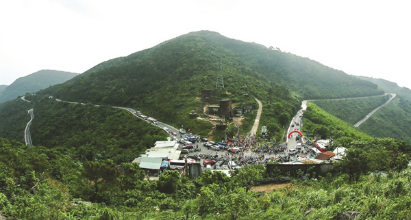 |
| ROAD TRIP: An aerial view of the Hai Van Pass, which was named among the 10 most beautiful drives in the world by US magazine Travel+Leisure in April. VNA/VNS Photo Tran Le Lam |
Tam Giang – Bach Ma also has incredible biodiversity. With a broad range of different species and ecosystems, such as tropical evergreen forests, lagoons, sand dunes, and intertidal and coastal wetland ecosystems.
The area, however, is not only geographically important, but also has a long history of cultural significance.
Tam Giang – Bach Ma, for example, has seven world heritage listings recognised by UNESCO. These include the complex of Hue Monuments, the woodblocks of the Nguyen dynasty, and the royal court music of Hue.
The study also notes that provincial cultural heritage should not only gather the characteristics and quintessence of the national culture but also showcase the original features and culture of the region.
The study highlights a potential ecotourism route that would bring together geological tourism sites throughout the province and connect the Lang Co – Hai Van – Son Cha Island.
Participants would enjoy the scenery of Lang Co Beach, Lap An Lagoon, and particularly, Hai Van Pass which has been named among the 10 most beautiful drives in the world by US magazine Travel+Leisure.
These tours would enable tourists to learn about the history of Hai Van Gate which has been dubbed “the most marvellous wonder” and to snorkel the coral reefs surrounding Son Cha Island. They would learn about the history of the formation and development of Lap An Lagoon and the massive sand dyke beside it.
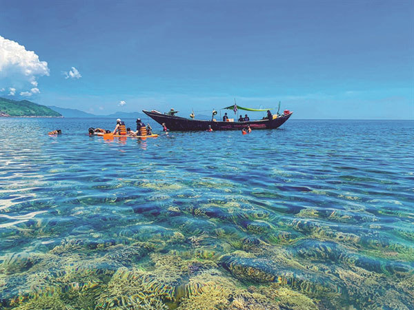 |
| MAKING A SPLASH: Tourists dive to contemplate the coral reefs surrounding Son Cha Island, located around one kilometre from the Hai Van Pass. Photo daosoncha Facebook |
Aside from identifying areas for tourism development, the project has also helped shed light on the history of coastal delta development in the central province over the past 10,000 years. In particular, sea level changes and the size of an ancient bay that developed between 10,000 and 4,000 years ago in Hue Delta that was gradually filled with materials brought by the river from then to the present day.
Vietnamese geoscientists are currently defining a set of geo-heritage values as well as identifying a national network of geoparks to conserve and promote local heritage that can be used for sustainable economic and social development.
The Tam Giang – Bach Ma area covers a total area of about 1,600 square kilometres, including Hue City, Phu Vang District, Quang Dien District and parts of Phu Loc, Huong Thuy, Nam Dong, Phong Dien districts, and Huong Tra Town.
Located within this area is the ancient royal capital of Hue which was recognised by UNESCO as a World Heritage Site on the 11th of December 1993.
The city, is abundant with unique landscapes and buildings like the Huong (Perfume) River, Ngu Mountain or Thien Mu Pagoda. As a result, it has become the inspiration for numerous poems and artworks.
Source: Vietnam News
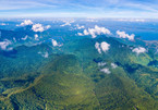
Spectacular views of Bach Ma National Park
Bach Ma National Park in Thua Thien Hue has proved a popular destination among visitors due to its spectacularly stunning views and natural landscapes that can be enjoyed from the peak of Bach Ma mountain.

Hai Van Pass, the best coast road in central Vietnam
Hai Van Pass is approximately 20km long and 500m above sea level.