Subsidence occurs both because of human activity (groundwater extraction, mining, drilling/fracking for oil and natural gas, and urban development) and because of natural causes (drought, tectonic forces, groundwater movement, natural compaction of soils).
Excessive exploitation of groundwater, construction projects, and urban development are the culprits of subsidence in Ho Chi Minh City today.
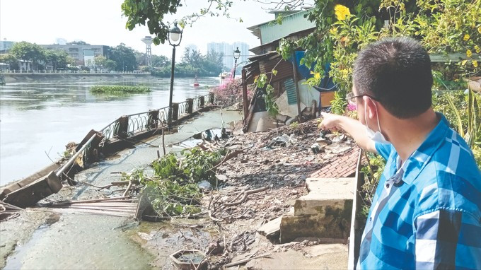
A serious landslide area at the Thanh Da canal embankment in HCMC’s Binh Thanh District shows that the embankment collapsed, and trees and many people's houses were pulled down, leaning completely towards the river. Some households have been relocated to a safe place while the remaining families are living in anxiety because continued land subsidence could occur at any time.
Previously, in June 2023, an embankment in this area collapsed and subsided, causing damage to people. The report of the People's Committee of Ward 25, Binh Thanh District shows that subsidence is about 220m long, and 2.5m wide; worse, some locations have subsided up to 1m. The preliminary cause is that the foundations of some houses are hollow because sand and construction materials are drained into the river through underground drainage when the tide recedes, causing the top of the embankment to subside.
Meanwhile, in alleys 67 and 89, Nguyen Huu Canh Street (Ward 22, Binh Thanh District, Ho Chi Minh City), many foundations of buildings get cracking with a length of about 10-20cm. According to resident Nguyen Thi Ly in alley No. 67 on Nguyen Huu Canh Street, the subsidence has been going on for about 4-5 years now. Every year the foundations of many houses crack more and more, so local inhabitants are very worried.
Foundation subsidence is also occurring because weak ground cannot support the weight of structures of a number of school buildings, and apartment buildings in An Khanh ward in Thu Duc City and many other areas in Ho Chi Minh City.
Deputy Director Truong Trung Kien of the Department of Planning and Investment of Ho Chi Minh City said that studies over the past 5 years have shown that in the past time, the city has subsided up to 81cm in some places, and the lowest place is 1.99cm. The subsidence is about 23.27cm on average. In addition to groundwater extraction and weak ground, subsidence of a sudden increase in rainfall and river water levels rising higher than normal.
Studies carried out by the Japan International Cooperation Agency (JICA) in 2005, 2014, and 2017 show that localities with significant levels of subsidence are Districts 7, 8, 12, Go Vap, Tan Binh, Binh Thanh, Phu Nhuan, Binh Tan and Thu Duc City. Particularly in District 12 and Tan Binh District, the highest level of ground subsidence was recorded.
Districts with many commercial buildings have a higher subsidence rate, about 7-8cm yearly. Subsidence monitoring using InSAR analysis by the research team of Ho Chi Minh City University of Technology also shows that land subsidence in Ho Chi Minh City in the period 2006-2020 is more severe than that in inner-city districts and districts 12, Go Vap, Tan Binh, Binh Thanh, Phu Nhuan, and Binh Tan.
Many people said that subsidence not only causes damage to people but also greatly affects the city's underground space planning.
Recently, at the supervision session of the National Assembly Delegation, the Ho Chi Minh City People's Council and the municipal People's Committee on the implementation of legal regulations in urban planning and rural planning in Ho Chi Minh City in the period from 2010 to the end of 2023, deputy Truong Trong Nghia raised the question of whether the recently approved planning task addresses the city's subsidence, waste treatment and flood prevention issues because these directly affect city dwellers' lives and the city's sustainable development. Not only that, this is also one of the issues in underground space planning for the city.
According to Deputy Truong Trong Nghia, the growing number of real estate projects, accompanied by subsidence, is making the problem of flood protection difficult. To solve this problem, delegate Truong Trong Nghia proposed that the city needs to establish detailed planning. When adjusting the general urban planning project, the city must determine which areas can be allowed to build high-rise buildings and which areas cannot be developed for real estate projects.
To minimize subsidence in Ho Chi Minh City, scientists believe that the city needs to synchronously deploy many solutions. Specifically, the first thing is to reduce the density of high-rise building construction in areas with weak soil, along with preventative measures to limit groundwater extraction in subsidence-prone areas.
According to JICA experts, land subsidence in Ho Chi Minh City is a serious problem and many solutions need to be considered. These solutions need to be implemented over a long period of time and require technology transfer. One of the top plans to limit land subsidence in Ho Chi Minh City is to control excessive groundwater exploitation.
Deputy Director Nguyen Thi Thanh My of the Ho Chi Minh City Department of Natural Resources and Environment: Fill in damaged wells without exploitation licenses.
By 2025, the city will reduce groundwater exploitation to 100,000 cubic meters a day and move toward ending groundwater exploitation; At the same time, the city will also fill in damaged wells and wells without exploitation licenses.
To achieve the set goals, the Department of Natural Resources and Environment will continue to coordinate with administrations in districts and relevant units to promote propaganda and dissemination of legal documents on water resources to metropolitan inhabitants as well as advise people to use the city's water supply while increasing information of the harmful effects of using groundwater.
SGGP