Despite slowing significantly and dissipating before making landfall, heavy rainfall persists across provinces from Ha Tinh to Quang Ngai.
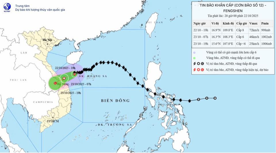
According to the National Center for Hydro-Meteorological Forecasting, as of 7 p.m. on October 22, the storm's center was located off the coast between southern Quang Tri and Quang Ngai, about 170 km east-northeast of Da Nang. Maximum wind speeds near the center reached level 8 (62–74 km/h), with gusts at level 10. The storm is moving westward at about 10 km/h.
Meteorologists report that Fengshen is weakening swiftly under the influence of a cold air mass. This interaction has disrupted the storm's cloud structure, dissipated its energy, and obscured its center.
Although rainfall levels are showing a slight decrease compared to earlier forecasts, the threat of heavy downpours remains due to a combination of cold air, easterly wind disturbances, and the complex topography of the Truong Son mountain range.
In the next 12 hours, the storm is expected to shift west-southwest at about 10 km/h and further weaken into a tropical depression.
By 7 a.m. on October 23, the depression will likely be located near the coastal area from Da Nang to Quang Ngai, with wind levels at 6 and gusts up to level 9.
Another 12 hours later, it will continue westward at 15 km/h, weakening into a low-pressure system over southern Laos.
Due to the combined effects of the storm’s circulation and intensifying cold air, strong winds are expected tonight and overnight in coastal areas from Quang Tri to Da Nang, reaching level 5-6, with gusts up to level 8.
From the night of October 22 through October 24, heavy rain and thunderstorms are forecast across Ha Tinh to Quang Ngai, with general rainfall ranging from 100-200 mm. In some areas, it could exceed 300 mm.
Specifically, from southern Quang Tri to Da Nang, rainfall could reach 200-400 mm, with some places recording over 700 mm. The most intense rainfall is expected between the night of October 22 and the end of October 23.
There is a high risk of localized heavy downpours exceeding 150 mm within three hours in coastal communes and wards from southern Quang Tri to Da Nang.
Heavy rains over central Vietnam may continue through the end of October 2025.
There is a heightened risk of flash floods and landslides in mountainous areas and flooding in low-lying and urban regions.
Local authorities are advised to manage hydropower and irrigation reservoirs safely before, during, and after the storm.
Emergency response plans should be ready for potential river flooding from southern Quang Tri to Da Nang, where water levels may reach alert level 2 or 3, with some areas exceeding level 3.
The forecast for flood-related natural disaster risk is currently at level 2–3.
People should remain alert for thunderstorms, tornadoes, and strong wind gusts within the storm’s influence zone, both before and during landfall.
Marine conditions
In the western part of the northern East Sea, including the Hoang Sa archipelago, winds are expected to reach levels 6–7. Near the storm’s center, winds may reach level 8, with gusts at level 10. Waves will rise between 3–5 meters, creating very rough seas.
From Quang Tri to Quang Ngai, including Con Co, Cu Lao Cham, and Ly Son islands, wind speeds will range from level 6–7, with gusts at level 9 and waves reaching 3–5 meters.
Coastal areas from southern Quang Tri to Da Nang may experience storm surge heights of 0.4 to 0.8 meters.
Bao Anh