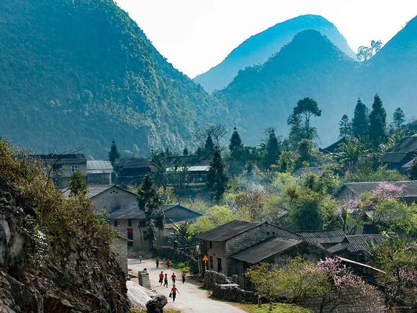
Ha Giang is located in the northernmost part of the country and has no advantage in terms of land or soil, due to its steep and arid mountainous terrain; low mountainous areas often have landslides, ethnic people make up the majority of the population... However, Ha Giang has unique characteristics in landscape, culture, people and architecture, so this rocky plateau has long been famous as a land rich in tourism potential.
The province's road system is quite complete. Currently, 100% of its communes have roads to the commune center, and most villages have inter-village concrete roads. National Highway No. 2 is a vital route running from the Thanh Thuy Border Gate Economic Zone to Hanoi with a length of over 340 km. In addition to the above route, other domestic roads connect Ha Giang with the provinces of the key economic region in the North.
In recent years, Ha Giang has been making efforts to implement Decision No. 147/QD - TTg dated January 22, 2020 of the Prime Minister on approving the strategy on Vietnam tourism development until 2030; Resolution No. 11-NQ/TU dated August 2, 2021 of the Ha Giang Provincial Party Executive Committee on tourism development in Ha Giang province for the period 2021 – 2025. On February 16, 2022, Ha Giang province issued Plan No. 43/KH-UBND on developing tourism products for the period 2022 - 2025, with a vision to 2030.
The goal of this plan is to build a system of unique, professional tourism products with Ha Giang's own brand to stimulate demand and attract investment in its tourism products as well as its tourism infrastructure, promoting the market for middle and high-end tourists, to turn Ha Giang into a locality with many tourism products of highly competitive advantages compared to other mountainous provinces in the country.
The province also aims to recognize 30 tourist destinations by 2025, to welcome about 3 million visitors, earning a total tourism revenue of 7,800 billion VND, making up 10.34% of the province's GRDP.
Another goal is that by 2030, the UNESCO Global Geopark Dong Van Karst Plateau will be recognized as a national tourist area, welcoming over 5 million visitors, with a total tourism revenue of 20,600 billion VND, contributing 14.34% of the province's GRDP.
To soon achieve the above goals, Ha Giang has formed three tourism spaces. The first is low hill and mountain tourism space. This is a mountainous and valley area along the Lo River - the driving economic region of Ha Giang, including the districts of Bac Quang, Quang Binh, Bac Me, Vi Xuyen and Ha Giang city. This area consists of the following tourist sites: Trong Con revolutionary relic site, Cang Bac Me, Sung Khanh pagoda, Binh Lam pagoda, Nam Dau pagoda, Quan Am pagoda, Mau temple....
This is also home to the historical spiritual tourism product named "Visiting the Vi Xuyen border front," with the relic sites of Vi Xuyen martyr’s cemetery, 468 incense tower, Bat cave. This region is also famous for orange and apple growing farms, community-based cultural tourism villages of the Tay and Dao ethnic groups. Ha Giang city is known as the gateway connecting the tourist route between Yunnan province (China) and Vietnam via the Thanh Thuy international border gate.
This region also has eco-tourism and resort zones such as Thanh Ha hot spring resort and Thach Lam Vien eco-tourism area. There are also festivals in this region, namely the fire dancing festival of the Pa Then people, Long Tong festival of the Pa Then people. Toc Tay, Ban Vuong of the Dao people....
The northern rocky mountainous tourism region includes the districts of Meo Vac, Dong Van, Yen Minh, Quan Ba, with average altitude from 1,000m to 1,600m and many limestone mountain areas with steep slopes, located close to the northern tropic. This region is characterized by a temperate sub-region, suitable for growing fruit trees such as plums, peaches, pears, persimmons, apples as well as precious medicinal plants like cardamom, eucommia, yucca, and corn, vegetables, legumes. The main livestock are cows, horses, goats, poultry and honey bees. The entire region has been recognized by UNESCO as a global geopark, with a total area of up to 2,368.6km2.
The tourist space in the western mountainous region, in the mountain range upstream of Chay River, includes Xin Man and Hoang Su Phi districts and some communes of Bac Quang, Quang Binh and Vi Xuyen districts on the Tay Con Linh range.
This space is associated with Hoang Su Phi terraced field national monument, which is known as one of the most unique and magnificent types of human farming that impacts the natural world through diligent hands and land reclamation techniques accumulated over thousands of years in the harsh living environment of high mountains.
After completing the procedures and documents submitted to the Ministry of Culture, Sports and Tourism to request recognition as a heritage, on November 1, 2011, Hoang Su Phi district's terraced fields were ranked as a National Monument by the Ministry of Culture, Sports and Tourism, with six communes located in the protected area and zoning map (Ban Luoc, San Sa Ho, Ban Phung, Ho Thau, Nam Ty, Thong Nguyen). The total area zoned to protect the terraced rice heritage is 764.8 hectares with 251.15 hectares of terraced fields. This will be a very attractive destination for investors in the coming years.
According to statistics, Ha Giang currently has 12 tourist destinations recognized by the Provincial People's Committee, and 16 typical community tourism cultural villages. Many tourist areas and tourist attractions have been and are being built on a large scale.
Hopefully, based on the local potential and strengths, with appropriate decisions and steps, Ha Giang will soon become an attractive tourist destination.