 |
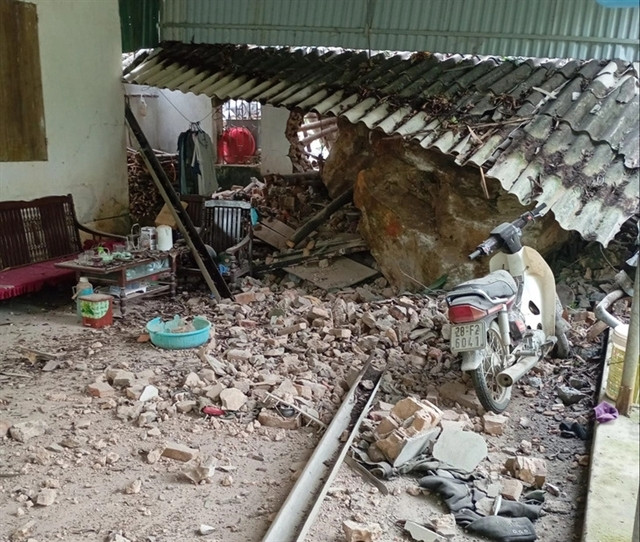
| Rocks from the mountain rolled down onto a house in Cao Dương Commune, Lương Sơn District in Hòa Bình Province following an earthquake on March 25 in Mỹ Đức District. Photo tuoitre.vn |
In recent years, earthquakes have occurred more frequently in Việt Nam and appear to be on the rise. Therefore, communities in high-risk earthquake areas need to understand this type of natural disaster and develop proactive response plans, an expert has said.
Since the beginning of 2024, Việt Nam has experienced 135 earthquakes in many localities. All were minor earthquakes with magnitudes ranging from 2.5 to 4.1.
Notably, in Kon Plong District in the Central Highlands province of Kon Tum, earthquakes occur almost daily, with sometimes seven or eight tremors happening in a single day.
Earthquakes have also been recorded in other areas across the country, including regions where they were previously rare, such as Mỹ Đức District in Hà Nội, and Ninh Bình and Yên Bái provinces.
Nguyễn Xuân Anh, Director of the Institute of Geophysics at the Việt Nam Academy of Science and Technology, stated that most of the earthquakes in 2024 have been induced by human activities, particularly hydro-electric power operations.
A small number of earthquakes were tectonic, occurring along natural fault zones.
Data from the Institute of Geophysics showed a significant increase in earthquake occurrences over the past five years. Specifically, there were 52 earthquakes in 2019, 98 in 2020, 183 in 2021, 293 in 2022, and 353 in 2023.
Particularly, from 2021 to 2023, the number of earthquakes increased three to six or seven times compared to 2019. This rise is mainly due to the increased number of induced earthquakes caused by hydro-electric reservoir operations.
Recent data also showed that the northwest region experiences the strongest earthquakes in the country due to several natural fault zones.
According to the earthquake hazard zoning map from the Institute of Geophysics, Việt Nam is not near these boundaries but is located on the Eurasian Plate, making its geology more stable. Earthquakes in Việt Nam are typically of moderate magnitude and less destructive compared to those near plate boundaries.
The strongest possible earthquakes in Việt Nam could reach a magnitude of 7.5, with a historical record of a 6.8 magnitude earthquake. These primarily occur in the northwest region and Nghệ An Province.
In other areas such as Kon Tum and major cities like Hà Nội, Đà Nẵng, and HCM City, potential earthquakes would likely range from 5.0 to 5.9. Elsewhere in the country, earthquakes are generally mild, below 5.0 in magnitude.
Most earthquakes in Việt Nam range from 5.0 to 5.9 in magnitude, causing minor structural damage like shaking houses and slight cracks in walls.
Recently, some earthquakes have occurred in areas with traditionally low seismic activity. For example, a 4.0 magnitude earthquake on 25 March in Mỹ Đức District caused tremors in nearby areas including Ứng Hòa and Chương Mỹ in Hà Nội, Kim Bôi, Lương Sơn, and Lạc Thủy in Hòa Bình Province, and Kim Bảng in Hà Nam Province.
This rare event occurred in the Red River - Lô River - Chảy River fault zone. When these faults accumulate enough energy, they generate earthquakes.
On 27 May, a 3.4 magnitude earthquake in Nho Quan District in Ninh Bình Province caused tremors in Thạch Thành District in Thanh Hóa Province. This earthquake was due to the area being in the Đà River fault zone.
 |
| An officer of Măng Cành Commune, Kon Plông District in Kon Tum Province delivers a leaflet about earthquakes for local residents. VNA/VNS Photo Dư Toán |
Regarding earthquake reporting and forecasting, Director of the Institute of Geophysics Xuân Anh stated that in the first half of 2024, most earthquakes across the country had magnitudes between 2.5 and 4.1, posing little natural disaster risk.
However, he said, earthquakes are notoriously difficult to predict, especially the precise timing of their occurrence. Therefore, understanding earthquakes and how to prepare for them is crucial, particularly in high-risk areas.
Xuân Anh said the Institute maintains a national earthquake monitoring system with nearly 40 stations nationwide. In addition, local stations monitor induced seismic activity from hydro-electric reservoirs in the northwest and Quảng Nam Province.
Recently, the institute established eight local monitoring stations in Kon Tum Province. These stations provide rapid, accurate earthquake data, essential for assessing seismic activity, dam safety and reservoir operations.
He said local authorities should develop annual earthquake response plans based on such activity and in at risk areas, it is important to increase public awareness and earthquake preparedness training.
Basic knowledge about earthquakes and how to respond is essential, he said.
During an earthquake, residents indoors should take cover under a table to protect themselves from falling objects and wait until the shaking stops, avoid using elevators due to potential power outages and turn off circuit breakers before evacuating to prevent fires from forgotten electrical appliances. — VNS