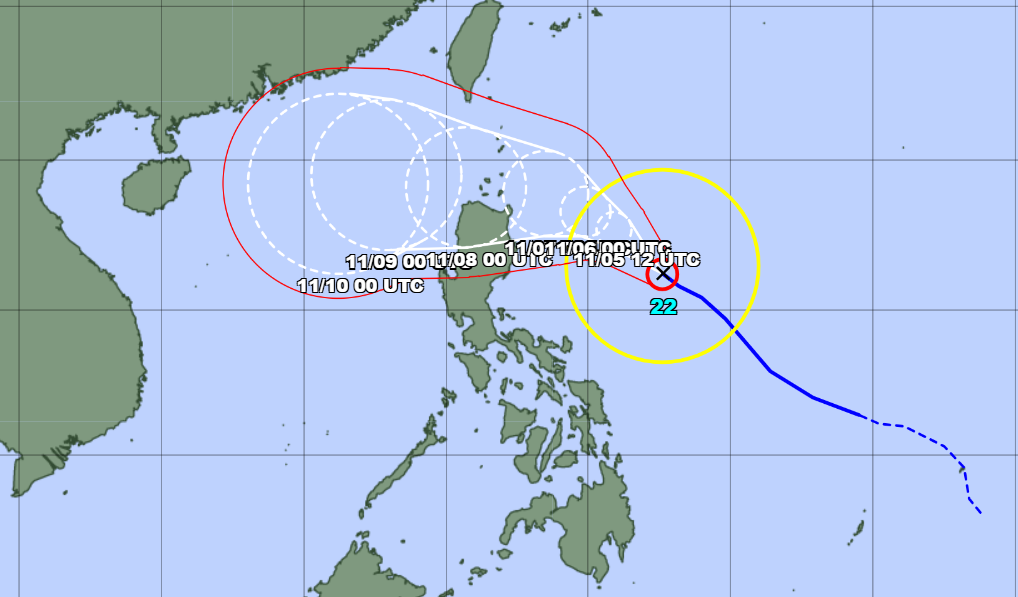
As of 6 a.m. on November 5, JMA reported that the eye of Typhoon Yinxing was located off the eastern coast of the Philippines. The storm’s maximum sustained winds were measured at level 11 (30 m/s) near the center, with gusts reaching level 14 (45 m/s).
The storm is predicted to move quickly northwestward, toward the northeastern coast of Luzon Island in the Philippines. Yinxing is likely to enter the East Sea around November 8 after skirting the northern coast of Luzon.
If the storm enters the East Sea as forecasted, it will become the seventh named storm of the year in the region.
JMA also predicts that Typhoon Yinxing will continue to strengthen over the coming days, with maximum sustained winds potentially reaching level 13 (40 m/s) and gusts up to level 16 (55 m/s).
The name "Yinxing" was proposed by China and refers to a species of tree.
East Sea weather update
According to the National Center for Hydro-Meteorological Forecasting, northeastern winds were recorded at level 6, gusting to level 7, at the Bach Long Vi station. The Gulf of Tonkin, the waters from Quang Tri to Ninh Thuan, and from Ca Mau to Kien Giang, as well as the Gulf of Thailand, have been experiencing scattered showers and thunderstorms.
Additionally, on November 5, scattered showers and thunderstorms are expected in the Gulf of Tonkin, the central and southern regions of the East Sea, and the coastal waters from Quang Tri to Ca Mau, Ca Mau to Kien Giang, and the Gulf of Thailand. Thunderstorms may bring tornadoes and gusty winds reaching level 7-8.
On November 6, northeastern winds in the Gulf of Tonkin will strengthen to level 5, occasionally reaching level 6 with gusts at level 7, creating rough seas and waves between 1.5 and 2.5 meters high.
In the northern East Sea, including the waters surrounding the Hoang Sa islands, northeastern winds are forecasted at levels 6-7, gusting to level 8-9, with rough seas and waves between 3 and 6 meters.
The coastal area from Quang Tri to Ninh Thuan is expected to experience northeastern winds at level 6, gusting to level 7-8, with rough seas and waves between 2 and 4 meters.
For the region from Binh Thuan to Ca Mau, northeastern winds are forecasted at level 5, occasionally level 6, with gusts to level 7-8, creating wave heights between 1 and 2 meters.
All vessels operating in these regions face a high risk of being impacted by tornadoes, strong winds, and large waves.
Ly Dao