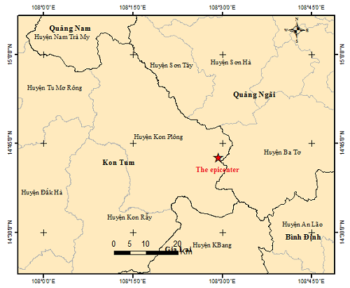
The first tremor with magnitude 3.2 was felt at 00:55 today, with a depth of 8.3 kilometers. A few minutes later, the second quake happened at 1:05 a.m. and the third was recorded at 4:12 a.m., with respective magnitudes 2.9 and 2.5.
Data from the Institute of Geophysics showed that more than 170 earthquakes have hit Kon Plong since April last year to date, which is five times higher than the figure recorded between 1903 and 2020. The quakes not only increased by frequency but they also became stronger over time.
A few days earlier, the magnitude 4.5 tremor was detected on April 18 this year, the strongest one to hit this Central Highlands district up to now.
According to Dr. Le Huy Minh from the Institute of Geophysics, these tremors could be stimulated earthquakes that usually happen when hydropower dams accumulate water and thereby put pressure on faults underneath.
Echoing this point of view, Cao Dinh Trieu, an earthquake expert, said the tremors felt in Kon Plong are probably stimulated earthquakes. The timeline that Kon Plong witnessed this string of earthquakes overlapped the timeline that the Thuong Kon Tum hydropower plant in Kon Plong was put into service on March 24 last year, Trieu said.
Especially, the earthquake-struck area is located on the Rao Quan-A Luoi fault zone, which is reportedly deemed as a strong fault zone. The zone runs from Laos, then A Luoi in Thua Thien-Hue Province to Quy Nhon City in Binh Dinh Province. Also, along this fault zone, stimulated earthquakes had been felt at the Song Tranh 2 and Dak Drinh hydropower plants in Quang Nam and Quang Ngai, respectively, when the plants were accumulating water.
Given the string of earthquakes in Kon Tum, Nguyen Xuan Anh, head of the Institute of Geophysics, suggested five urgent measures, including efforts to review and evaluate the design for anti-seismic resistance of hydropower plants and key projects in Kon Tum.
Source: Saigon Times