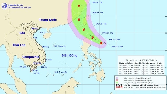
The location and projected path of Storm Danas near the East Sea. (Photo: nchmf.gov.vn)
The national weather service said that by 1 pm on July 16, the location of Storm Danas was at about 17.1 degrees north latitude and 125.5 degrees east longitude, about 330 km east of Luzon. The strongest wind near its centre was at 60-75 km/hour.
It is forecasted that in the next 24 hours, the storm will move in the west-northwest direction, at a speed of 10-15 km/hour and will become stronger. At 1 pm on July 17, its location is forecast at about 18.7 degrees north latitude and 123 degrees east longitude, on the sea north east of Luzon Island, packing wind from 60-75 km/hour.
Danas is projected to approach Taiwan (China) in the next 24 to 48 hours. For the next 48 to 72 hours, the storm would move in the north-northwest direction, at about 15 km per hour. By 1 pm on July 19, the location of the storm would be at about 23 degrees north latitude and 119 degrees east longitude, about 100 km from the coast of Fujian province (China), with winds blowing 60-90 km per hour.
In the next 72 to 96 hours, the storm will move northward at about 10-15 km per hour.
Due to the influence of the storm, heavy rains combined with strong winds and rough seas are expected for the north-eastern part of the East Sea.
In addition, due to the strong influence of the southwest monsoon, the waters from Binh Thuan to Kien Giang provinces, the Gulf of Thailand and the middle and southern part of the East Sea (including the Spratly archipelago) will suffer from showers and thunderstorms from tonight, with the possibility of tornados and strong winds.
The sea areas from Binh Thuan to Ca Mau provinces and the southern part of the East Sea (including the Spratly archipelago) have strong southwest winds and high sea levels from 2-4m.
Nhan Dan
 A reported tropical depression in the eastern part of Luzon Island (the Philippines) has strengthened into a storm and is approaching towards the waters near Vietnam’s East Sea.