According to the National Center for Hydro-Meteorological Forecasting, this morning (July 19), a low-pressure area in the eastern region of the central East Sea has intensified into a tropical depression.
At 7am, the tropical depression was centered at approximately 14.0 degrees North latitude and 118.0 degrees East longitude. The maximum wind speed near the center of the tropical depression reached level 6 (39-49 km/h), with gusts up to level 8, moving slowly northwest at a speed of 5-10 km/h.
Forecast for the tropical depression:
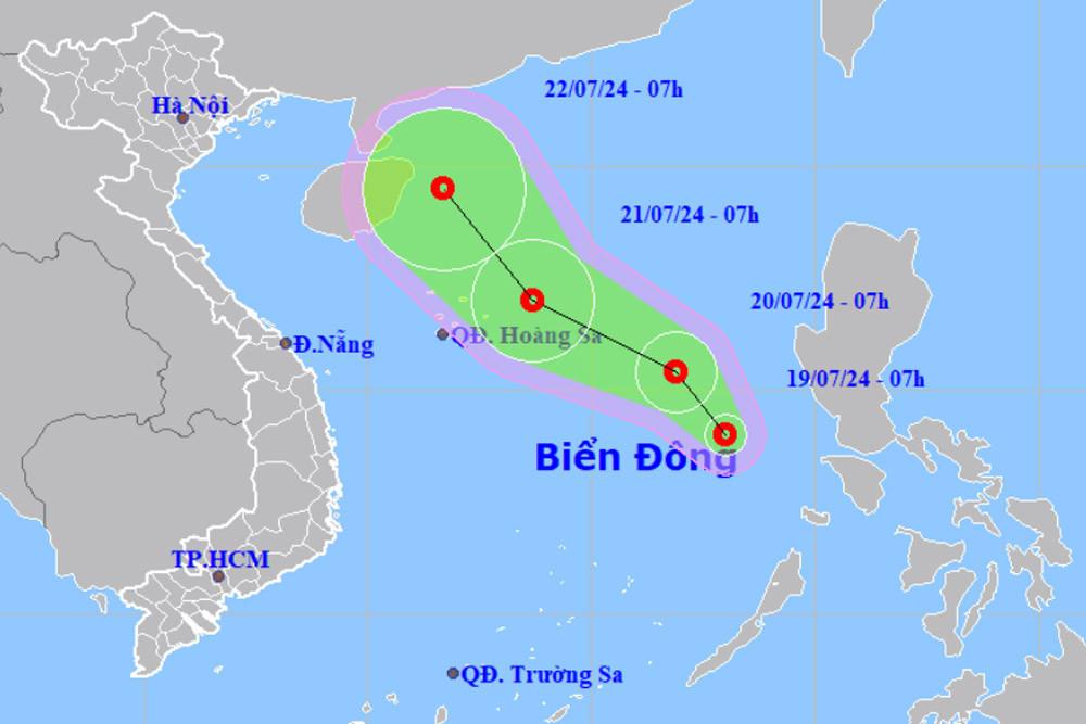
- In the next 24 hours, the tropical depression is expected to maintain its direction and increase its speed to about 10 km/h. By 7am on July 20, the center of the tropical depression is predicted to be in the eastern region of the North and central East Sea, with maximum winds reaching level 6 and gusts up to level 9.
- By 7a on July 21, the center of the tropical depression is expected to be in the northeastern waters of the Hoang Sa (Paracel) Archipelago. The maximum wind speed at this time could increase to levels 6-7, with gusts up to level 9, moving northwest at a speed of 10-15 km/h.
- From 48 to 72 hours, the tropical depression is expected to move northwest at a speed of 5-10 km/h.
The eastern waters of the North and central East Sea will experience heavy showers and thunderstorms, with strong winds reaching level 6-7, gusting up to level 9, causing rough seas with waves 2-4 meters high.
Heavy rain on land:
Last night and this morning, the Northern, North Central, and Southern regions of Vietnam experienced scattered showers and thunderstorms, with some areas receiving very heavy rain. From 7pm of July 18 to 8am of July 19, some areas recorded rainfall over 90 mm, including Cam Pha (Quang Ninh) with 123.6 mm, An Binh (Hoa Binh) with 113.0 mm, Trieu Phong (Quang Tri) with 91.4 mm, and Tieu Can (Tra Vinh) with 103.2 mm.
Forecast for today and tonight:
- The Northern and North Central regions will continue to have scattered showers and thunderstorms, with some areas experiencing heavy rain ranging from 20-40 mm, and locally up to 80 mm (rainfall concentrated in the morning and at night).
- In the afternoon and evening, the Central and South Central regions will have scattered showers and thunderstorms, with some areas experiencing heavy rain ranging from 10-30 mm, and locally up to 50 mm.
- The Central Highlands and Southern regions will have moderate to heavy rain and thunderstorms, with some areas experiencing very heavy rain ranging from 20-40 mm, and locally up to 90 mm (rainfall concentrated in the late afternoon and at night).
Thunderstorms may cause localized flooding, lightning, hail, and strong winds. Heavy rain can lead to flash floods on small rivers and streams, landslides on steep slopes, and flooding in low-lying areas. Short-term heavy rainfall may also cause urban flooding.
Weather outlook:
- From the night of July 19-20 and from July 23-27, the Northern region will have scattered showers and thunderstorms, with some areas experiencing heavy rain (rainfall concentrated in the late afternoon and at night).
- From around July 21-22, the Central region will experience localized heat. The North Central region will have scattered showers and thunderstorms, with some areas experiencing heavy rain (rainfall concentrated in the late afternoon and at night).
- The Central Highlands and Southern regions will continue to have scattered showers and thunderstorms, with some areas experiencing very heavy rain (rainfall concentrated in the late afternoon and at night) over the next week.
Bao Anh