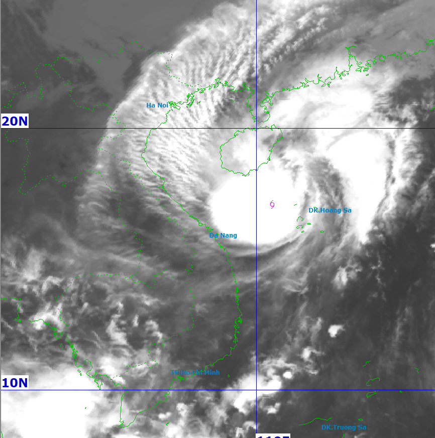
Satellite image of Storm No. 12 at 7:00 AM, October 22. Source: NCHMF
As of 7:00 AM on October 22, the National Center for Hydro-Meteorological Forecasting reported that Storm No. 12, named Fengshen, was located approximately 280 km east-northeast of Da Nang.
The storm’s maximum sustained winds near its center reached level 10 (89–102 km/h), with gusts up to level 12. It was moving west-southwest at about 10 km/h.
Due to the storm's influence, the western part of the northern East Sea, including the Hoang Sa (Paracel) archipelago, was experiencing strong winds at levels 7–8, with the area near the storm center reaching levels 9–10 and gusts up to level 12.
Waves ranged from 3 to 5 meters, reaching 5 to 7 meters near the storm center. The sea was reported as extremely rough.
From Quang Tri to Quang Ngai, including Con Co, Cu Lao Cham, and Ly Son islands, sea conditions were dangerous, with winds at levels 6–7, gusting to level 10, and waves 3–5 meters high.
Coastal areas from Quang Tri to Da Nang were warned to expect storm surge elevations from 0.4 to 0.8 meters.
All vessels operating in these hazardous zones were advised to prepare for thunderstorms, squalls, strong winds, and large waves. Low-lying coastal areas and river mouths were at risk of flooding, particularly from storm surge combined with high tides and large waves.
Landfall and inland impacts
On land, as the storm's circulation interacts with a strengthening cold front, areas from Quang Tri to Da Nang are expected to experience gradually increasing wind intensity starting this afternoon.
Wind strength in coastal regions may reach level 6, with occasional gusts at levels 7–9.
Heavy rainfall forecast from October 22 to 27
From midday October 22 through October 27, the region from Ha Tinh to Quang Ngai will experience widespread heavy rainfall, peaking from the afternoon of October 22 through October 23.
Expected total rainfall:
· Ha Tinh to northern Quang Tri and Quang Ngai: 200–400 mm, with isolated areas exceeding 500 mm.
· Southern Quang Tri to Da Nang: 500–700 mm, with some locations expected to surpass 900 mm.
Warnings have been issued for intense rainfall, potentially exceeding 200 mm within a three-hour period.
Localized rainfall predictions for Da Nang and surrounding areas
From October 22 to 27, Da Nang is forecast to experience sustained, heavy rainfall.
Expected accumulations include:
· Hai Van, Hoa Khanh, Hai Chau, Cam Le, Son Tra, Ngu Hanh Son, Hoi An, Hoa Tien, Dien Ban, Dai Loc: 500–700 mm, with localized amounts above 900 mm.
· Thang Binh, Tam Ky, Nui Thanh: 450–650 mm, potentially over 800 mm.
· Dong Giang, Tay Giang, Thanh My: 200–400 mm, with localized totals above 500 mm.
· Que Son, Tien Phuoc, Kham Duc, Tra My: 500–700 mm, possibly over 850 mm.
· Hoang Sa (Paracel Islands): 100–200 mm, with isolated areas reaching over 250 mm.
The Central Region is expected to see prolonged rainfall through the end of October 2025.
Flood, landslide, and reservoir warnings
There is a high risk of flash floods and landslides in mountainous areas and urban flooding in low-lying and coastal zones.
Authorities in affected provinces have been urged to ensure the safe operation of hydroelectric and irrigation reservoirs before, during, and after the storm.
Proactive measures are needed in response to possible flooding on rivers from Quang Tri to Quang Ngai, which may reach or exceed level 3 warning thresholds.
The national disaster risk level due to flooding and inundation has been set at Level 3.
Additionally, strong thunderstorms and squalls are expected both before and during the storm’s landfall.
Bao Anh