Although storm Kajiki (Storm No. 5) weakened into a tropical depression early on August 26, it continues to cause heavy rains across northern and north-central Vietnam, with authorities issuing high-risk warnings for flash floods and landslides in 10 provinces.
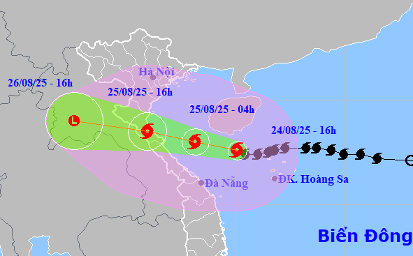
According to the National Center for Hydro-Meteorological Forecasting, at 4 a.m. on August 26, Storm No. 5 weakened into a tropical depression over central Laos. The strongest winds near the storm's center reached level 7 (50-61km/h), with gusts up to level 9.
The depression is forecast to continue moving northwest at around 20km/h today before gradually dissipating.
By 7 a.m., the storm center was located over central Laos. Over the next 12 hours, it will continue on a northwesterly path, weakening further into a low-pressure area and gradually dissipating.
Heavy rainfall continues across the northern delta and midland areas, as well as Son La, Lao Cai, Thanh Hoa, and Nghe An. Strong winds and rough seas persist in the Gulf of Tonkin.
As the weakened system moves inland, strong winds of level 6-7 (39-61km/h), gusting to level 9 (75-88km/h), are still being recorded this morning along coastal areas from Thanh Hoa to Nghe An and parts of Ninh Binh.
In the Gulf of Tonkin (including islands such as Bach Long Vi, Cat Hai, Co To, Van Don, and Hon Ngu), strong winds of level 6-7 persist, with gusts reaching level 8 and waves between 2-5 meters high. Conditions remain dangerously rough.
From early morning until the end of the day, the midlands and plains of northern Vietnam, as well as Lao Cai, Son La, and areas from Thanh Hoa to Ha Tinh, are expected to receive widespread heavy rainfall, with accumulations ranging from 50-100mm and localized amounts exceeding 200mm. Rainfall rates over 100mm within three hours are possible.
The capital, Hanoi, is also forecast to experience heavy rain and thunderstorms throughout the day. Da Nang remains dry, while Ho Chi Minh City will see showers and thunderstorms, especially in the afternoon and evening. Tornadoes and strong gusts may occur during storms.
From early August 26 to August 27, upper and central Laos will experience intense rainfall ranging from 100-250mm, with some areas of central Laos exceeding 500mm.
Devastation as Storm No. 5 hits land and weakens into a tropical depression
On the afternoon of August 25, at around 3 p.m., Storm No. 5 made landfall between Ha Tinh and Nghe An with peak gusts recorded at level 15. By 1 a.m. on August 26, as it approached the Vietnam-Laos border, the storm still maintained strong winds of level 8-9 (62-88km/h).
In Nghe An and Ha Tinh, wind speeds reached levels 8-10, with gusts as high as level 15. Diem Chau station in Nghe An recorded level 10 winds and gusts at level 12. Do Luong saw gusts up to level 15. Vinh recorded gusts at level 12, Ky Anh station (Ha Tinh) had level 8 winds with gusts at level 11, and Cam Nhuong (Ha Tinh) recorded level 10 winds with gusts at level 13.
From Thanh Hoa to Quang Tri, moderate to heavy rain was recorded, with localized rainfall exceeding 600mm.
High alert for flash floods and landslides across 10 provinces
According to the national forecasting center, from 6 a.m. on August 25 to 6 a.m. on August 26, widespread heavy rain was recorded across provinces including Son La, Lao Cai, Phu Tho, Bac Ninh, Quang Ninh, Thanh Hoa, Nghe An, Ha Tinh, and Quang Tri.
Rainfall totals included 210.2mm at Km46 (Son La), 214mm at Cao Pha3 (Lao Cai), 433.8mm at Van Mai (Phu Tho), 123.8mm at Tan Son (Bac Ninh), 298.4mm at Ky Thuong (Quang Ninh), 537.4mm at Van Xuan1 (Thanh Hoa), 484.2mm at Hua Na hydropower plant (Nghe An), 575.2mm at Ho Thuong Tuy (Ha Tinh), and 269.8mm at Hoa Son (Quang Tri).
Between 2 a.m. and 6 a.m. on August 26 alone, Lang Son province experienced moderate to heavy rain, including 102mm in Chi Lang and 87.8mm in Van Ninh. Soil moisture models indicate saturation (above 85%) or full saturation in several regions.
In the next 3-6 hours, continued rainfall is expected across these provinces. Quang Ninh, Lang Son, and Bac Ninh will see 20-50mm, with isolated totals over 80mm. Phu Tho, Son La, Lao Cai, Thanh Hoa, Nghe An, and Ha Tinh are forecast to receive 40-80mm, with localized totals exceeding 150mm. Quang Tri will see 30-50mm, with some areas exceeding 70mm.
As of 6 a.m. on August 26, the next 6 hours will be critical for monitoring flash floods in small rivers and streams, and landslides on steep slopes in many communes and wards across the 10 affected provinces.
Bao Anh