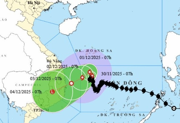
According to the National Center for Hydro-Meteorological Forecasting, as of 7 a.m. on November 30, the storm's center was located in the northwestern part of the central East Sea. The maximum sustained winds near the eye reached level 9 (75–88 km/h), with gusts up to level 11.
The storm is currently drifting north-northeast at about 3km/h.
Forecasts indicate that today the storm will continue slowly moving toward the northeast and then north. By December 2, it may shift southwest, heading toward the coastal waters off the South Central region of Vietnam while gradually weakening.
In the next 24 hours, the storm is expected to maintain a northern path at around 3km/h with minimal change in strength. By 7 a.m. on December 1, the storm's center will still be in the northwestern part of the central East Sea, roughly 320 kilometers east of the coastal provinces of Gia Lai and Dak Lak (formerly within Binh Dinh–Phu Yen). Wind speeds are forecast to remain at level 9 with gusts at level 11.
Over the following 24 hours, the storm will veer southwest at approximately 5km/h, and its intensity will gradually diminish. By 7 a.m. on December 2, it will be about 220 kilometers east of the same coastal region, with wind strength reduced to level 8 and gusts to level 10.
Within the next 24 hours, the storm will continue west-southwest at 5–7km/h and weaken further into a tropical depression. By 7 a.m. on December 3, the tropical depression will be positioned in the waters off Gia Lai to Khanh Hoa, about 100 kilometers east of the coast, with wind speeds near the center at level 6 and gusts at level 8.
From 72 to 96 hours from now, the tropical depression is expected to move west-southwest at around 10km/h, make landfall in the South Central region, and degrade into a low-pressure zone.
Due to the storm’s influence, the northwestern area of the central East Sea will experience strong winds at level 7. Areas closer to the eye of the storm will see winds at levels 8–9 with gusts up to level 11. Sea waves could reach 3–5 meters in height, and up to 5–7 meters near the center, causing extremely rough sea conditions.
Vessels operating in these hazardous waters are at risk of encountering thunderstorms, whirlwinds, strong winds, and large waves.
Bao Anh