 Vietnamnet.vn

 Podcast



Storm Narra moves slowly, expected to weaken
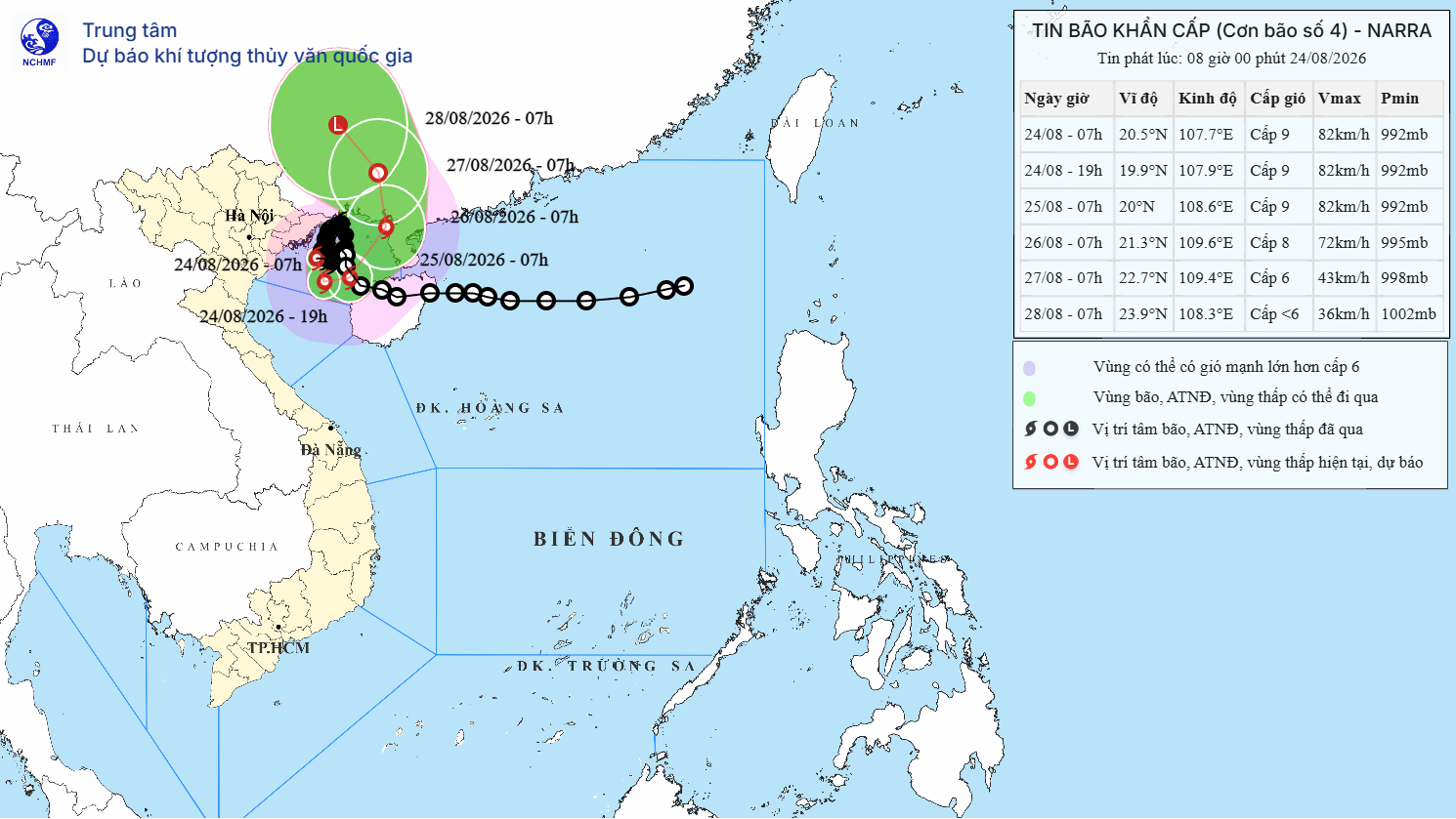
Storm Narra, the fourth storm to affect Vietnam this year, was over waters north of the Bach Long Vi special zone on the morning of August 24, about 120km east-southeast of Quang Ninh and 120km east of Hai Phong, according to the National Center for Hydro-Meteorological Forecasting.
Maximum sustained winds near the storm’s center were at level 9 on Vietnam’s wind scale, with gusts reaching level 11.
Under the storm’s impact, Bach Long Vi in Hai Phong recorded level-9 winds and level-11 gusts.
Co To in Quang Ninh recorded level-6 winds with gusts at level 9, while Mong Cai experienced level-7 winds and level-9 gusts. Winds in Uong Bi reached level 6, gusting to level 7.
At Phu Lien in Hai Phong, winds reached level 7, with gusts at level 8.
Over the next 24 hours, Narra is forecast to continue moving slowly and could turn southeast while maintaining level-9 winds and level-11 gusts. It is then expected to weaken.
Heavy rain continues, with some areas exceeding 120mm
Narra’s circulation brought moderate to heavy rain, with very heavy downpours in some locations, across northeastern Vietnam, southern Phu Tho and Thanh Hoa overnight and early on August 24.
Several locations recorded more than 100mm of rain, including Tu Minh in Hai Phong with 121.6mm, Gia Vien in Ninh Binh with 124.8mm and Tan Hoa in Hung Yen with 110.8mm.
Throughout August 24, the storm’s circulation is expected to continue bringing rain to the northeast, southern Phu Tho and the north-central region.
Hai Phong, Hung Yen, Ninh Binh and Thanh Hoa are forecast to receive 40-100mm of rain, with localized totals exceeding 200mm.
Heavy rainfall is expected to gradually ease from the night of August 24.
Several rivers exceed the highest flood warning level
Flood conditions across rivers in northeastern Vietnam remain a serious concern.
Floodwaters on the Ky Cung and Bac Giang rivers have peaked and are receding, while the Trung, Luc Nam and Thuong rivers continue to rise, all above alert level 3 - the highest level in Vietnam’s three-tier flood warning system.
The Cau River at Dap Cau, meanwhile, remained below alert level 2.
At 6am on August 24, river levels were recorded as follows:
The Trung River at Huu Lung stood at 21.23m, 2.23m above alert level 3.
The Ky Cung River at Lang Son reached 256.52m, 0.52m above alert level 3.
The Bac Giang River at Van Mich was at 190.56m, 0.56m above alert level 3.
The Luc Nam River at Luc Nam reached 7.14m, 0.84m above alert level 3.
The Thuong River at Phu Lang Thuong stood at 6.49m, 0.19m above alert level 3.
The Cau River at Dap Cau was at 5.16m, 0.14m below alert level 2.
Forecasts indicate that during August 24 and into the night, the Trung River could reach around 21.25m, approximately 2.25m above alert level 3, before beginning to recede.
Floodwaters on the Ky Cung and Bac Giang rivers are expected to continue falling.
The Luc Nam River, however, is forecast to continue rising and could reach 7.45m, about 1.15m above alert level 3.
The Thuong River could rise to 7.1m, around 0.8m above alert level 3.
At Dap Cau, the Cau River could reach 6.05m, about 0.25m below alert level 3.
Weather authorities warned that the risk of flooding in low-lying and riverside areas would remain high throughout August 24, particularly along the lower reaches of the Luc Nam, Thuong and Cau rivers.
The danger is heightened by river levels that are still rising while heavy rain continues across many areas.
Authorities and residents in flood-prone communities have been advised to closely monitor rainfall and river conditions.
As rainfall begins to ease from the night of August 24, water levels on rivers are also expected to gradually decline.
Bao Anh
.svg)
