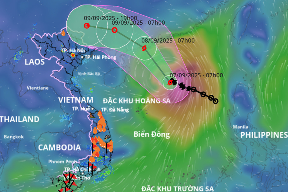
According to the National Center for Hydro-Meteorological Forecasting, Storm Tapah (Storm No. 7) has shown very little movement over the past three hours.
As of 7:00 a.m. on September 7, the storm's center was located in the northern part of the East Sea, approximately 350 km northeast of the Paracel Islands and about 450 km south of Hong Kong, China. The strongest winds near the center reached level 9 (75–88 km/h), with gusts up to level 11.
Over the next 24 hours, the storm is expected to move northwestward at 10–15 km/h and continue to strengthen. By 7:00 a.m. on September 8, the storm’s center is projected to be offshore of Guangdong Province, with wind speeds increasing to level 10 and gusts reaching level 13. The disaster risk level for the northern East Sea region has been rated level 3.
In the following 24 hours, the storm is forecast to maintain its direction and speed while gradually weakening. By 7:00 a.m. on September 9, the center of the tropical depression will be over land in Guangdong Province with wind speeds reduced to level 6 and gusts at level 8. The disaster risk level for the northwestern East Sea will remain at level 3.
In the next 12 hours, the storm is expected to shift direction slightly west-northwest at a speed of 15–20 km/h, weakening further into a low-pressure system. By 7:00 p.m., the low-pressure area will move inland over Guangxi Province, China, with wind speeds below level 6.
Due to the storm's influence, the northern East Sea will experience strong winds of level 7–8, with areas near the center reaching levels 9–10 and gusts up to level 13. Waves will rise to 3–5 meters, creating highly turbulent seas.
All vessels operating in the affected zones face risks from thunderstorms, waterspouts, strong winds, and high waves.
Bao Anh