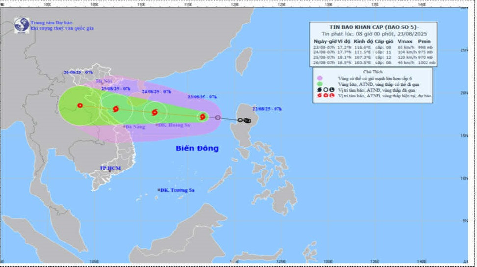
According to the National Center for Hydro-Meteorological Forecasting, on the morning of August 23, the tropical depression in the northeastern waters of the East Sea officially intensified into Storm No. 5, internationally named Kajiki.
At 7 a.m., the storm’s center was located at approximately 17.2°N latitude and 116.6°E longitude, about 480 km east-northeast of the Paracel Islands. Wind speeds near the storm’s center reached category 8 (62–74 km/h), with gusts up to category 10. Kajiki is moving west-northwest at a speed of 25 km/h.
Forecast for the next 24 to 72 hours
Due to the storm's influence, the northern part of the East Sea, including the Paracel Islands, will experience winds of category 8–9, with areas near the storm's center reaching category 10–11 and gusts up to category 14. Wave heights will range from 4.0 to 6.0 meters, and the sea will be extremely rough.
From the afternoon of August 24, coastal waters from Thanh Hoa to Hue, including Con Co and Hon Ngu islands, will see wind intensities increasing from category 6–8 to 9–10. Near the storm’s center, winds may reach category 11–12 with gusts up to category 15. Waves will rise from 4.0 to 6.0 meters, and even 6.0 to 8.0 meters in some areas. The sea is forecast to be extremely rough.
From the night of August 24, the northern Gulf of Tonkin (including Bach Long Vi Island) will experience winds of category 6–7 with gusts up to category 9. Waves will reach 2.0 to 3.0 meters, making conditions unsafe.
Coastal regions from Thanh Hoa to Quang Tri may experience storm surges of 0.5–1.0 meters. Expected water levels are 3.2–3.6 meters in Sam Son (Thanh Hoa), 3.3–3.7 meters in Hon Ngu (Nghe An), 3.1–3.4 meters in Vung Ang (Ha Tinh), and 1.7–2.0 meters in Cua Gianh (Quang Tri).
The meteorological center has issued strong warnings: Weather conditions on the sea and coastal areas during the storm will be extremely hazardous. No vessels or structures - such as tourism boats, passenger ships, transport vessels, fish farms, embankments, or coastal roads - should operate within the danger zone. There is a high risk of capsizing, structural damage, flooding, and destruction due to strong winds, high waves, and rising seawater.
On land, from the night of August 24, strong winds will affect areas from Thanh Hoa to Quang Tri, ranging from category 7–9. Areas near the storm’s center could see winds at category 10–12 with gusts up to category 14.
From the night of August 24 to the end of August 26, widespread heavy rainfall is expected across the Red River Delta, Thanh Hoa, and down to Hue. Rainfall in these areas is expected to range between 100–150mm, with some areas seeing over 250mm. Particularly from Thanh Hoa to Quang Tri, heavy to very heavy rainfall is forecast, ranging from 150–300mm, with localized areas potentially exceeding 600mm. Authorities have issued warnings for extremely intense rainfall exceeding 200mm within a 3-hour period.
From August 25 to 26, Hanoi and Da Nang are expected to experience moderate to heavy rain and thunderstorms. In Ho Chi Minh City, evening and nighttime showers and thunderstorms are likely. Dangerous weather conditions such as tornadoes and strong wind gusts may occur during these storms.
Bao Anh