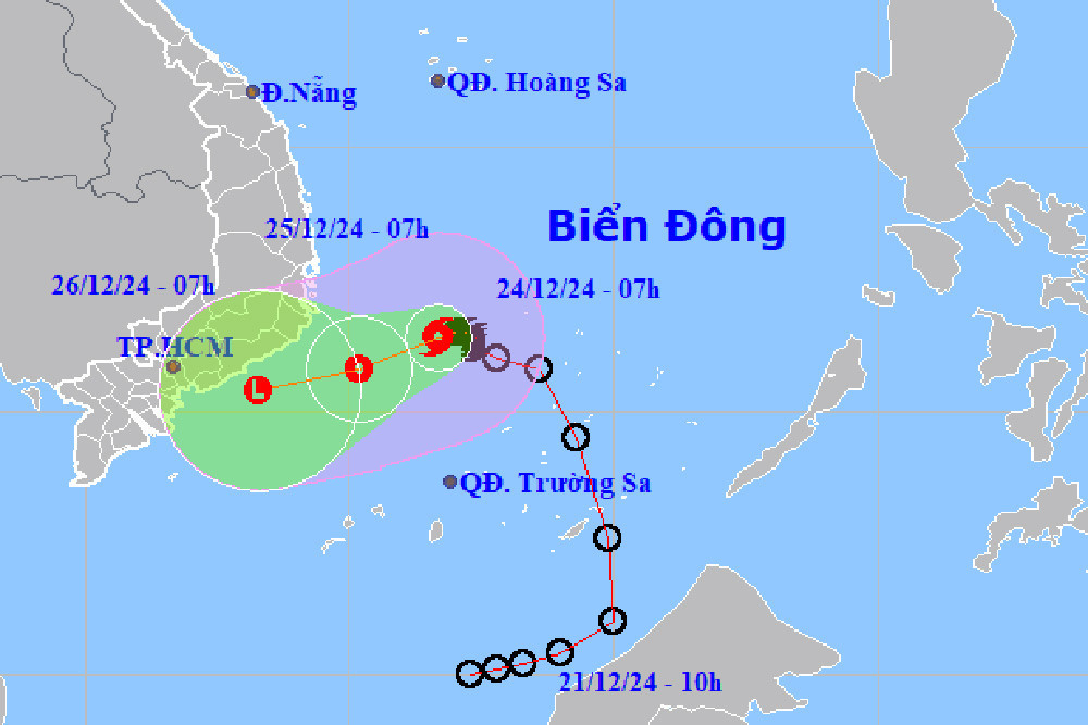
According to the National Center for Hydro-Meteorological Forecasting (NCHMF), as of 7:00 a.m. today (December 24), the storm's center was located over the southwestern part of the central East Sea. Winds near its center reached levels 8 (62-74 km/h), with gusts at level 10, moving west-southwest at 5-10 km/h.
Over the next 24 hours, the storm will maintain its trajectory and speed while gradually weakening into a tropical depression. By 7:00 a.m. tomorrow (December 25), it is predicted to be a tropical depression off the coast between Khanh Hoa and Binh Thuan provinces, with maximum sustained winds of 62-74 km/h and gusts reaching level 9.
By December 26, the tropical depression is forecast to further weaken into a low-pressure area over the seas from Ninh Thuan to Ba Ria-Vung Tau provinces, moving west-southwest at 10 km/h.
Impacts on marine and coastal areas
The storm's weakening circulation will still affect marine areas. Southwest of the central East Sea and northwest of the southern East Sea, including the northwestern waters of the Spratly Islands, are expected to experience strong winds at level 6-7, near the center at level 8, with gusts reaching level 10. Waves could rise to 4-6 meters, resulting in rough seas.
Coastal waters from Khanh Hoa to Binh Thuan, including Phu Quy Island, will see strong winds at level 6-7, with gusts at levels 8-9 and waves reaching heights of 3-6 meters.
Authorities have warned vessels operating in these areas of potential thunderstorms, strong winds, and high waves.
Rainfall forecast for central and southern regions
Mr. Hoang Phuc Lam, Deputy Director of the NCHMF, noted on the evening of December 23 that the storm would weaken over the sea, minimizing its direct impact on mainland Vietnam. However, the storm's circulation combined with a northeastern monsoon will bring significant rainfall to central and southern regions.
Rainfall has already begun in parts of the Central Central region since the night of December 23. From early today until the night of December 25, areas from Da Nang to Khanh Hoa are expected to experience moderate to heavy rains, with localized intense downpours. Rainfall amounts are forecast between 70-170 mm, with some areas exceeding 300 mm.
Ninh Thuan, Binh Thuan, and the eastern Central Highlands will see lighter rainfall, with totals ranging from 15-40 mm, but some localized areas may receive over 70 mm.
In southern Vietnam, including Ho Chi Minh City, the weather will be partly cloudy, with sunshine during the day and scattered showers in the evening. Some areas may experience moderate to heavy rains accompanied by thunderstorms.
The NCHMF has issued warnings about possible thunderstorms, lightning, and strong winds in affected areas during rains. Heavy rains could lead to localized flooding in low-lying areas, flash floods in small rivers and streams, and landslides on slopes.
Bao Anh