Typhoon Bualoi, the 10th storm to hit Vietnam in 2025, is rapidly moving toward the country and is expected to make landfall between Nghe An and Quang Tri provinces between the evening and night of September 28. The storm is forecast to pack winds equivalent to Typhoon Kajiki earlier this year, with gusts reaching level 12.

According to the National Center for Hydro-Meteorological Forecasting and the Department of Meteorology and Hydrology, Typhoon Bualoi formed over the eastern Philippines with wind speeds reaching level 12 before making landfall there on September 26.
Later that evening, the storm weakened slightly to level 11, gusting at level 13, and entered the East Sea, officially becoming Vietnam’s 10th typhoon of 2025.
Currently, Bualoi is sustaining wind speeds at level 11-12, moving west-northwest at a rapid pace of approximately 35 km/h. As of 10 a.m. on September 27, the storm was located about 370 km east-southeast of the Hoang Sa (Paracel) Islands.
Rapid intensification near the coast
Experts note that Bualoi is one of the fastest-moving typhoons on record, nearly twice as fast as average, with increasing intensity as it approaches land. Its wide radius and powerful winds are likely to trigger a combination of extreme weather events including heavy rainfall, flash floods, landslides, and coastal flooding.
Initial reports from the Philippines indicate at least four fatalities and over 433,000 people evacuated due to landslides and flooding caused by the storm.
Forecasts from Vietnam and international agencies
On the afternoon of September 25, Vietnam's meteorological agency issued the first warning about the typhoon, expecting it to enter the East Sea with level 13 intensity, gusting to level 16. The storm was projected to head toward the northern and north-central regions of Vietnam.
By the evening of September 26, authorities issued an urgent storm warning. The storm was forecast to hit central coastal waters by the morning of September 28 and make landfall from Nghe An to northern Quang Tri later that day.
Due to its broad circulation, the storm is expected to bring strong winds to coastal provinces from Thanh Hoa to Thua Thien Hue.
“This is a very strong typhoon. Wind speeds on land may match or exceed those of Typhoon Kajiki, which struck Ha Tinh earlier this year with sustained winds of level 8-10 and gusts of level 12,” a meteorologist stated.
International forecasts initially varied when the storm was still far offshore. But after entering the East Sea, most agreed it would make landfall between Nghe An and Quang Tri on the night of September 28. Some differences remain in wind intensity projections.
Japan and China’s meteorological agencies forecast the storm will hit Vietnam on September 28 with wind speeds at level 12, gusting to level 15.
Hong Kong’s forecast places the storm in the Ha Tinh–northern Quang Tri region with level 13 winds, gusting to level 16.
The U.S. Navy’s forecast predicts landfall in Quang Tri with level 13 winds (equivalent to level 12 on Vietnam’s scale), gusting to level 15.
AI-generated projections, in cooperation with Weather News and Google, anticipate landfall in Ha Tinh–northern Quang Tri with wind levels of 10–12, gusting to level 14.
Sea warnings and maritime impacts
Northern and central areas of the East Sea, including the Hoang Sa archipelago, are experiencing winds of level 8–9, increasing to level 10–13 near the storm’s eye, with gusts up to level 16. Waves may reach 6–10 meters, with extremely rough seas.
From the evening of September 27, coastal waters from Thanh Hoa to Quang Ngai - including Hon Ngu, Con Co, and Ly Son Islands - are expected to see winds intensifying to level 6–7, gusting to level 8–9, with waves of 3–5 meters.
By early September 28, wind speeds will increase further to level 8–9, peaking at level 10–13 near the storm center, with gusts up to level 16 and waves of 5–7 meters - strong enough to sink large vessels.

In the northern Gulf of Tonkin (including Bach Long Vi, Van Don, Co To, Cat Hai, and Hon Dau islands), wind is expected to increase to level 8–9 by the morning of September 28, with gusts up to level 11 and waves reaching 5 meters.
Coastal areas from Ninh Binh to Ha Tinh may experience storm surges of 1–2 meters, with Thanh Hoa and Nghe An facing the highest surge risks (1.5–2 meters). High tides and storm surges could flood dikes, coastal roads, and river mouths on the evening of September 28.
Authorities warn that the storm will make coastal and nearshore operations extremely hazardous. All vessels, aquaculture facilities, and coastal infrastructure are at high risk of damage or destruction due to strong winds, high waves, and storm surge.
Land-based impacts and heavy rainfall
From the afternoon of September 28, areas from Thanh Hoa to northern Quang Tri will begin experiencing winds of level 6–7, intensifying to level 8–9, and peaking at level 10–12 near the storm center. These winds can topple trees, power lines, and cause extensive property damage, with gusts reaching level 14. Coastal areas from Quang Ninh to Ninh Binh and southern Quang Tri to Hue will also see strong winds (level 6–7), gusting to level 8–9.
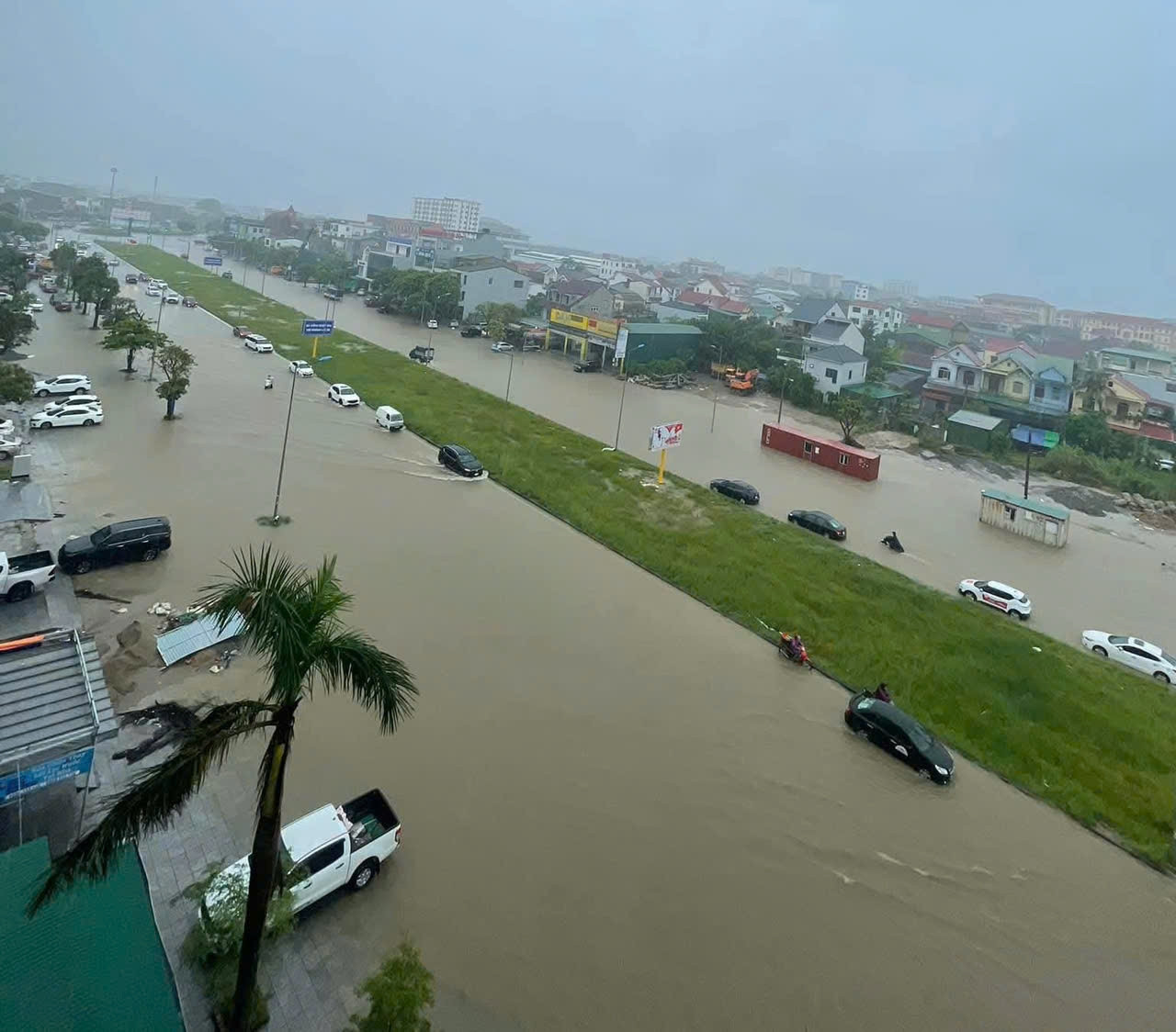
From September 27 to 30, the northern region and areas from Thanh Hoa to Hue will experience widespread rainfall, with totals ranging from 100–300mm, and some locations exceeding 400mm. In the northern delta and the Thanh Hoa–Ha Tinh region, rainfall is expected to reach 200–400mm, with isolated areas receiving over 600mm.
From September 28 to 30, moderate to major floods are expected on rivers in the north and central regions, with flood peaks reaching warning level 1–2, and in some areas, exceeding level 3.
Bao Anh