According to the National Center for Hydro-Meteorological Forecasting, after making landfall over the Luzon Peninsula in the Philippines as a super typhoon, Fung-Wong weakened slightly early this morning (November 10) and moved into the East Sea, officially becoming storm No. 14 of the year.
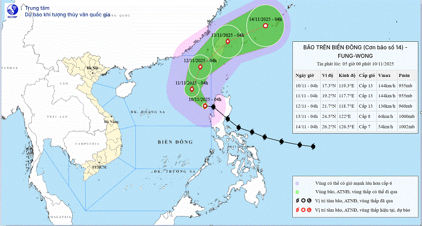
At 4 a.m., the storm’s center was located in the eastern area of the northern East Sea. The strongest winds near the center were at level 13 (134-149 km/h), with gusts reaching level 16. The storm was moving in a west-northwest direction at about 25 km/h.
According to meteorological agencies, after entering the East Sea, the subtropical high-pressure ridge to the north that typically guides storm trajectories weakened and extended further south. As a result, the storm did not follow the usual westward path but instead began shifting northward.
As the storm moved to higher latitudes, it entered a new jet stream in the upper atmosphere, likely causing it to change course toward the northeast and eventually exit the East Sea.
Specifically, within the next 24 hours, the storm is expected to shift its direction from west-northwest to northwest and slow down to a speed of 10-15 km/h. By 4 a.m. on November 11, the storm’s center is projected to remain over the eastern part of the northern East Sea, maintaining its intensity at level 13 with gusts of level 16.
Over the following 24 hours, the storm is forecast to change direction again, this time heading north-northeast at a similar speed. By 4 a.m. on November 12, its center will likely be located in the northeastern area of the northern East Sea, still maintaining level 13 intensity with level 16 gusts.
In the next 24 hours after that, the storm is expected to shift further to the northeast at a speed of 15-20 km/h. By 4 a.m. on November 13, it is predicted to approach the coastal waters northeast of Taiwan (China), weakening to level 8 with gusts of level 10.
Between 72 and 96 hours from now, the storm will continue moving east-northeast at 20-25 km/h while gradually weakening.
According to experts, storms that occur late in the typhoon season typically travel west or west-southwest and often impact Vietnam’s south-central provinces. However, Fung-Wong’s northward shift and exit from the East Sea are highly unusual.
Thus, after roaming the East Sea for around two days with level 13 intensity, typhoon No. 14 (Fung-Wong) is expected to move northward with minimal likelihood of making landfall in Vietnam.
Nevertheless, due to the storm’s influence, the eastern waters of the northern East Sea today and tonight will experience strong winds of level 8-10. Areas near the storm’s center will experience winds of level 11-13 and gusts of level 16, with sea waves reaching 5-8 meters, and up to 8-10 meters near the center. The sea will be extremely rough.
In the eastern part of the central East Sea, winds are forecast at level 6-7 with gusts at level 8-9. Seas in this region will also be rough, with waves from 6-8 meters.
Additionally, rain and thunderstorms are expected in the eastern waters of both the northern and central East Sea today and tonight. These storms may be accompanied by tornadoes and strong gusts.
A warning has been issued for continued severe weather over the eastern northern East Sea tomorrow and tomorrow night, with winds at level 8-10, gusts of level 16, and waves as high as 8-10 meters. The disaster risk level at sea is set at level 2, and specifically at level 3 for the eastern northern East Sea.
All vessels operating in these hazardous areas are at risk of encountering thunderstorms, waterspouts, strong winds, and high waves.
Bao Anh