Due to its influence, severe winds were recorded at various observation stations: Bach Long Vi (Hai Phong) experienced level 7 winds with level 9 gusts; Co To (Quang Ninh) had level 6 winds, gusting to level 9; Bai Chay (Quang Ninh) registered level 6 with gusts up to level 8; Hon Ngu (Nghe An) reported level 7 winds, gusting to level 8; Con Co Island (Quang Tri) saw level 6 winds, gusting to level 8.
As of 4 a.m. this morning, the storm’s eye was located at approximately 18.3°N latitude and 107.7°E longitude, around 220km east-southeast of Nghe An, 200km east of Ha Tinh, and 180km northeast of northern Quang Tri.
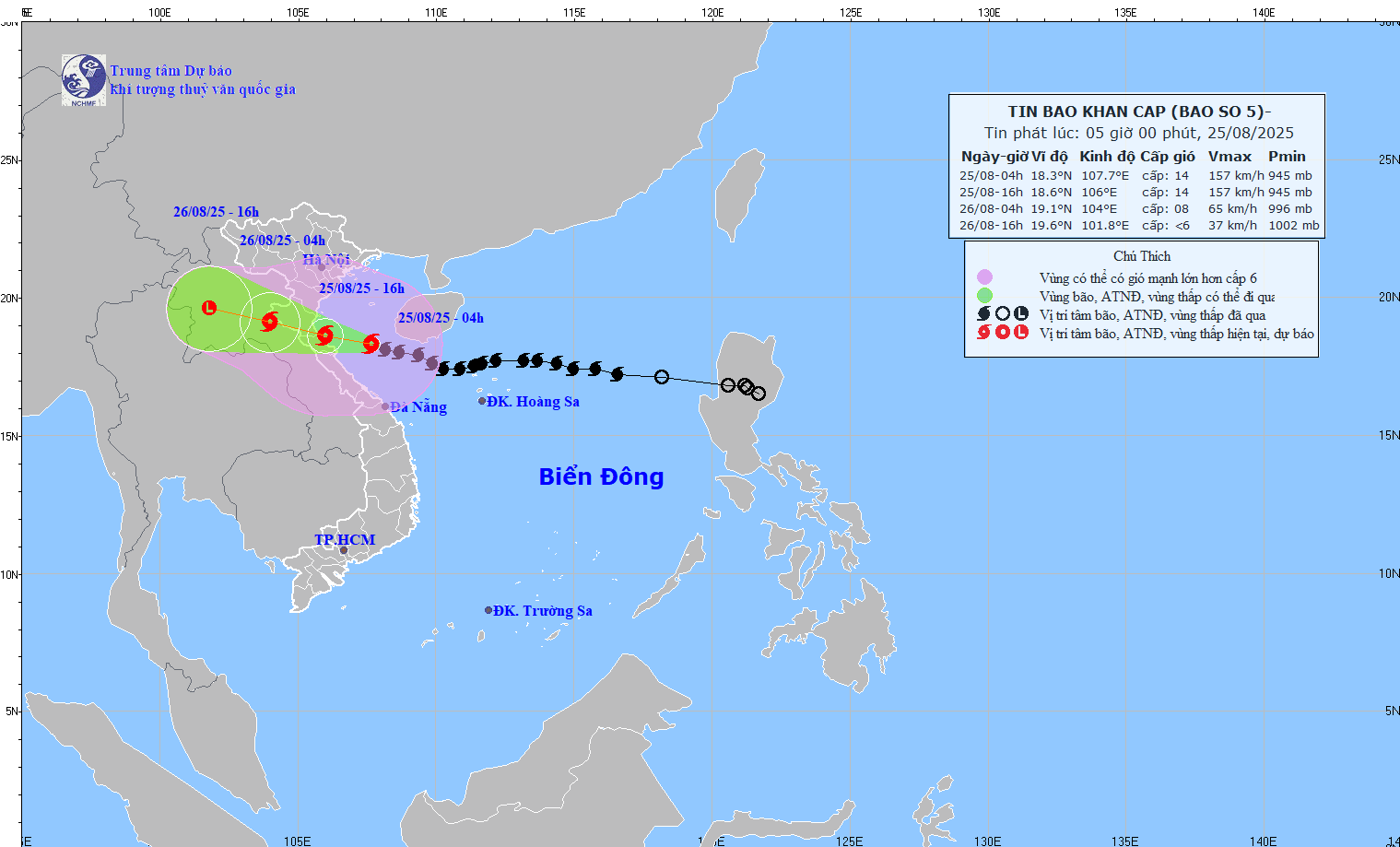
Storm intensity and forecast track: After strengthening to level 14 (150-166 km/h), with gusts reaching level 17 since 6 p.m. yesterday (August 24), Typhoon Kajiki has maintained its strength. It continues to move west-northwest at about 20 km/h.
According to Khiem, the storm is expected to continue along this path and speed for the next 12 hours. By 4 p.m. today, the storm’s center will still be offshore between Thanh Hoa and northern Quang Tri with level 14 winds and gusts up to level 17.
Forecasted wind strength on land this afternoon (as of 7 a.m., August 25):
Northern Thanh Hoa: Level 8-9 winds, gusts to level 10-11
Southern Thanh Hoa to northern Ha Tinh: Level 10-11, near the eye level 12-14, gusts 15-16
Southern Ha Tinh to Quang Tri and coastal areas from Quang Ninh to Ninh Binh: Level 6-8, gusts 9-10
After landfall, the storm will move inland over Thanh Hoa to Quang Tri, with the strongest winds affecting southern Thanh Hoa to Ha Tinh at level 12-14, gusts up to level 15-16. By 4 a.m. tomorrow, the storm’s center is expected to be over central Laos, weakened to level 8, gusting to level 11, before further degrading into a tropical depression and then a low-pressure system in the following 12 hours.
At sea: Due to the storm, the western part of the northern East Sea today will have winds at level 6-7, gusts up to level 9, waves 3-5m high, and very rough seas.
Waters from Thanh Hoa to Quang Tri (including Hon Ngu Island and Con Co Special Zone) will face winds of level 7-9, increasing to level 10-11, and up to level 12-14 near the storm’s center with gusts up to level 17. Waves may reach 5-7m, and 8-10m near the storm’s eye, causing extremely rough seas.
The northern Gulf of Tonkin (including Cat Hai, Co To, and Van Don) will see winds of level 6-7, gusting to level 9. The southern Gulf (including Bach Long Vi Special Zone) will face level 8-9 winds, gusting to level 11, and 3-5m waves, creating very dangerous sea conditions.
Storm surge: Coastal regions and islands from Hai Phong to northern Quang Tri will face storm surge heights between 0.5m and 1.8m. In Thanh Hoa and Nghe An, levels could range from 1.0m to 1.8m. Specific tide gauge readings: Hon Dau (Hai Phong) 3.5-4.0m, Ba Lat (Ninh Binh) 1.8-2.3m, Sam Son (Thanh Hoa) 3.7-4.2m, Hon Ngu (Nghe An) 3.5-4.0m, and Cua Nhuong (Ha Tinh) 2.2-2.6m.
There is a high risk of flooding in levees, coastal roads, and estuarine areas due to storm surge combined with high waves this afternoon and evening (August 25).
Severe warning for sea and coastal areas: Maritime and coastal land areas within the storm’s path are deemed extremely hazardous and unsafe for any vessels or infrastructure, including tourist boats, passenger ferries, cargo ships, fish farms, levees, and coastal roads. Vessels are at high risk of capsizing or being destroyed; flooding may occur due to strong winds, high waves, and rising seas.
On land: From this morning, inland areas from Thanh Hoa to northern Quang Tri will experience increasing winds up to level 8-11, gusting to level 12-14. Southern Thanh Hoa to Ha Tinh will face the strongest winds of level 12-14, gusting to level 15-16. Coastal areas from Quang Ninh to Ninh Binh will gradually experience winds of level 6-8, gusting to level 9-10.
Heavy rainfall: From this morning through the end of tomorrow (August 26), the midlands and lowlands of northern Vietnam, Lao Cai, and areas from Thanh Hoa to Hue will experience widespread heavy rainfall with totals ranging from 100-150mm, and localized areas receiving over 250mm. The Thanh Hoa to northern Quang Tri region is forecast to receive 200-400mm, with some areas exceeding 700mm.
There is a risk of intense rainfall events (>200mm in 3 hours).
From today through tomorrow, Hanoi will see moderate to heavy rain and thunderstorms. Da Nang is also expected to receive rain and thunderstorms today. Ho Chi Minh City will experience scattered showers and thunderstorms through tomorrow, especially in the afternoon and evening. Localized tornadoes and strong gusts are possible during these storms.
From this afternoon through August 27, upper and central Laos will see heavy rainfall ranging from 100-250mm, with some areas in central Laos possibly exceeding 500mm.
Bao Anh