By midday on October 26, the storm's center is projected to reach Category 12, with gusts up to Category 15. Afterward, the typhoon may change direction and slow down.
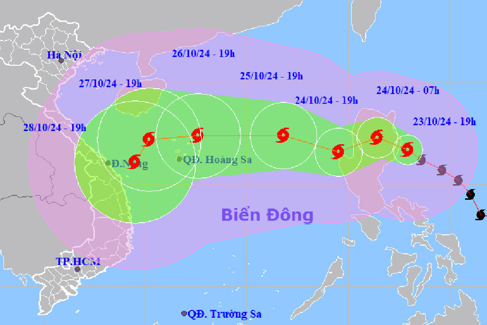
The National Center for Hydro-Meteorological Forecasting reported that as of 7 p.m. today (October 23), Typhoon TRAMI (known in Vietnamese as Trà Mi) was located over the eastern waters of Luzon Island, Philippines. The maximum wind speed near the storm’s center was Category 9-10 (75-102 km/h), with gusts up to Category 12. It is moving west-northwest at a speed of 15-20 km/h.
In the next 24 hours, Typhoon Trami is forecasted to move west-northwest, then potentially shift to a west-southwest direction at a speed of 15 km/h. By 7 p.m. tomorrow (October 24), the storm’s center will be over the eastern part of the northern East Sea, with maximum winds at Category 9 and gusts up to Category 11.
According to the meteorological agency, over the following 24 hours, the typhoon will continue moving west-northwest at 10-15 km/h. By 7 p.m. on October 25, Typhoon Trami’s center will be over the eastern waters of the northern East Sea, approximately 580 km east of the Hoang Sa (Paracel Islands), with wind intensity increasing to Category 10, and gusts up to Category 12.
On October 26, the storm is expected to further intensify, reaching Category 11-12 with gusts up to Category 15, and will change direction again to move westward at 15-20 km/h. The storm’s center at 7 p.m. will be over the northeastern waters of the Paracel Islands.
In the following 72 to 120 hours, the storm will mainly move westward at a speed of 10-15 km/h, with a possible shift to the south-southwest and a gradual slowdown.
Due to the influence of the typhoon, the eastern waters of the northern East Sea will experience strong winds at Category 6-7, and areas near the storm’s center will see winds of Category 8-9 (62-88 km/h), with gusts up to Category 11. Wave heights will reach 3-5 meters, and areas near the storm’s center will have waves as high as 5-7 meters, leading to very rough seas.
The meteorological agency has issued warnings for vessels operating in the dangerous areas, as they may face thunderstorms, strong winds, and large waves.
According to Vu Anh Tuan, Deputy Head of Weather Forecasting at the National Center for Hydro-Meteorological Forecasting, the impact of the storm may cause widespread heavy rain in the central provinces of Vietnam from October 26-28.
Bao Anh