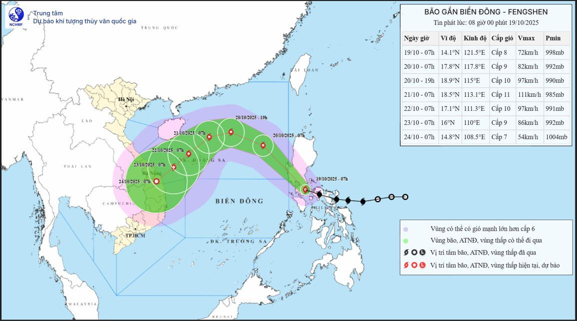
According to the National Center for Hydro-Meteorological Forecasting, as of 7 a.m. today (October 19), the storm’s center was located at approximately 14.1°N latitude and 121.5°E longitude, over the eastern region of central Philippines.
Maximum sustained winds near the storm's center were at level 8 (62-74 km/h), with gusts up to level 10. The storm is moving west-northwest at about 20 km/h.
Over the next 24 hours, Fengshen is projected to move northwestward at 20-25 km/h and enter the East Sea by this evening, becoming storm number 12. By 7 a.m. tomorrow (October 20), its center will be over the northeastern part of the East Sea, with wind speeds reaching level 9 and gusts at level 11, with potential for further intensification.
In the following 24 hours, the storm will continue moving northwest at 20 km/h. By 7 a.m. on October 21, its center will be over the northeastern part of the East Sea, about 220 km northeast of the Paracel Islands, with wind speeds at level 10-11 and gusts up to level 13.
In the next 24 hours, the storm is expected to change direction, heading west-southwest at about 10 km/h. By 7 a.m. on October 22, the storm will be located west of the Paracel Islands with sustained winds at level 10 and gusts reaching level 13.
From 72 to 120 hours afterward, Fengshen is forecast to continue moving southwestward at 10-15 km/h and gradually weaken.
Meteorologists highlight that as the storm enters the East Sea, it will encounter a cold air mass already present in the region.
This cold air mass, located to the west of the storm, will prevent it from moving directly westward toward northern Vietnam or into China, as both the north and west paths are blocked. Therefore, by the time the storm reaches the Paracel Islands, it will likely reach peak strength at level 11 with gusts at level 13 before being affected by cold air and weakening gradually.
Due to the combined influence of cold air and the storm’s circulation, the northeastern part of the East Sea will experience increasingly strong winds of level 6-7, while areas near the storm’s center will face winds at level 8-9 with gusts up to level 11 and waves between 2.5-5 meters. The sea will be extremely rough.
Between October 20-22, the northern East Sea (including the Paracel Islands) is expected to be impacted by strong winds at level 10-11 with gusts reaching level 13.
All vessels operating in the affected areas will face risks of thunderstorms, whirlwinds, strong winds, and high waves.
Additionally, due to the influence of the cold air combined with disturbances in the upper easterly winds, moderate to heavy rain with thunderstorms is expected today and tonight from Nghe An to Quang Ngai, with localized areas experiencing very heavy rain. Rainfall is forecast to ease starting October 20.
Bao Anh