A cold air front is forecast to strengthen and move southward by the night of November 27.
Lam explained that cold air is generally unfavorable for storm development, which is why Koto is likely to weaken. From November 29 onward, the storm is expected to decrease in strength to around level 9–10 by November 30 and December 1.
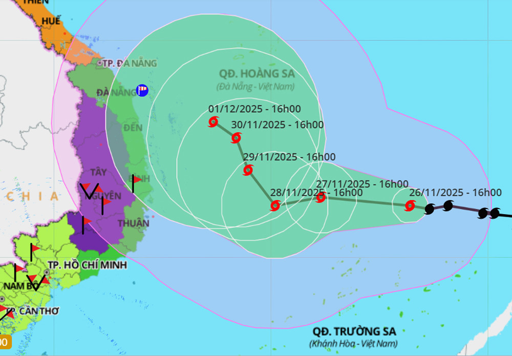
As Koto approaches longitude 112–113, the subtropical ridge weakens, reducing the steering influence and causing the storm to drift northward.
For the next 24 hours, the storm will remain over warm waters (27–28°C), supporting further development. However, as cold air enters and the storm reaches the 112–113E region, sea surface temperatures will drop, leading to weakening.
Additionally, Lam explained that the pressure difference created by the incoming cold front - where the cold air represents high pressure and the storm a low-pressure area - could initially increase wind speeds. However, as the cold air penetrates the storm’s circulation, it will begin to weaken.
“Storm Koto is considered highly complex, especially from the evening of November 28 onward. At that point, it is expected to slow to around 5 km/h, meaning it could linger for 5 to 7 days - until around December 2 or 3,” Lam warned.
Central Vietnam to brace for rain, landslide risk
Experts currently consider two possible scenarios for storm No.15:
The more likely scenario (80%) is that Koto veers northward as it approaches the northwestern sea area of the Spratly Islands, about 500 km east of the Gia Lai–Khanh Hoa coastline.
Upon reaching longitude 113E, the storm is projected to turn north and weaken into a tropical depression, eventually drifting toward the central mainland and further weakening at sea. This scenario suggests little to no direct wind impact on land.
However, widespread rain is still expected from Da Nang to Lam Dong in early December, with coastal areas facing the highest risk.
“Based on current data, the rain is unlikely to be as extreme as the recent downpour from November 16–21,” Lam added.
In the less likely scenario (20%), the storm fails to turn and heads west toward the Gia Lai–Khanh Hoa region. If this occurs, the storm could reach peak intensity at level 11, gusting to level 13, near the northern Spratly Islands, before moving westward toward the mainland and weakening to level 8 or a tropical depression.
In this case, the coastal provinces from Da Nang to Lam Dong could face strong winds (level 8, gusting to level 10), waves 3–5 meters high, and heavy rain totaling 150–250mm between November 29 and December 1.
Regardless of the scenario, experts emphasize the need for strict coastal bans on sea activities in affected regions. All vessels and fishing boats should be kept ashore to ensure safety.
Bao Anh