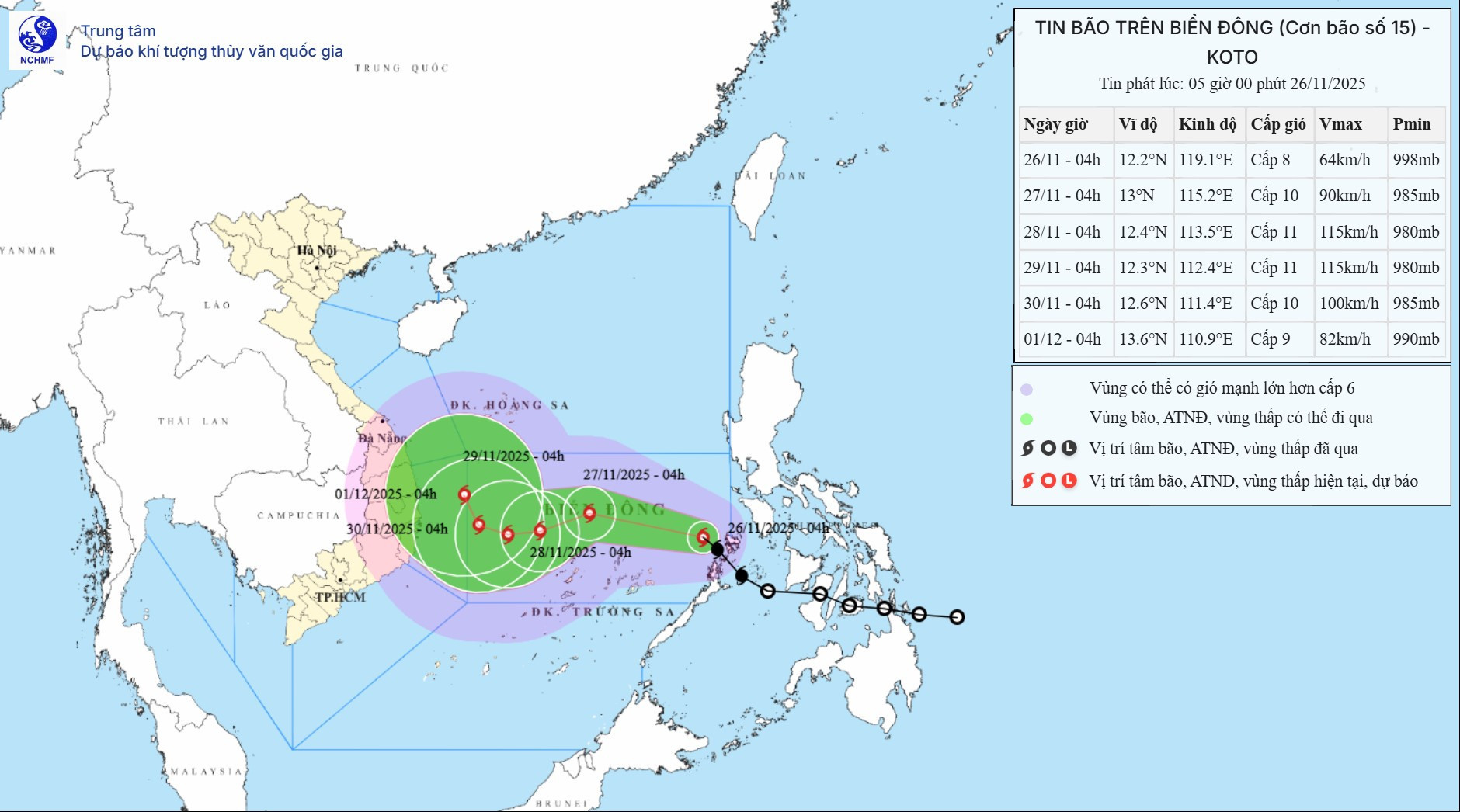
Forecast models remain divergent. However, experts from the NCHMF predict the storm will continue to strengthen after entering the East Sea. Its peak intensity could reach level 11, with gusts at level 14, as it moves between the Hoang Sa (Paracel) and Truong Sa (Spratly) archipelagos.
As steering systems shift, the storm's trajectory becomes increasingly uncertain. Meteorologists explain that the weakening of the subtropical high-pressure ridge, the emergence of a westerly trough at 5,000 meters altitude (which may steer the storm northward), and the arrival of cold air masses from the north all contribute to a complicated forecast. The storm may move directly toward central Vietnam, veer northward, or drift south.
In terms of impact on mainland Vietnam, experts say the storm’s landfall trajectory will determine its direct effects. Regardless, widespread moderate to heavy rainfall is expected between November 28 and 30, particularly from Hue to Lam Dong.
Initial assessments suggest rainfall intensity will be lower than the event that occurred in south-central Vietnam between November 16 and 22. The meteorological agency will continue updating forecasts as the situation evolves.
According to the latest bulletin, after entering the East Sea, storm No. 15 is expected to change direction several times. Within the next 24 hours, it will shift from a northwest to a west-northwest direction at a reduced speed of 15–20 km/h and likely increase in strength. By 4 a.m. tomorrow (November 27), the storm center will be over the central East Sea, about 200 km northeast of Song Tu Tay Island, with wind speeds reaching level 10 and gusts at level 13.
In the following 24 hours, the storm is expected to turn west-southwest and slow further to 5–10 km/h, while continuing to strengthen. By 4 a.m. on November 28, its center is projected to be 150 km northwest of Song Tu Tay Island, with maximum sustained winds at level 11 and gusts up to level 14.
Another 24 hours later, the storm will head west at just 5 km/h, maintaining its strength. By 4 a.m. on November 29, it is expected to be 250 km west-northwest of Song Tu Tay Island in the western part of the central East Sea.
Between 72 and 120 hours from now, storm Koto will move northwest at a slow pace of approximately 5 km/h and gradually weaken.
Due to the storm's influence, the central East Sea - including northern waters of the Truong Sa archipelago - will experience strong winds at levels 6–7. Areas near the storm center will see winds at levels 8–10, with gusts reaching level 13. Sea waves in these areas will rise to 4–6 meters, and 6–8 meters near the center, resulting in extremely rough seas.
Around November 27–28, the central East Sea (including northern waters of the Truong Sa archipelago) could be affected by winds at level 11, gusting to level 14, with waves reaching heights of 7–9 meters and very dangerous sea conditions.
Vessels operating in these hazardous zones may encounter thunderstorms, waterspouts, strong winds, and large waves.
Bao Anh