 |
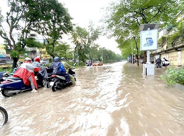
| Huỳnh Thúc Kháng Street in Hà Nội is submerged after heavy rain. — VNA/VNS Photo Vũ Sinh |
Typhoon Yagi has left many serious consequences in the northern region with flooding not just claiming lives but also destroying livelihoods and it happened in many diverse areas, regardless of whether they were in the mountains or on lower ground.
Experts said that climate change was becoming more and more complex and flooding in large cities was occurring more frequently, both in the rainy and dry seasons, affecting people’s life.
In spite of many flood prevention projects worth trillions of đồng (VNĐ1 trillion equals US$40.5 million) those plans were not able to save the city from being submerged when heavy rains last for a long time.
The requirement for urban construction and development to adapt to climate change and prevent flooding is becoming increasingly urgent. However, it is very difficult to immediately have a solution that can fully do away with the problem.
Architect Ngô Viết Nam Sơn believes that in addition to urbanisation not being synchronised with flood prevention solutions, many natural rivers and canals are being encroached and filled in to build houses and create urban areas, narrowing the natural drainage space, so creating areas prone to flooding.
To combat floods in a sustainable way, city authorities need to be consistent in planning and licensing urban projects, especially areas along rivers, canals and ditches.
Ultimately, drainage will not be effective if the river and canal systems are encroached upon or filled.
HCM City is cited by Sơn as having filled in canals for decades to make box culverts, which have a large and strong drainage capacity, allowing for easier dredging and maintenance.
But, he said, in essence nothing would ever replace the canals, which in addition to being able to hold a large amount of water, can also take away groundwater, effectively becoming a very large water reserve.
Similarly, in Hà Nội, many streets turn into rivers whenever there is heavy rain, proving a major headache for management agencies.
According to the municipal Department of Transport, there are currently 30 'black spots' in the capital city that predictably become inundated when heavy rains occur, such as Nguyễn Khuyến Street, Hoa Bằng Street, Phan Bội Châu-Lý Thường Kiệt intersection, Minh Khai Street, and Thăng Long Avenue.
Deputy President of the Việt Nam Urban Planning and Development Association Đào Ngọc Nghiêm said that the reason why the capital flooded every time it rained was because the sewer and drainage system had many limitations.
Hà Nội is divided into three areas for drainage, the north Hà Nội area, the left Đáy River area and the right Đáy River area.
However, the pumping stations to pump water downstream have not been built. In addition, the downstream pumping stations do not have enough capacity.
Nghiêm shared the experience of countries around the world in preventing and combating flooding, showing that from 3 to 5 per cent of the land surface must be used as regulating lakes.
But, Hà Nội now only has about 2 per cent, equivalent to 6,000ha of lakes.
Although the capital city has many canal systems, many of them have been filled in and the system’s full potential has not been exploited.
It can be seen that flood prevention projects in urban areas across the country are very necessary but not enough, especially with the present extreme weather changes.
Solutions
 |
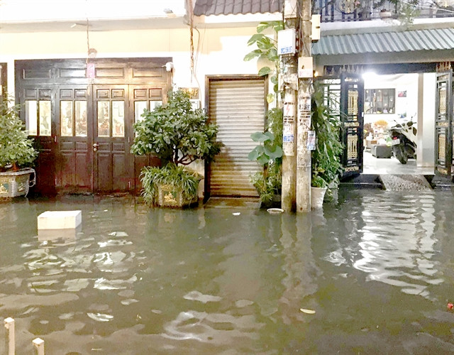
| Flooding in District 7 in HCM City. — VNA/VNS Photo Hồng Giang |
Solving the flooding situation requires a strategy and a sustainable vision.
For HCM City, experts advise that it is necessary to re-evaluate the effectiveness of flood prevention projects implemented in the past, both to draw lessons for future projects and to control the work results.
At the same time, the city should strengthen cooperation and share experiences with other cities around the world. From there, it is possible to minimise the impact of flooding and move towards a more sustainable future for the people and community.
As for Hà Nội, Nghiêm said that the best way was to quickly adjust drainage projects.
In addition, it is necessary to regularly maintain and repair the system of canals, ditches and sewers.
In particular, the capital city needs a policy to comprehensively study the river system flowing through Hà Nội.
At present, Hà Nội is conducting a number of projects, such as drainage systems, regulating lakes, upgrading and building pumping stations, improving the drainage system in the western area.
Along with that, a series of projects are being prepared for investment, such as the rainwater drainage system in the left basin of the Nhuệ River and the drainage system in Hà Đông District in the right basin of the Nhuệ River.
Three drainage projects invested by the Long Biên District People's Committee have all been approved by the Hà Nội People's Committee.
Climate change and flooding do not only occur in central cities but has spread throughout all regions.
To prevent natural disasters, Việt Nam has issued many related policies, strategies and programmes, aiming to respond to climate change and develop sustainable urban areas.
However, adaptation to climate change in urban planning still has limitations.
Director of the Department of Science, Technology and Environment under the Ministry of Construction Vũ Ngọc Anh said that to be resilient to climate change, urban areas should have moderate size and have sufficient adaptive capacity.
Việt Nam will be soon needing to approve the urban and rural planning system for the 2021-30 period, with a vision to 2050.
At the question-and-answer session before the National Assembly in June this year regarding flooding in urban areas, Minister of Construction Nguyễn Thanh Nghị also proposed a number of solutions.
The first one is to improve the laws related to drainage and wastewater treatment, including developing the Law on Urban and Rural Planning, the Law on Water Supply and Drainage, and the Law on Urban Development Management.
He also affirmed that it was necessary to improve the construction planning and urban planning management quality. — VNS