 Vietnamnet.vn

 Podcast



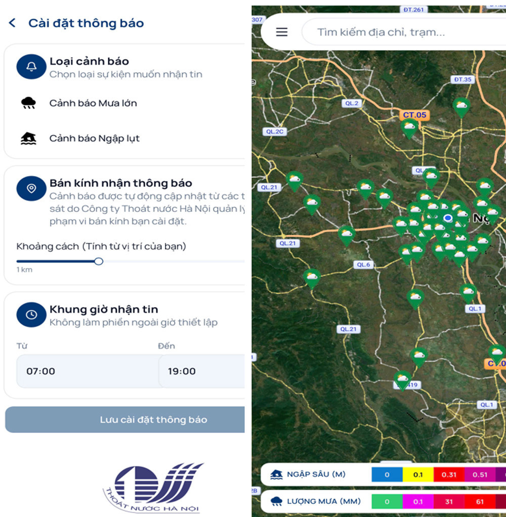
Vietnam is among the countries most severely affected by climate change and natural disasters. In Hanoi, sudden heavy downpours frequently cause localized flooding, directly affecting traffic safety and residents’ daily lives.
As part of efforts to use technology to improve public safety during adverse weather, the Hanoi Department of Science and Technology has officially launched the “Rain and Flood Map” mini app on iHanoi, the capital’s digital citizen super app, which currently has more than 6.4 million user accounts.
Rather than relying on scattered information or broad weather forecasts, the “Rain and Flood Map” provides residents with an official live stream of data. All information is drawn directly from an automated monitoring network managed and operated by Hanoi Sewerage and Drainage Company Limited (HSDC). Rainfall conditions and floodwater depths are continuously updated in real time, with rainfall measured in millimeters and water depth in meters.
According to the Hanoi Department of Science and Technology, the “Rain and Flood Map” mini app offers residents greater convenience through a range of personalized features. Its digital map uses a standardized color scale, allowing users to assess potential danger within seconds.
With multiple map layers and flexible search options, the mini app allows users to switch between street, light, dark and satellite views, while searching by address, street name or specific monitoring station.
When users tap a particular rain or flooding point on the map, a pop-up displays detailed information including the location name, address, rainfall and flooding level. The feature allows residents to immediately plan a safer route and avoid potentially dangerous areas.
The app also provides proactive alerts sent directly to users’ phones, meaning they do not need to have the app open to receive notifications. When flooding or heavy rainfall is detected within a designated area, the system automatically displays a detailed alert, helping residents quickly adjust their routes.
Users can customize the alert radius from 1 km to 100 km from their current location and set specific times for receiving notifications to avoid being disturbed outside their preferred hours or at night.
Notably, the mini app was designed with privacy transparency in mind, clearly explaining permissions for location access and notifications. The basic map lookup function remains available even when users have not granted location permission.
Hanoi’s launch of the “Rain and Flood Map” on iHanoi is expected to deliver a range of benefits to the community, from helping residents avoid accidents caused by floodwater obscuring manholes and potholes to reducing vehicle repair costs resulting from stalled engines and property damage. It can also help ride-hailing drivers, delivery workers, transport companies and residents plan and adjust their routes more effectively.
PV
.svg)
