 Vietnamnet.vn

 Podcast



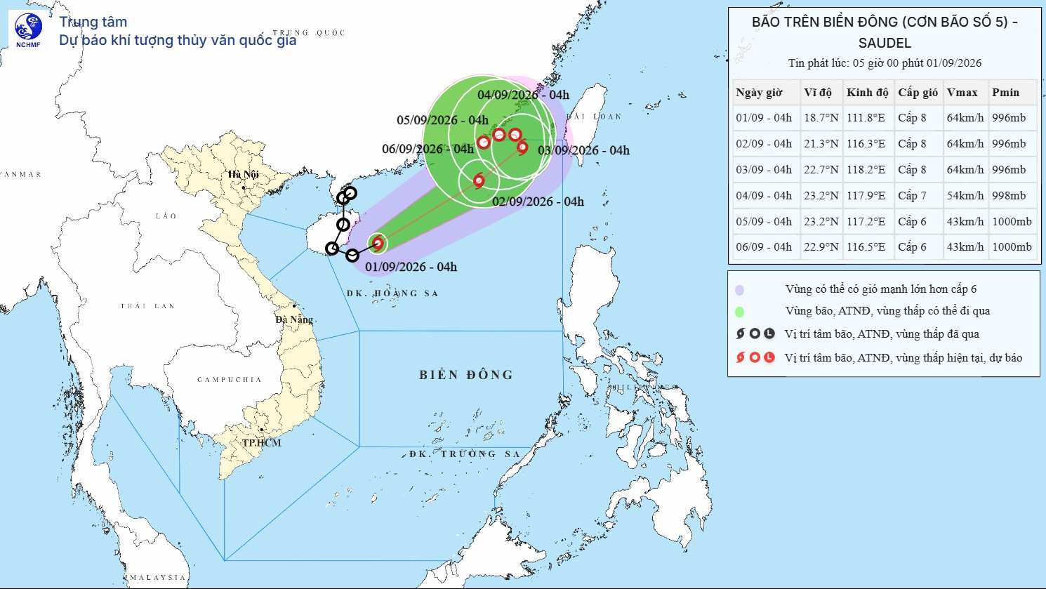
According to the National Center for Hydro-Meteorological Forecasting, the tropical depression over the western waters of the northern East Sea strengthened into a storm early Tuesday morning, Sept. 1, becoming the fifth storm in the East Sea this year. Its international name is Saudel.
At 4 a.m., the center of the storm was located at around 18.7 degrees north latitude and 111.8 degrees east longitude, over the western waters of the northern East Sea, about 240 km north of Vietnam’s Hoang Sa archipelago.
The strongest winds near the storm’s center were 62-74 kph, with gusts of 89-102 kph. It was moving northeast at 15-20 kph.
Saudel’s strengthening from a tropical depression means the storm has effectively been “reborn” over the East Sea.
Saudel had previously been active over the northwestern Pacific, where it strengthened into a storm and moved toward China. After making landfall and moving deeper inland, it weakened into a low-pressure area.
On the morning of Aug. 31, the low-pressure area moved into waters east of China’s Leizhou Peninsula, reorganized and strengthened into a tropical depression before intensifying once again into a storm.
Storm continues northeastward
From now through Sept. 4, the storm is forecast to move northeastward, heading farther out to sea without affecting Vietnam’s mainland.
Over the next 24 hours, it is expected to continue northeast at 20-25 kph. By 4 a.m. on Sept. 2, its center is forecast to be over the northeastern waters of the northern East Sea, with sustained winds of 62-74 kph and gusts of 89-102 kph.
During the following 24 hours, the storm is expected to maintain its northeastward course at 15-20 kph. By 4 a.m. on Sept. 3, its center will remain over the northeastern waters of the northern East Sea, with its intensity largely unchanged.
The storm is then forecast to turn north-northwest and slow to 3-5 kph while gradually weakening into a tropical depression.
By 4 a.m. on Sept. 4, the center of the tropical depression is forecast to be over waters south of China’s Fujian Province, with sustained winds of 50-61 kph and gusts of 75-88 kph.
Over the following 72 to 120 hours, the tropical depression is expected to turn mainly westward at 3-5 kph and continue weakening.
Under the influence of the storm, the northern East Sea, including the waters around the Hoang Sa archipelago, is forecast to experience winds of 39-61 kph, gusting to 62-88 kph, with waves of 2-4 meters.
Areas near the storm’s track could see sustained winds of 62-74 kph, gusts of 89-102 kph and waves of 3-5 meters, creating very rough seas.
Vessels operating in these hazardous areas could be affected by thunderstorms, tornadoes, strong winds and high waves.
Bao Anh
.svg)
