According to the National Center for Hydro-Meteorological Forecasting, both the storm and the tropical depression have quickly weakened under the impact of cold air.
As of 7:45 AM today (October 23), Storm No. 12 (Fengshen) has dissipated at sea, and the rainfall it caused has significantly reduced. The tropical depression in the East Sea is also expected to weaken rapidly and is unlikely to move inland.
Early this morning, after entering the coastal waters between Hue and Da Nang, the tropical depression (previously Storm No. 12) weakened into a low-pressure area.
At 7:00 AM, the center of this low-pressure area was located at approximately 16.1 degrees North latitude and 108.5 degrees East longitude. The strongest winds near the center have dropped below level 6 (less than 39 km/h). In the next 12 hours, this low-pressure area will continue to move southwest, gradually weakening and dissipating. This is the final bulletin regarding Storm No. 12.
However, meteorological experts warn that due to the combined influence of strengthening cold air, easterly wind disturbances, and the storm’s circulation, heavy rainfall in central Vietnam and strong winds at sea may still occur. People are advised to closely follow upcoming forecasts for heavy rain and strong winds at sea.
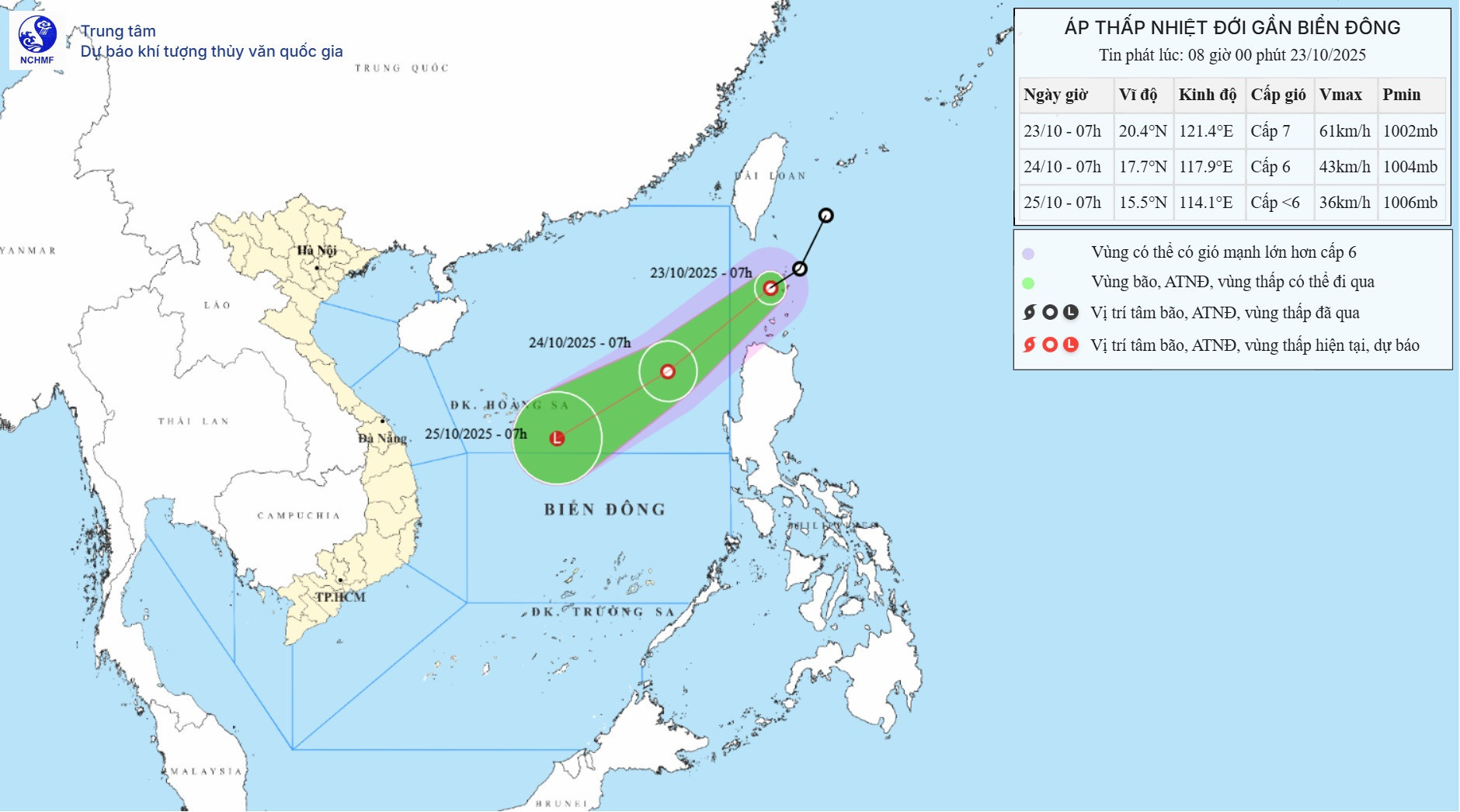
Regarding the tropical depression heading toward the East Sea, as of 7:00 AM today, its center was located at approximately 20.4 degrees North latitude and 121.4 degrees East longitude. The strongest winds near its center reached level 7 (50-61 km/h), with gusts up to level 9. It is moving southwest at a speed of about 20 km/h.
Over the next 12 hours, the tropical depression will continue moving south-southwest at approximately 20 km/h, entering the East Sea. By 7:00 AM tomorrow (October 24), its center will be located over the eastern waters of the northern East Sea, with wind speeds at level 6 and gusts up to level 8.
In the subsequent 12 hours, the tropical depression will continue moving southwest at the same speed. By 7:00 AM on October 25, it is expected to be about 250 km east of the Hoang Sa (Paracel) Archipelago and will have weakened into a low-pressure area.
Due to the combined effects of the strengthening cold air, the eastern region of the northern East Sea is experiencing strong winds at levels 6-7, with gusts reaching level 9. Sea waves are 3-5 meters high, resulting in rough sea conditions.
Vessels operating in these hazardous areas may be affected by thunderstorms, whirlwinds, strong winds, and high waves.
Bao Anh