Meteorologists have identified two potential paths for the storm, depending on the behavior of the subtropical ridge as Matmo approaches Guangdong (China).
The first scenario, with a probability of 70–75%, assumes a rapid weakening and eastward retreat of the subtropical high, causing the storm to veer further north and move more inland - similar to the path of storm No. 9.
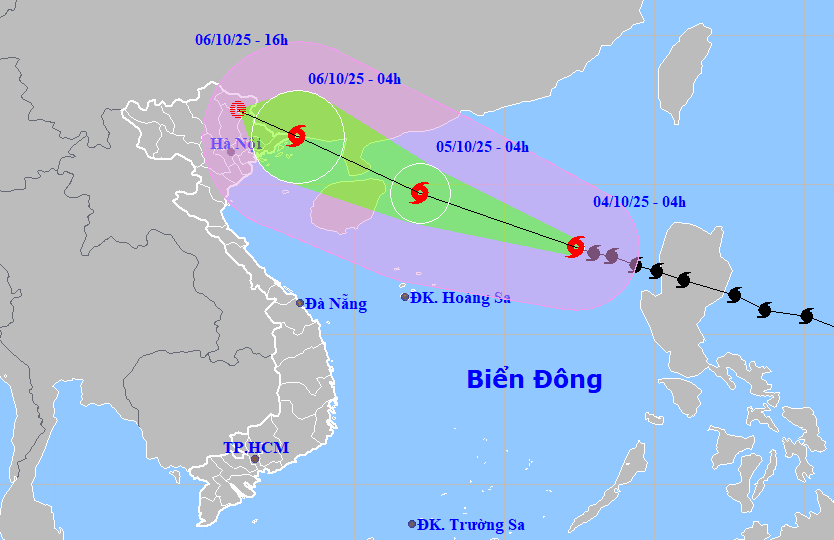
In this scenario, Matmo would weaken by 2–4 levels by the time it reaches northern Quang Ninh province. In the Gulf of Tonkin, wind speeds could reach level 9–10, and on land in Quang Ninh and Hai Phong, winds could reach level 8–9, accompanied by heavy to very heavy rainfall across northern Vietnam, especially in the midland and mountainous areas.
The second, more extreme scenario (25–30% probability), assumes the subtropical high weakens insignificantly, causing Matmo to stay mostly over the sea and retain more of its strength. In this case, the storm would reach Quang Ninh–Hai Phong with stronger intensity, potentially bringing winds of level 9–10 and gusts at levels 12–14.
Under this scenario, the area affected by strong winds would extend further south to include Ninh Binh. Heavy rain would increase, and the wind impact zone would penetrate deeper inland into the plains and Thanh Hoa province.
Heavy rainfall from the North to Nghe An, risk of flooding rises
In the northern East Sea, wind speeds are expected to reach levels 8–10, and near the storm center, levels 11–13 with gusts up to level 16. Wave heights could reach 13–20 feet, and near the eye of the storm, 20–26 feet, creating extremely rough seas with a high risk of severe maritime damage, including the potential sinking of large vessels.
From the afternoon of October 5, the eastern part of the northern Gulf of Tonkin (including the Bach Long Vi archipelago) will begin to experience winds at level 6–7, later increasing to level 8–9. By the evening, strong winds of level 8–9 will affect areas including Bach Long Vi, Van Don, Co To, Cat Hai, and Hon Dau islands, with the storm center passing nearby at levels 10–11, gusting to level 14. Wave heights may reach 10–16 feet, creating extremely dangerous maritime conditions.
Due to the storm, coastal and island areas of Quang Ninh and Hai Phong provinces may experience storm surges of 1.3–2 feet. Low-lying coastal and river estuary regions are at risk of flooding due to storm surges and large waves starting from the afternoon and evening of October 5.
Meteorological agencies warn that coastal mainland areas affected by the storm are extremely hazardous and unsafe for any operations, including passenger and cargo ships, fish cages, aquaculture areas, dikes, embankments, and coastal roads. All equipment and vessels in these zones are at high risk of capsizing or destruction due to strong winds, high waves, and storm surges.
From the night of October 5, strong winds are expected on land from Quang Ninh to Ninh Binh, reaching levels 6–8, and in areas near the storm center, levels 9–10. These wind speeds can topple trees, damage homes, utility poles, and cause serious destruction. Inland areas of northeastern Vietnam may also experience winds at level 6, with some places reaching level 7 and gusts up to level 9.
From the night of October 5 to the end of October 7, northern Vietnam, Thanh Hoa, and Nghe An will experience heavy to very heavy rainfall, with total precipitation ranging from 4–8 inches, and locally exceeding 12 inches. In mountainous and midland areas, rainfall could range from 6–10 inches, with some areas exceeding 15.5 inches. There is a warning for extremely intense rainfall events (over 8 inches within 3 hours).
Additionally, from October 6 to 9, rivers across northern Vietnam, Thanh Hoa, and Nghe An are expected to see flooding, with peak water levels reaching or exceeding level 2–3 flood alerts.
Bao Anh