Storm No. 15 is forecast to form over the East Sea around November 26. At the same time, a cold air front is expected to intensify around November 26–27 and again on November 30. The interaction between these two systems could produce unpredictable weather patterns.
According to the National Center for Hydro-Meteorological Forecasting, beginning tonight (November 24), cold air will begin affecting the northeastern and north-central regions of Vietnam, and later spread to the northwest and central-central regions. Northeasterly winds are forecast at level 3–4, reaching level 4–5 along the coast.
In the northern and north-central regions, the weather will generally remain dry and cold, with severe cold possible in mountainous areas. High-altitude areas in the north are at risk of frost.
The lowest temperatures during this cold spell in northern and north-central Vietnam will range from 12–15°C, with some mountainous locations dropping below 10°C.
In Hanoi, the weather is expected to remain dry overnight, sunny during the day, and cold, with lows between 13–15°C.
Additionally, due to the combined effects of cold air and disturbances in the upper easterly wind belt, areas from Hue and Da Nang to eastern Quang Ngai will likely experience rain and scattered thunderstorms tonight and on November 25.
The Southern Hydro-Meteorological Station has also issued a forecast indicating that cold air will intensify between November 24–25, stabilize briefly, and then strengthen again around November 26–27 and November 30.
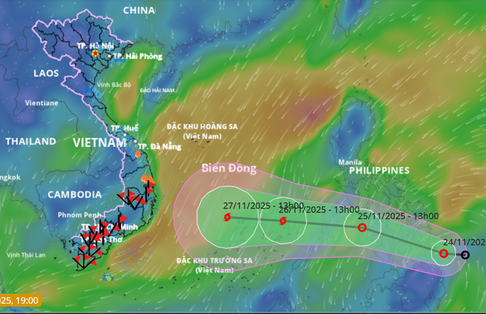
At the same time, an equatorial trough between 5–8°N is connected to a tropical depression currently located east of the central Philippines. By the night of November 25, this depression is expected to enter the East Sea and potentially strengthen into Storm No. 15.
Experts from the National Center for Hydro-Meteorological Forecasting believe that by November 26, when the depression is still about 1,000 km from the south-central coast of Vietnam, it may intensify into a tropical storm.
The storm could reach its peak intensity as it passes north of the Truong Sa (Spratly) Archipelago, with wind levels reaching 10 and gusts up to level 13. It is then expected to move westward toward the mainland, primarily impacting areas from Gia Lai to Lam Dong (covering the old provinces from Binh Dinh to Binh Thuan), with the main period of influence expected between November 28–30.
Initial forecasts suggest the storm’s intensity may decrease as it nears the coast, influenced by colder air and lower sea surface temperatures in the South Central waters.
By the time it makes landfall, the storm may be downgraded to levels 8–9 or even to a tropical depression. Between November 28–30, areas from Da Nang to Lam Dong are expected to experience widespread heavy rainfall, particularly along the coastal strip.
As of 7:00 PM on November 24, the tropical depression’s center was located over central Philippines. The strongest winds near the center were at level 7 (50–61 km/h), gusting up to level 9. The system is moving west-northwest at 20–25 km/h.
Bao Anh