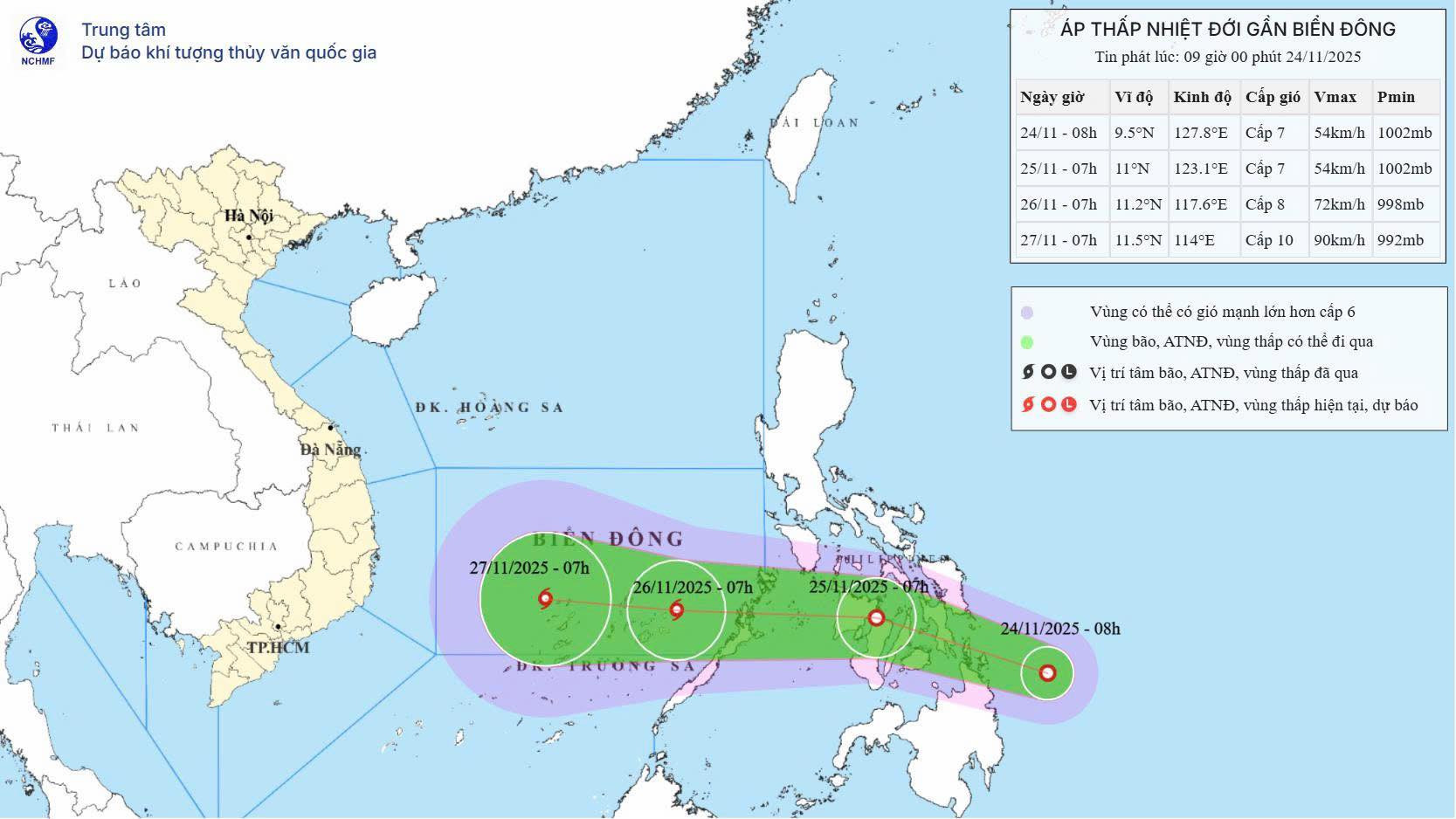
According to the National Center for Hydro-Meteorological Forecasting, early on November 24, a tropical depression formed over the eastern waters of the Philippines. As of 8 a.m., the center of the system was located east of central Philippines.
Meteorologists forecast that the depression will move west-northwest at a speed of around 20km/h over the next one to two days.
By the night of November 25 or early morning of November 26, it is expected to enter the East Sea and may intensify into Tropical Storm Fifteen.
When the storm is about 1,000 km off the south-central Vietnamese coast on November 26, its peak winds could reach level 10 (up to 102 km/h), with gusts up to level 13. From there, it is projected to continue moving west toward land, with potential landfall impacts from Gia Lai to Lam Dong, including coastal provinces from Binh Dinh to Binh Thuan.
Initial forecasts suggest that as the storm approaches Vietnam’s coast, it may weaken due to cold air and lower sea surface temperatures in the south-central waters.
“The storm’s intensity when it reaches land is expected to be around level 8–9 or remain a tropical depression,” a weather expert stated.
Between November 28 and 30, the region from Da Nang to Lam Dong may experience widespread heavy rainfall, with the heaviest rain expected along the coastline.
The forecasting center emphasized that the storm's exact impacts will depend on evolving meteorological data and should be monitored closely in the coming days.
Storm progress and impact timeline
Over the next 24 hours, the depression will move west-northwest at 20–25 km/h, reaching central Philippines by 7 a.m. on November 25, with wind speeds of level 7 and gusts at level 9.
In the following 24 hours, the system may strengthen into a storm, enter the East Sea, and by 7 a.m. on November 26, be located in the southeastern part of the central East Sea, with wind speeds increasing to level 8 and gusts up to level 10.
Over the next 48 to 72 hours, the storm will continue heading west at 15–20 km/h and could strengthen further.
From the evening of November 25, winds in the eastern and southern parts of the East Sea are expected to strengthen to level 6–7, with areas near the center reaching level 8 and gusting to level 10. Waves could rise between 3–5 meters, and rough seas are expected.
Between November 26 and 28, the central and southern parts of the East Sea - including the northern area of the Spratly Archipelago - will likely experience gale-force winds of level 9–10 and gusts up to level 13.
Marine vessels in affected areas are warned of possible thunderstorms, whirlwinds, strong winds, and high waves.
Cold front to bring rain and cold to central Vietnam
The national forecasting center also reported that a cold air mass is expected to reach northeast and north-central Vietnam this evening, later spreading to the northwest and central regions. Northeasterly winds will strengthen to level 3–4, and coastal areas may see winds up to level 5.
In northern and north-central Vietnam, dry weather is expected with cooler temperatures starting November 25. Mountainous areas could see temperatures drop below 10°C. In Hanoi, sunny days and dry, cold nights are forecast, with lows between 13–15°C.
Due to the interaction between this cold air and high-altitude disturbances, areas from Hue and Da Nang to eastern Quang Ngai will see moderate to heavy rain today and tonight, with some locations receiving over 120mm of rain in 24 hours.
In parts of Gia Lai, Dak Lak, and northern Khanh Hoa, scattered showers and thunderstorms will bring 15–30mm of rain, with isolated areas receiving more than 60mm. Rainfall is expected to ease in the central region after November 25.
Heavy rain could cause localized flooding in low-lying areas, flash floods on small rivers and streams, and landslides on steep slopes.
From the afternoon of November 24, the Gulf of Tonkin will experience northeast winds strengthening to level 6, with gusts up to level 8 and wave heights of 2–4 meters. The northern East Sea will see winds reach level 7, gusting to level 9, with waves up to 6 meters and rough seas.
By this evening, winds from southern Quang Tri to Ca Mau and across the central East Sea will also strengthen, with gusts up to level 9 and waves up to 5 meters.
Bao Anh