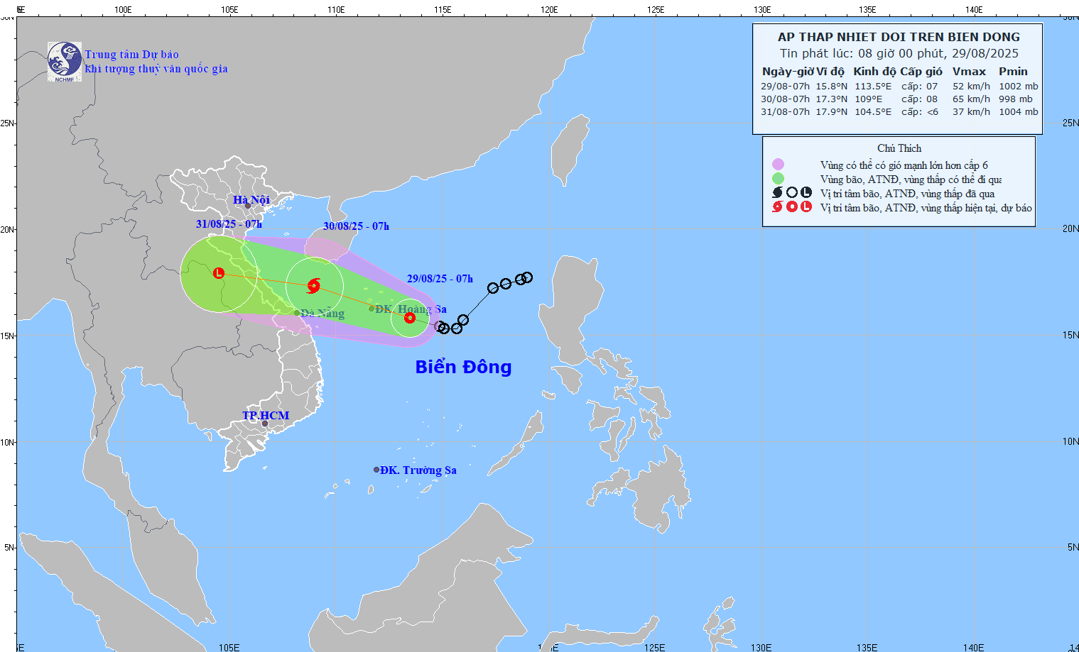
According to the National Center for Hydro-Meteorological Forecasting, as of 7:00 a.m. on August 29, the storm's center was located in the southeast sea area of the Hoang Sa (Paracel) archipelago. Maximum sustained winds near the center reached 39–61 km/h (level 6–7), with gusts up to level 9. The system is moving northwest at around 15 km/h.
Meteorologists forecast that the depression could strengthen to level 8 (tropical storm status) within 24 hours, although further intensification to level 9 is unlikely. Once the system nears the shoreline, it is expected to begin weakening.
Due to the westward tilt of the storm’s cloud mass, increased rainfall is forecast to begin over land and coastal areas as early as this afternoon. The heaviest downpours are expected during the night of August 30 and early morning of August 31.
By 7:00 a.m. on August 30, the tropical system is predicted to be located over waters between Nghe An and Hue, possibly intensifying into Storm No. 6 with winds reaching level 8 and gusts up to level 10. Should it be named, this would be the sixth tropical storm to form in the East Sea in 2025.
The storm is projected to continue moving west-northwest at 20–25 km/h and weaken over central Laos by the morning of August 31.
Warnings for sea areas and coastal provinces
The western part of the northern East Sea, including the Hoang Sa archipelago, is forecast to see strong thunderstorms, winds at level 6–7, gusting up to level 10, and sea waves reaching 2.0–5.0 meters - resulting in rough seas.
From the evening of August 29, coastal areas from Nghe An to Hue (including Hon Ngu Island and Con Co Island) are expected to experience increasingly strong thunderstorms and winds at level 6–7, possibly reaching level 8 near the storm’s center. Gusts could reach level 10, with waves between 2 and 5 meters.
All vessels operating in these hazardous zones may face dangerous conditions, including strong winds, rough seas, thunderstorms, and waterspouts.
The Ministry of Agriculture and Environment has issued urgent instructions to provinces and cities from the North to Da Nang, urging prompt recovery from the impacts of Storm No. 5 and proactive preparation for potential flooding, landslides, and waterlogging caused by heavy rain.
Recent days have already seen heavy rainfall in northern and north-central Vietnam due to the remnants of Storm No. 5, leading to flooding, landslides, and significant damage to people, property, and infrastructure.
From the evening of August 29 through August 31, rainfall totals are expected to range between:
150mm–350mm across Thanh Hoa to Hue, with some localities exceeding 600mm
100mm–200mm in the Red River Delta, midlands, and Da Nang, with isolated areas reaching over 400mm
The intense rainfall may cause flash floods in mountainous areas, landslides on steep terrain, and urban flooding in low-lying or industrial zones.
To address the impending threat, the Ministry of Agriculture and Environment has called on provincial authorities to:
Mobilize resources to assist in recovery from Storm No. 5
Closely monitor forecasts and early warnings for extreme weather
Promptly inform local authorities and residents so they can prepare and evacuate if necessary
Coordinate with disaster response units to ensure swift action in the event of flooding, landslides, or infrastructure failures
Bao Anh