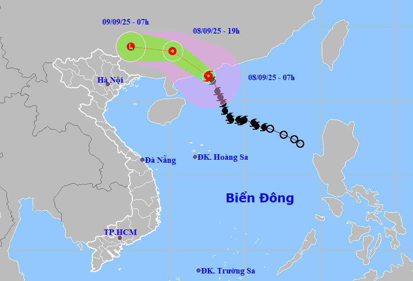
According to the National Center for Hydro-Meteorological Forecasting, as of 7 a.m. on September 8, the storm was located offshore near Guangdong with level 11 winds and gusts of level 13. It is moving northwestward at 20-25 km/h and will likely hit land this morning before gradually weakening.
In the next 12 hours, the storm is forecast to shift slightly northwest, continuing at 20-25 km/h and weakening into a tropical depression. By 7 p.m., its center will be over Guangxi Province, China, with sustained winds down to level 7 and gusts of level 9.
In the following 12 hours, it will move west-northwest and further degrade into a low-pressure system over Guangxi.
Meteorologists warn that although Vietnam will not be directly impacted by the storm’s core, its outer bands may still affect regions such as the Gulf of Tonkin and the eastern coastal areas of northern Vietnam. Thunderstorms, whirlwinds, and strong gusts could occur.
From September 9 to the night of September 10, mountainous and midland regions of northern Vietnam are expected to experience widespread rainfall, ranging from 70 to 150 mm. In some places, rainfall could exceed 300 mm. There is also a risk of intense downpours, exceeding 100 mm in just three hours, along with lightning, hail, and strong gusts.
Starting September 11, as the tropical depression dissipates, rainfall in the north will begin to ease. From September 12 to 14, the weather will become dry and cooler.
Due to the storm’s influence, the northern sector of the East Sea is experiencing strong winds of level 7-8, with areas near the center reaching level 10-11 and gusts of level 13. Waves are ranging from 4 to 6 meters, and the sea is extremely rough. All vessels in affected areas face a high risk of thunderstorms, whirlwinds, strong winds, and high waves.
This marks the seventh tropical storm in the East Sea so far this year. Forecasts suggest that between now and the end of the year, the region could see 5 to 7 additional storms or tropical depressions. Of these, 2 to 3 may directly impact mainland Vietnam, mostly affecting central and southern provinces.
Bao Anh