According to the National Center for Hydro-Meteorological Forecasting, Storm Trami is predicted to linger off the coast of Central Vietnam for over 24 hours, starting from October 27, with wind speeds ranging from levels 9 to 10 and changing direction multiple times. Heavy rain is expected across the region from Ha Tinh to Quang Ngai.
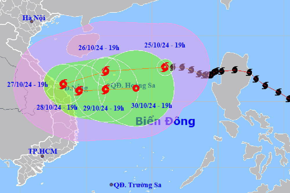
As of 7 p.m. on October 25, the storm's center was located over the northeastern section of the North East Sea, about 410 kilometers east-northeast of the Hoang Sa Archipelago. The maximum wind speeds near the storm's center were between 89-102 km/h, with gusts up to level 12. The storm was moving westward at a speed of approximately 20 km/h.
Over the next 24 hours, Storm Trami will maintain its westward movement and intensity, peaking at levels 11-12 with gusts reaching level 15. By 7 p.m. on October 26, the storm is expected to be located north of the Hoang Sa Archipelago.
By 7 p.m. on October 27, the storm will shift direction, moving west-southwest at a speed of 15 km/h, with its center positioned near the coastal waters of Central Vietnam, and its intensity reducing to level 10 with gusts up to level 12.
In the following 24 hours, the storm will turn to move south-southwest, then east-southeast at a speed of 5-10 km/h. By 7 p.m. on October 28, the storm is forecasted to remain off the coast of Central Vietnam, further weakening to level 9 with gusts up to level 11.
From 72 to 120 hours later, the storm is expected to move primarily eastward, slowing down to 5-10 km/h and continuing to weaken.
Due to the storm's impact, the northern section of the East Sea will experience winds ranging from levels 8-9, with areas near the storm's center reaching levels 10-12 (89-133 km/h) and gusts up to level 15. Wave heights will range from 5-7 meters, and up to 7-9 meters near the storm's core, resulting in rough seas.
Beginning early on October 27, the coastal waters from Quang Binh to Quang Ngai, including Con Co, Cu Lao Cham, and Ly Son islands, will experience increasing winds, reaching levels 6-7 and potentially rising to levels 8-9. Areas near the storm's center may see winds at levels 10-11 with gusts up to level 14. Wave heights are forecasted to be 3-5 meters, with 5-7 meters closer to the storm's core.
Meteorologists have also issued warnings of potential storm surges of 0.4 to 0.6 meters along the coast from Quang Tri to Quang Nam, starting from October 27.
Vessels operating within the storm-affected areas, especially near the Hoang Sa Archipelago and the coastal waters from Quang Binh to Quang Ngai, are at risk of thunderstorms, strong winds, and high waves.
The authorities have issued alerts for high risks of erosion and damage to dykes and coastal structures from Quang Tri to Quang Nam due to high waves and storm surges.
On land, strong winds will begin to impact the coastal areas from Quang Binh to Quang Ngai from October 27, with winds ranging from levels 6-7 and up to levels 8-9 near the storm's core, with gusts reaching level 11.
The storm's circulation is expected to bring heavy rainfall from the evening of October 26 through October 28. Areas from Quang Tri to Quang Ngai could see rainfall between 300-500 mm, with localized areas experiencing more than 700 mm.
Heavy rainfall (>100 mm/3 hours) may occur in localized areas. Ha Tinh, Quang Binh, Binh Dinh, and northern Central Highlands regions could also experience significant rainfall, ranging from 100-200 mm, with isolated areas receiving more than 300 mm.
Given the complex and potentially changing nature of the storm, residents are advised to stay updated through subsequent storm forecasts.
Bao Anh