Over the next 24 hours, Typhoon Trami could reach a maximum intensity of Category 12, with gusts up to Category 15. In the Hoang Sa (Paracel) Islands, the storm's movement is being influenced by cold air and a new storm system, leading to an 'unusual' trajectory.
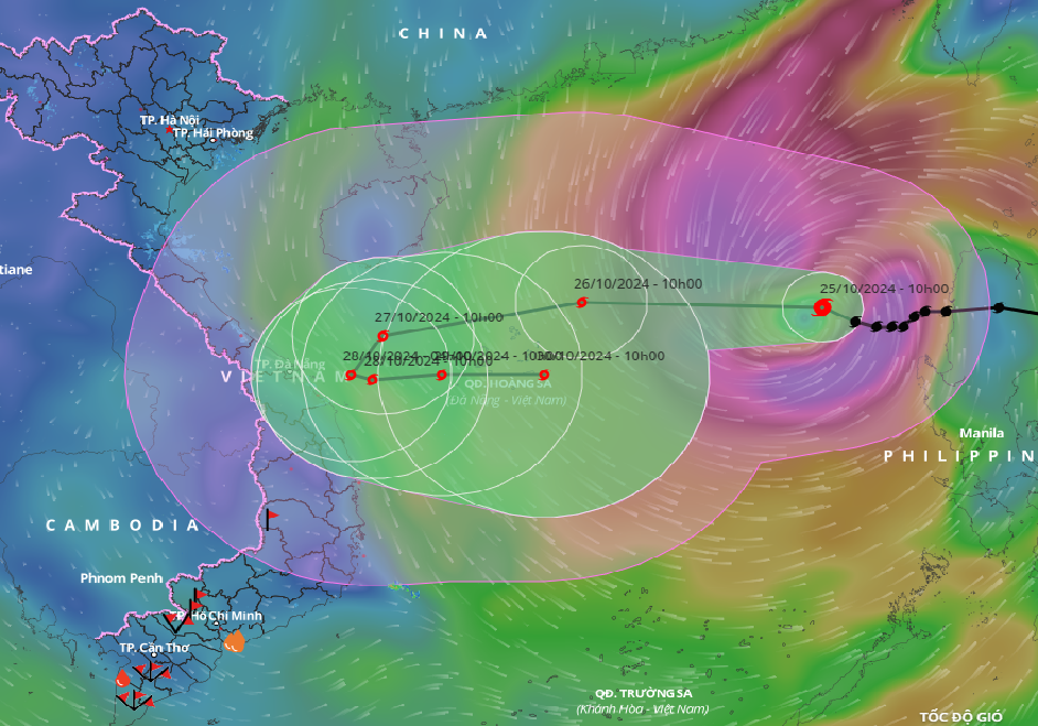
According to the National Center for Hydro-Meteorological Forecasting, as of 10 a.m. today (October 25), the storm's center was positioned over the eastern waters of the northern East Sea. The strongest winds near the center were Category 10 (89-102 km/h), with gusts reaching Category 12. The storm is currently moving west-northwest at about 15 km/h.
By 10 a.m. on October 26, the storm's center is expected to be in the northern East Sea, approximately 160 km northeast of the Hoang Sa archipelago. The strongest winds near the center will be Category 11-12, with gusts up to Category 15. The storm will move westward at a speed of 20 km/h.
By 10 a.m. on October 27, the storm will be located west of the Hoang Sa archipelago, about 200 km northeast of Quang Tri - Quang Ngai. The strongest winds near the center will be Category 11, with gusts up to Category 14, moving west-southwest at a speed of 15 km/h.
By 10 a.m. on October 28, the storm's center will be over the offshore waters of central Vietnam. The strongest winds near the center will be Category 10, with gusts reaching Category 12. The storm will shift southwest, then southeast, moving at around 5-10 km/h.
In the following 72 to 120 hours, the storm is expected to move mainly eastward, at a speed of 5-10 km/h, with its intensity gradually weakening.
Earlier today, during a meeting to address Typhoon Trami (Tra Mi) organized by the Department of Dyke Management and Natural Disaster Prevention under the Ministry of Agriculture and Rural Development, Mr. Nguyen Van Huong, Head of the Weather Forecasting Department at the National Center for Hydro-Meteorological Forecasting, provided insights into the storm's complex movement.
Over the next 24 hours, Trami is expected to move westward and could reach a peak intensity of Category 12, with gusts up to Category 15. Upon reaching the northern Hoang Sa region, the storm may weaken due to the influence of cold air, reducing its intensity to Category 10-11.
Mr. Huong explained that after passing the Hoang Sa archipelago (beyond the 110th meridian east), the storm may change direction, veering back out to sea due to a developing tropical depression east of the Philippines, which could strengthen into a storm.
The interaction of these twin storm systems is causing Typhoon Trami to move outward and weaken. However, the storm's strong winds extend over a wide area, with convective cloud bands skewed westward, making the northern and central East Sea the primary zones affected by strong winds.
With the storm's projected path, strong winds of Category 6-7 are expected off the central coast by tomorrow afternoon (October 26). As the storm approaches, wind speeds could increase to Category 8-9, and similar conditions are expected around Ly Son Island.
Notably, with cloud systems leaning westward, Typhoon Trami is likely to bring heavy rains across central Vietnam from the evening of October 26 to October 29, particularly affecting regions from Ha Tinh to Binh Dinh and Phu Yen. Areas such as Quang Tri to Quang Nam, Kon Tum, and Gia Lai could see rainfall amounts reaching 200-300 mm, with the possibility of localized intense downpours.
Due to Typhoon Trami, the northern East Sea will experience strong winds of Category 8-9, with areas near the storm's path seeing winds of Category 10-12 (89-133 km/h) and gusts up to Category 15. Waves could reach heights of 5-7 meters, with regions near the storm center seeing waves of 7-9 meters, resulting in extremely rough seas.
Boats operating in the hazardous areas, especially around the Hoang Sa archipelago, could face thunderstorms, whirlwinds, strong winds, and high waves.
Experts emphasize that late-season storms often behave unpredictably, urging residents to stay updated with regular forecasts to monitor developments.
Bao Anh