Typhoon Ragasa is expected to reach super typhoon status before entering the East Sea around September 23. Northern waters of the East Sea, including the Hoang Sa (Paracel) archipelago, are forecast to experience extremely rough seas with waves exceeding 10 meters.
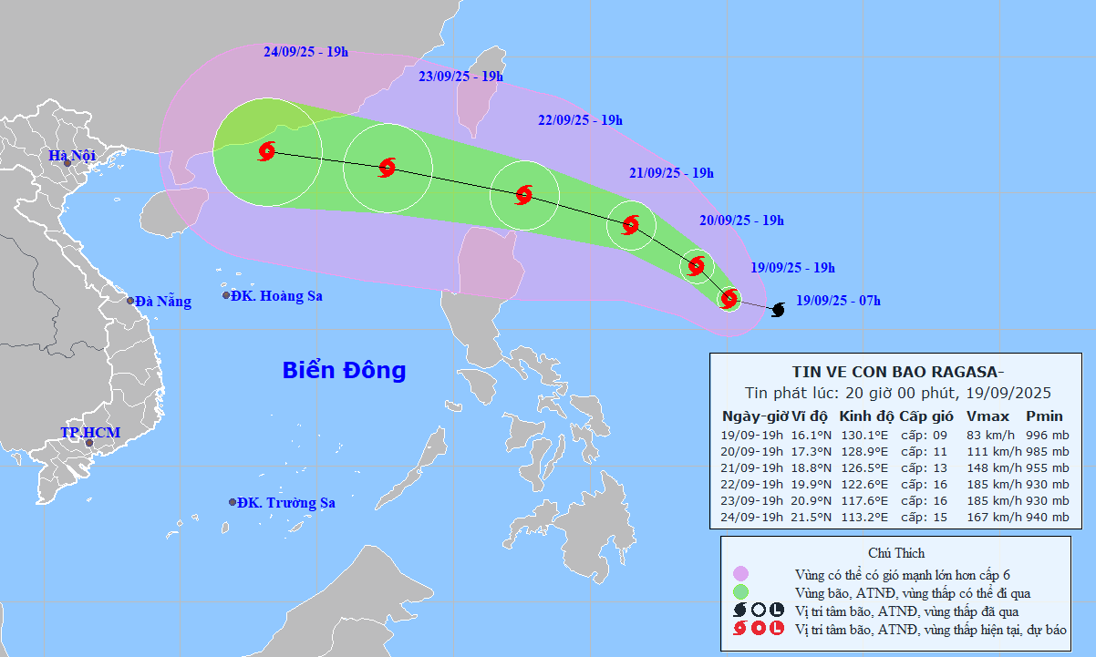
According to the National Center for Hydro-Meteorological Forecasting, as of 7 p.m. on September 19, the eye of Typhoon Ragasa was located at approximately 16.1 degrees North latitude and 130.1 degrees East longitude, about 820 km east of Luzon Island in the Philippines. The strongest winds near the storm’s center reached level 9 (75-88 km/h), with gusts at level 11. The typhoon is moving west-northwest at around 15 km/h.
In the next 24 hours, Ragasa is expected to shift northwestward at about 10 km/h and intensify further. By 7 p.m. on September 20, it will be approximately 680 km east of Luzon, with its strength increasing to level 11, gusting to level 13.
In the following 24 hours, Ragasa will continue on a northwest trajectory at 10-15 km/h, further intensifying. By 7 p.m. on September 21, it will be about 480 km east of Luzon with a projected strength of level 13, gusting to level 16.
Another 24 hours later, the typhoon will move west-northwest at a faster speed of 15-20 km/h and continue to strengthen. By 7 p.m. on September 22, the center will be near 19.9 degrees North and 122.6 degrees East, about 150 km northeast of Luzon. At that point, it is forecast to reach super typhoon intensity, with winds at level 15-16 and gusts exceeding level 17.
From 72 to 120 hours from now, Ragasa will mainly continue moving west-northwest at 20-25 km/h, with little change in intensity.
Experts anticipate that by around September 23, Ragasa will enter the East Sea, becoming the ninth named storm of 2025. It is expected to have a direct impact on Vietnam’s mainland between September 24 and 26.
Due to the influence of Ragasa’s circulation, from the afternoon and evening of September 22, the eastern part of the northern East Sea will see increasing winds at levels 6-7, rising to levels 8-9.
From September 23 onward, the northern East Sea (including the Hoang Sa archipelago) could be hit by Ragasa with maximum sustained winds reaching level 14-16, gusting beyond level 17. Wave heights may exceed 10 meters, and sea conditions will be extremely dangerous, particularly for vessels operating in the northern and central parts of the East Sea.
The National Center for Hydro-Meteorological Forecasting is closely monitoring the development of Typhoon Ragasa.
In a related update on Typhoon Mitag (Storm No. 8), as of 7 p.m. on September 19, its center was located inland in southern Guangdong province, China, with maximum winds at level 8 (62-74 km/h), gusting to level 10. The storm is moving northwest at 5-10 km/h.
Over the next 12 hours, Mitag is expected to move west-northwest at 10-15 km/h, gradually weakening into a tropical depression and then a low-pressure area.
Proactive measures urged as Ragasa nears the East Sea
The National Civil Defense Steering Committee has issued a directive to the People's Committees of coastal provinces and cities from Quang Ninh to Lam Dong, urging them to proactively respond to Typhoon Ragasa, which is moving toward the East Sea.
The directive asks local authorities to closely monitor warnings, forecasts, and storm developments. Timely information must be provided to captains, vessel owners, and fishermen at sea so they can make necessary adjustments to their operations and ensure the safety of lives and property. Communication systems must be maintained to handle emergencies promptly.
Localities are also required to prepare rescue and relief forces and equipment, maintain strict emergency duty rotations, and report regularly to the National Civil Defense Steering Committee under the Ministry of Agriculture and Environment.
Bao Anh