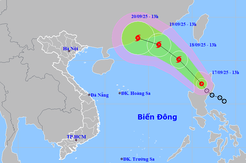
Over the next 24 hours, the system is expected to maintain its northwestward track while increasing speed to 15-20 km/h, entering the East Sea and potentially strengthening into a tropical storm.
By 1:00 p.m. on September 18, the storm’s center will be located in the northeastern waters of the North East Sea, with maximum sustained winds at level 8 and gusts up to level 10. If upgraded, this would be the 8th named storm of the 2025 typhoon season over the East Sea.
The system is projected to continue moving northwestward at around 15 km/h, with further intensification. By 1:00 p.m. on September 19, the storm’s center will be situated approximately 250 km southeast of Hong Kong (China). Wind intensity is expected to increase to level 8-9, with gusts at level 11.
In the following 48 to 72 hours, the storm will continue on a west-northwest path at around 10 km/h, with wind strength expected to remain relatively stable.
Rough seas and strong winds expected
Due to the tropical depression and its likely transition into a storm, from late this afternoon, the northeastern area of the North East Sea will experience increasing wind speeds at level 6-7, with gusts at level 9. Areas near the storm center may experience wind strength up to level 8, gusting to level 10, with sea waves reaching 2.5 to 4.5 meters in height.
The sea will become increasingly rough, and vessels operating in these hazardous zones are at risk from thunderstorms, whirlwinds, high winds, and large waves.
Bao Anh
