 Vietnamnet.vn

 Podcast



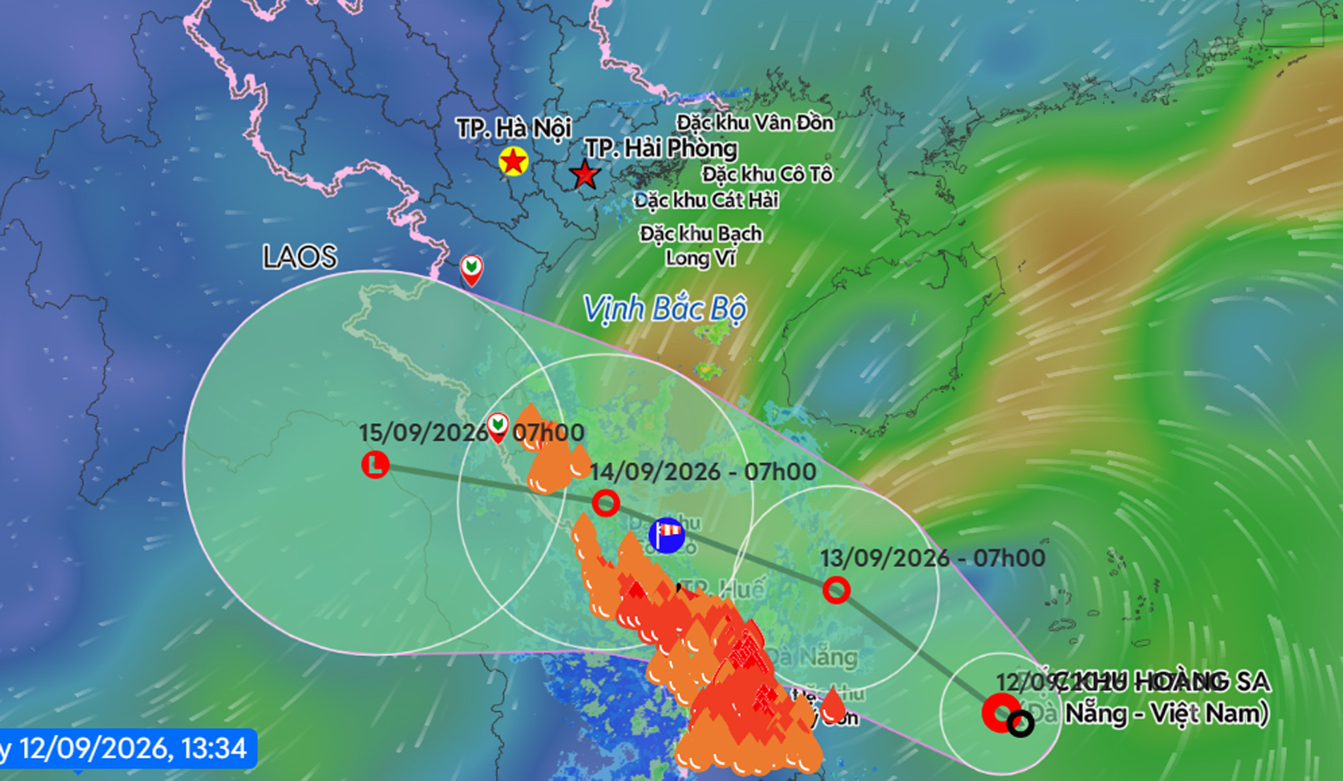
Tropical depression heads toward Quang Tri-Hue waters
According to Vietnam’s National Center for Hydro-Meteorological Forecasting, a low-pressure area over waters southwest of the Hoang Sa archipelago strengthened into a tropical depression early on September 12.
At 1 p.m., its centre was at about 15.6 degrees north latitude and 110.3 degrees east longitude, around 150km southwest of Hoang Sa and 230km southeast of Da Nang.
Maximum sustained winds near the centre were 39-49kph, with gusts reaching level 8 on Vietnam’s wind scale. The system was moving northwest at about 10kph.
Over the following 24 hours, the tropical depression was forecast to continue northwest at around 10kph.
By 1 p.m. on September 13, its centre is expected to be over waters off Quang Tri and Hue, around 130km east of Quang Tri and 90km northeast of Hue. Winds are forecast to remain at 39-49kph, with stronger gusts.
During the next 24 hours, the system is expected to turn west-northwest and accelerate to 10-15kph before gradually weakening into a low-pressure area.
By 1 p.m. on September 14, its centre is forecast to be over central Laos.
The tropical depression is expected to bring strong winds and rough seas to waters west of Hoang Sa and from Ha Tinh to Quang Ngai. Waves could reach 2-4 metres.
Vessels in affected waters face the risk of thunderstorms, tornadoes, strong winds and high waves.
Days of heavy rain forecast for central Vietnam
The combination of the tropical depression, an intertropical convergence zone and other atmospheric conditions is expected to produce a complicated spell of heavy rain across central Vietnam in the coming days.
Areas from southern Quang Tri to Quang Ngai recorded moderate to heavy rain on September 12, while Hue and Da Nang experienced heavy to extremely heavy downpours.
Between 7 a.m. and 3 p.m., rainfall exceeded 270mm in some places. Bach Ma Peak in Hue recorded 303.8mm, while Cau Lau in Da Nang received 273mm.
From the evening of September 12 through September 13, areas from Ha Tinh to northern Quang Tri and eastern Quang Ngai are forecast to receive 50-100mm of rain, with isolated totals exceeding 180mm.
Southern Quang Tri through Da Nang could see particularly intense rainfall of 100-200mm, with more than 350mm possible in some locations.
On September 13, the heaviest rain is expected to gradually shift northward.
Thanh Hoa and Nghe An are forecast to receive 20-40mm, with isolated rainfall exceeding 100mm.
From the night of September 13 through September 14, areas from Thanh Hoa to Quang Tri are expected to receive heavy to extremely heavy rain of 100-200mm, with isolated totals above 350mm.
Vietnam’s northern midlands and Red River Delta, southern Son La and Phu Tho, as well as Hue and Da Nang, could receive 30-60mm, with more than 100mm possible in some places.
Forecasters warned that rainfall could exceed 100mm within just three hours.
During the night of September 12 and September 13, eastern areas from Gia Lai to Lam Dong, the Central Highlands and southern Vietnam are also forecast to receive 20-40mm of rain, with isolated totals exceeding 80mm.
From the night of September 14 through September 15, moderate to heavy rain and thunderstorms are forecast across the northern midlands and Red River Delta, southern Son La, Phu Tho, Tuyen Quang and Lao Cai, as well as from Thanh Hoa to northern Nghe An and Quang Tri.
Rainfall in these areas is forecast at 30-60mm, with isolated totals exceeding 100mm.
Southern Nghe An and Ha Tinh could receive 70-150mm of rain, with more than 200mm possible in some locations.
Heavy rain in affected regions could persist until the morning of September 16.
Weather authorities warned that thunderstorms could bring tornadoes, lightning, hail and strong wind gusts.
The prolonged heavy rain also raises the risk of flooding in low-lying areas, cities and industrial zones, as well as flash floods along small rivers and streams and landslides on steep slopes.
Bao Anh
.svg)
