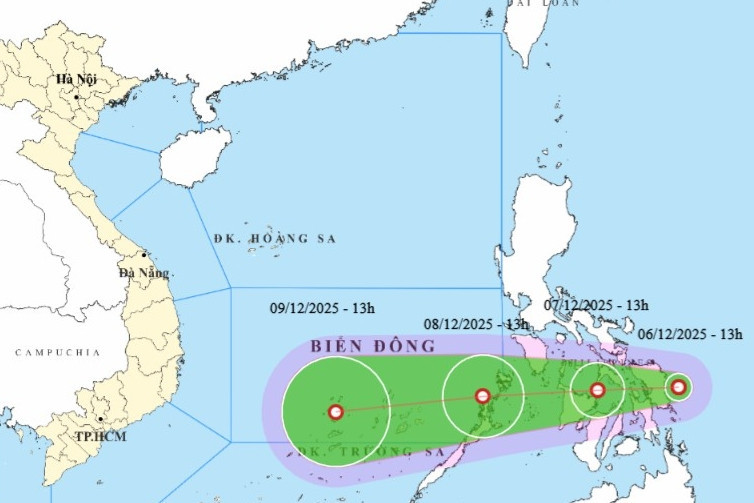
According to the National Center for Hydro-Meteorological Forecasting, as of 7 a.m. on December 7, the storm's center was located at approximately 12°N latitude and 124.3°E longitude, over the central Philippines. Winds near the center reached level 6 (39–49 km/h), with gusts up to level 8.
The system is moving westward at a speed of about 15 km/h.
Over the next 24 hours, the tropical depression is forecast to shift to a west-southwest direction at 15–20 km/h. By 7 a.m. on December 8, its center will be over the northeastern sea of Palawan Island (Philippines), still sustaining winds at level 6, gusting at level 8.
In the following 24 hours, the depression is expected to maintain its west-southwest track, accelerating to 20 km/h and entering the East Sea. By 7 a.m. on December 9, the storm will be located northeast of the Truong Sa (Spratly) Archipelago, about 240 km east-southeast of Song Tu Tay Island, with intensity unchanged at level 6 and gusts up to level 8.
Between 48 and 72 hours from now, the tropical depression will continue moving west-southwest at 20–25 km/h and begin to weaken gradually.
Due to its influence, from the morning of December 8, the southeastern part of the central East Sea (including the northeast waters of the Truong Sa Archipelago) will experience rough seas with wind levels reaching 6, gusts up to 8, and waves of 2 to 4 meters.
Maritime vessels operating in this hazardous area are at risk of encountering thunderstorms, squalls, strong winds, and high waves.
Bao Anh