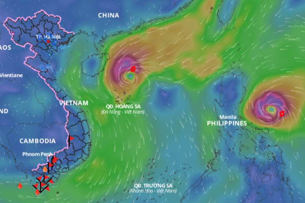
Typhoon Yinxing (Storm No. 7) is showing signs of rapid weakening, while Typhoon Toraji is expected to enter the East Sea as Storm No. 8. The interaction between these two storms has created a “Fujiwhara effect,” causing Typhoon Toraji to push Storm No. 7 further southward.
Nguyen Van Huong, head of the Weather Forecast Department at the National Center for Hydro-Meteorological Forecasting, shared updates on Storm No. 7’s progress and the overall outlook for storms in the East Sea over the coming days.
On the morning of November 4, a tropical depression east of the Philippines intensified into a storm named Yinxing (the 22nd storm in the Northwest Pacific region). By the afternoon of November 7, Yinxing made landfall in the eastern Philippines, and early the next morning, it entered the East Sea, becoming Storm No. 7.

Since entering the East Sea, Typhoon Yinxing has maintained its strength at Level 14, with gusts reaching Level 17. By the afternoon of November 9, the storm intensified further to Levels 14-15 before stabilizing and then shifting southward, with its intensity decreasing significantly by the morning of November 10.
According to Mr. Huong, environmental conditions are influencing both the trajectory and intensity of Storm No. 7.
Firstly, sea surface temperatures in the area west of the Paracel Islands are below optimal levels (under 26°C), limiting the energy available to sustain the storm and gradually weakening it. Secondly, cold, dry air has reduced atmospheric moisture from the surface up to an altitude of 1,500 meters, inhibiting cloud formation within the storm.
Currently, a new storm named Toraji is developing east of the Philippines. As of the morning of November 11, Toraji will move into the region east of Luzon Island, maintaining a distance of 1,200-1,400 km from Yinxing, which is close enough to create a Fujiwhara interaction between the two. Toraji is expected to pull Yinxing southward as a result.
According to Mr. Huong’s 11 a.m. forecast on November 10, over the next 24-48 hours, Storm No. 7 will continue moving southwest and will weaken rapidly to below Level 10 due to suboptimal sea temperatures and low humidity levels.
Because of Storm No. 7, strong winds of Level 7-9 are expected in the western part of the northern East Sea, with areas near the storm’s center experiencing winds of Level 10-13 and gusts reaching Level 16. Wave heights are forecast at 4-6 meters, with waves near the center of the storm reaching 6-8 meters, creating rough sea conditions.
From early tomorrow morning, coastal areas from Quang Tri to Quang Ngai will experience winds at Levels 6-7, with areas close to the storm center experiencing winds at Level 8, gusting to Level 10, and wave heights of 2-4 meters, increasing to 3-5 meters near the storm center. Vessels operating in these hazardous areas are at risk of thunderstorms, squalls, strong winds, and high waves.
On land, due to the effects of Storm No. 7’s outer bands, moderate rainfall is expected from tomorrow evening through November 12 in the Central and South-Central regions, though extreme rainfall leading to significant flooding in rivers is unlikely.
However, Mr. Huong advises that this forecast is based on current data, and residents, especially in coastal areas from Quang Tri to Quang Ngai, should monitor the storm closely and prepare response plans to mitigate risks.
Mr. Huong also noted that in addition to the two storms, a tropical depression is currently active east of the Philippines. Toraji is expected to enter the East Sea between the late afternoon and evening of November 11, which will bring a new storm, Storm No. 8, following Storm No. 7.
The influence of Storm No. 7, followed by Storm No. 8, is expected to result in prolonged adverse weather in the northern and central East Sea, with strong winds, high waves, and rough sea conditions.
The center will continue monitoring and providing updates on storm developments.
In response to the severe weather, the Minister of Agriculture and Rural Development has issued a directive to the People’s Committees of coastal provinces from Quang Ninh to Binh Thuan, urging proactive measures to mitigate the impact of these storms.
Bao Anh