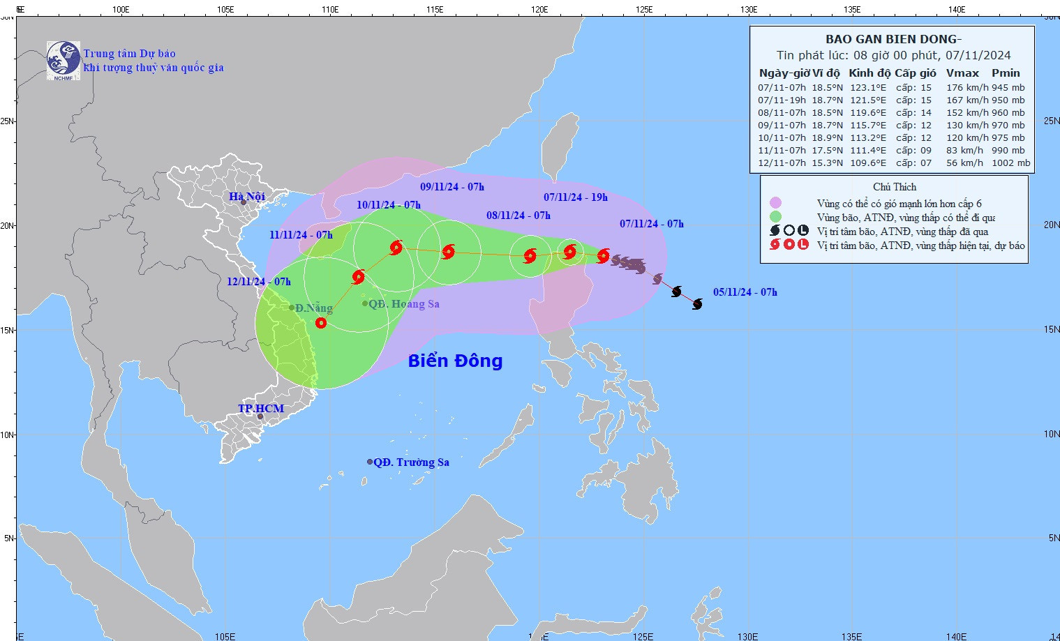
This storm is forecast to continue moving west-northwest at a speed of 5-10 km/h, according to the National Center for Hydro-Meteorological Forecasting. Upon entering the East Sea, Yinxing will become Vietnam's seventh storm of 2024.
Projected path of Typhoon Yinxing in the coming days:
- November 8, 7 a.m.: Yinxing is expected to enter the East Sea, traveling west at around 15 km/h, with its center located at approximately 18.5°N, 119.6°E, just east of the northern East Sea. Wind intensity is projected to be Category 14, with gusts reaching Category 16. The storm poses significant risks for the area between latitudes 17.0°N and 21.0°N and east of longitude 118.0°E.
- November 9, 7 a.m.: Moving west-northwest at 15-20 km/h, Yinxing will approach 18.7°N, 115.7°E, east of the northern East Sea and approximately 430 km northeast of the Paracel Islands, with maximum sustained winds at Category 12 and gusts up to Category 14.
- November 10, 7 a.m.: Expected to move west-northwest at around 10 km/h, the storm will be at 18.9°N, 113.2°E, approximately 260 km north-northeast of the Paracel Islands, with winds still at Category 12 and gusts up to Category 14.
After the 72-hour mark, Typhoon Yinxing is expected to shift to a southwesterly path, weakening gradually while maintaining a speed of 10-15 km/h.
Typhoon Yinxing will bring strong winds and high waves to the northern East Sea. Wind speeds in affected areas are expected to reach Categories 6-7, rising to Categories 8-10 overnight, with areas near the storm center seeing winds of Categories 12-14 and gusts up to Category 16.
Waves could range from 4-6 meters high, peaking at 6-8 meters near the storm’s center, causing extreme ocean conditions.
All vessels in these hazardous zones are advised to prepare for severe weather, including thunderstorms, strong winds, and high waves.
The Ministry of Agriculture and Rural Development (MARD) has issued an emergency directive in response to Typhoon Yinxing’s approach. The Minister has called on various agencies, as well as the Chairpersons of coastal provinces from Quang Ninh to Binh Thuan, to take the following actions:
1. Closely monitor the storm: Track Typhoon Yinxing’s progress, manage outbound vessels, conduct vessel counts, and ensure that captains and boat owners are informed of the storm’s position and projected path to avoid hazardous areas.
2. Address recent flooding impacts in central provinces: Coastal and central provinces should prioritize rapid recovery from recent flooding, checking dam and reservoir safety, and managing water levels to anticipate incoming storms.
3. Prepare for rescue operations: Mobilize personnel and equipment to be ready for search and rescue operations as needed.
4. Ensure coordinated response efforts: Government ministries and agencies are directed to work with local authorities, reviewing emergency response plans and mobilizing resources as required to effectively handle potential storm and flood impacts.
5. Increase public awareness: National and regional media outlets, including Vietnam Television (VTV), Radio the Voice of Vietnam, the Vietnam News Agency, and coastal radio systems, are instructed to keep citizens informed of Typhoon Yinxing’s developments and anticipated weather conditions.
6. Maintain round-the-clock vigilance: Maintain 24-hour monitoring, with regular updates provided to MARD via the Department of Dyke Management and Natural Disaster Prevention and Control.
Ly Dao
