According to the National Center for Hydro-Meteorological Forecasting, as of 7 a.m. on November 3, the storm's center was located over the eastern waters of central Philippines. Wind speeds near the center reached level 11 (89–102 km/h), with gusts at level 15 - an increase of two levels from the previous day.
Kalmaegi is currently moving west-southwest at about 25 km/h.
In the next 24 hours, the storm is expected to move mainly westward at about 20 km/h and continue strengthening. By 7 a.m. on November 4, the storm's center will remain over the central Philippines with winds reaching level 12 (118–133 km/h) and gusts at level 15.
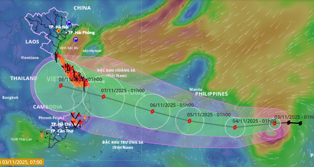
In the following 24 hours, Kalmaegi is forecast to shift northwestward at 20–25 km/h. By early November 5, it is likely to enter the East Sea, becoming the 13th typhoon of 2025.
Once over the East Sea, Kalmaegi is projected to maintain its direction and intensity. By 7 a.m. that day, its center will be over the eastern waters of the central East Sea, with sustained winds increasing to level 13 and gusts at level 15.
The typhoon will continue moving northwestward at 20 km/h. By 7 a.m. on November 6, its center will be over the central East Sea, approximately 430 km southeast of the Gia Lai coast. Winds near the center could reach level 14 with gusts at level 17.
The typhoon is expected to hold this strength before gradually weakening.
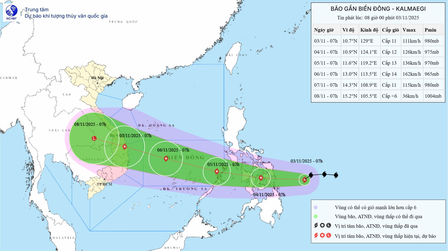
Earlier forecasts indicated that Kalmaegi may make landfall in Vietnam around November 7, with the region from Da Nang to Khanh Hoa expected to be most affected.
Kalmaegi may bring strong winds and heavy rains to central and southern central provinces and the Central Highlands from the night of November 6 to 9. Forecasters emphasize that the storm’s path and intensity are still subject to change due to large-scale environmental factors, and local authorities and residents are advised to stay updated.
Due to the storm’s influence, from the afternoon of November 4, the eastern part of the central East Sea will experience increasing wind speeds of level 6–7, escalating to level 8–9, and up to level 10–12 near the storm's center, with gusts reaching level 14–15 and wave heights of 5–7 meters.
From November 5 to 6, the central East Sea (including the Spratly Islands) and offshore waters from Da Nang to Khanh Hoa may be impacted by strong winds at level 12–14, with gusts above level 17 and waves as high as 8–10 meters.
All vessels and offshore structures in the affected areas will face severe conditions, including thunderstorms, tornadoes, high winds, and large waves.
Current forecasts suggest the southern central coast is most likely to experience direct impacts as the storm approaches, with widespread heavy rain expected from November 6 to 8.
In central Vietnam, where recent downpours have saturated the soil with rainfall in the thousands of millimeters, a strong landfalling storm could trigger flash floods and landslides.
Water levels on many rivers remain high. Additional rainfall could cause them to rise again, leading to widespread and severe flooding.
Bao Anh