Typhoon Koto, the 15th storm to form in the region this year, has intensified to Category 12 with gusts up to Category 15. At the same time, the storm is slowing and repeatedly changing direction. Forecasts suggest it will encounter a cold air mass and linger near longitudes 112-114 for the next three to four days.
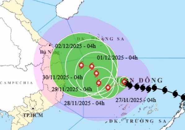
According to the National Center for Hydro-Meteorological Forecasting, as of 4 a.m. on November 27, the eye of Typhoon Koto was located about 190 km north of Song Tu Tay Island. The strongest winds near the center of the storm were blowing at 118–133 km/h, with gusts reaching up to 167 km/h. The typhoon was moving west-northwest at a speed of about 15 km/h.
This means that in the past 24 hours, Koto’s wind strength jumped four levels while its speed slightly decreased.
Forecasts show that over the next 24 hours, the storm will continue to slow down and shift direction frequently. Between the 24th and 48th hour mark, the storm is expected to gradually weaken due to interaction with cold air.
Specifically, during today and tonight, Koto will move west-southwest at 5–10 km/h, with little change in strength. By 4 a.m. tomorrow, the storm’s center will be over the western part of the central South China Sea, about 190 km northwest of Song Tu Tay Island. It will maintain Category 12 intensity with gusts up to Category 15.
Over the next 24 hours, Koto will shift toward the west-northwest, then to the northwest, moving at about 5 km/h and gradually weakening. By 4 a.m. on November 29, it will remain over the central western East Sea, with its strength reduced to Category 11 (103–117 km/h), gusting to Category 14.
In the following 24 hours, Koto will continue veering north-northwest at a very slow pace of 3–5 km/h and continue weakening. By 4 a.m. on November 30, it is expected to remain over the western part of the central South China Sea, with wind speeds down to Category 10 (89–102 km/h), gusting to Category 13.
From 72 to 120 hours ahead, the storm is forecast to move slowly north-northwest, then turn west-northwest, maintaining a speed of 3–5 km/h while continuing to weaken.
Hoang Phuc Lam, Deputy Director of the National Center for Hydro-Meteorological Forecasting, said that Typhoon Koto’s interaction with the incoming cold front makes its trajectory and strength highly complex.
The storm's slowdown is due to a weakening subtropical high-pressure system that typically guides storms. As Koto reaches longitudes 112–113, it is expected to veer northward.
Today, the storm continues to travel over warm waters of about 27–28°C. Once it hits the colder sea area near longitudes 112–113, the lower water temperature is expected to reduce the storm’s strength.
Meteorologists have outlined two possible scenarios for Typhoon Koto.
In the first and most likely scenario (about 80% probability), the typhoon will curve northward toward the northwestern seas of the Truong Sa (Spratly) Archipelago. It will weaken into a tropical depression about 500 km off the coast of Gia Lai–Khanh Hoa and drift toward central Vietnam. In this case, strong winds are unlikely to affect the mainland, though moderate rainfall under 50 mm/day is expected, with coastal areas potentially receiving 50–100 mm/day.
The second scenario (20% probability) predicts that Koto will continue westward without changing direction, heading straight toward Gia Lai–Khanh Hoa. Under this path, it could bring strong winds over Category 6 to inland areas, and rainfall ranging from 100 to 250 mm is possible in coastal areas from Da Nang to Lam Dong between November 29 and December 1.
Current forecast models vary significantly regarding both the storm’s intensity and trajectory. The National Center for Hydro-Meteorological Forecasting is closely monitoring developments and the factors influencing Koto’s path to provide timely updates in future forecasts.
For now, the effects of Typhoon Koto are already being felt in the central South China Sea, including the northern waters of the Truong Sa Archipelago. Wind speeds range from Category 7 to 9, with gusts reaching Category 15 near the storm center. Waves are 4–6 meters high, and up to 9 meters near the storm’s core, making for extremely rough seas.
All vessels operating in these dangerous zones are at risk of thunderstorms, gales, and large waves.
Bao Anh