 |
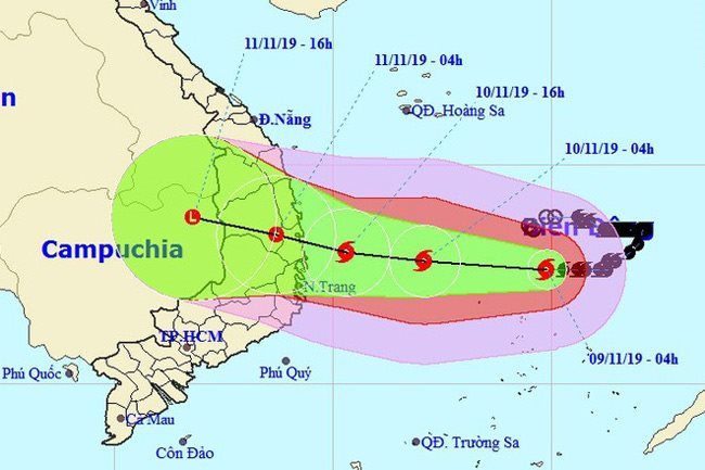
As of 4am this morning, the storm, the sixth and likely the strongest to hit the East Sea so far this year, was located at about 300km off coast the provinces from Quang Ngai to Khanh Hoa, packing winds of 90- 115km per hour near its eye (scale 10-11), shock at scale 13. Radius of strong wind from scale 6, shock from scale 8 or above, was about 150km from the storm’s centre.
In the next 24 hours, the storm is predicted to move in the West-Northwest direction at a speed of 10-15km per hour, hitting the mainland of provinces from Quang Ngai to Khanh Hoa with scale 8-9 winds, shock at scale 11, and then weakening into a tropical depression.
As of 4am tomorrow, the centre of the tropical depression is forecast at about 13.2 degrees north latitude and 108.8 degrees east longitude, in the mainland of South Central and Central Highlands provinces. Maximum wind speed near the storm’s eye is scale 7 (50-60km per hour), shock at scale 9.
As of November 12 morning, the tropical depression continues to move further inland in the same direction and at the same speed before weakening into a depression.
Due to the impacts of Typhoon Nakri and cold air, strong winds and rough sea are expected on the waters off localities from Da Nang to Khanh Hoa, while heavy rains, flood and landslides, are also warned for provinces from Thue Thien-Hue to Ninh Thuan and the Central Highlands region.
Earlier on Nov. 9, Deputy Prime Minister Trinh Dinh Dung inspected and directed response work to Typhoon Nakri in the central province of Binh Dinh.

Deputy PM Trinh Dinh Dung (in white) inspects response work to the storm in Binh Dinh province.
He urged local leaders to review and inform boats to seek safe shelters and thoroughly evacuate the people from dangerous areas.
Drastic and proactive measures must be taken aiming to minimise the damage caused by the storm when it hits the mainland, especially ensuring the safety of the people and assets of both locals and the State, the deputy PM requested. Nhan Dan
 Typhoon Nakri is predicted to land in the provinces of Quang Ngai, Binh Dinh, Phu Yen and Khanh Hoa later today with a strong scale 8-9 wind, shock at scale 11, and then weaken into a tropical depression.