 Vietnamnet.vn

 Podcast



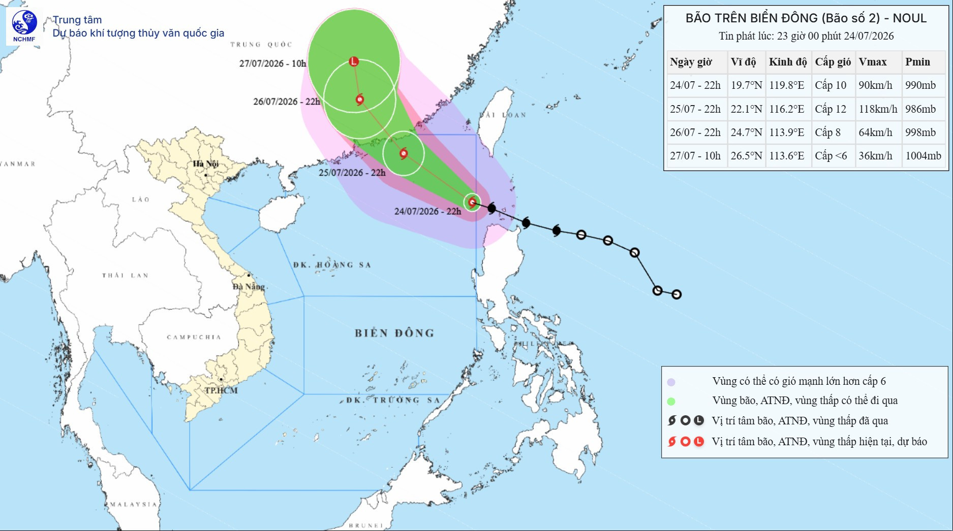
According to the National Center for Hydrometeorological Forecasting, Noul officially moved into the East Sea on the night of July 24, becoming the second storm of the year.
At 10 p.m., the center of the storm was over the northeastern waters of the northern East Sea, about 710 km southeast of Hong Kong, China.
Maximum sustained winds near the center reached force 10, or 89-102 km/h, with gusts at force 12. The storm was moving west-northwest at about 25 km/h.
Under the current forecast, Noul will continue moving mainly west-northwest, with a probability of more than 80% that it will make landfall in Guangdong province, China. It is considered unlikely to directly affect Vietnam's mainland.
Over the next 24 hours, the storm is expected to maintain a speed of 20-25 km/h.
By 10 p.m. on July 25, its center is forecast to remain over the northeastern waters of the northern East Sea, about 230 km east-southeast of Hong Kong.
Noul could strengthen to force 11-12, with gusts reaching force 14. The natural disaster risk level is 3 for the northeastern waters of the northern East Sea.
Noul expected to weaken after landfall in Guangdong
Over the following 24 hours, the storm is forecast to maintain its west-northwest track at 15-20 km/h.
By 10 p.m. on July 26, its center is expected to be over land in Guangdong province, China, with winds weakening to force 8 and gusts at force 10.
The natural disaster risk level remains at 3 for the northeastern waters of the northern East Sea.
Noul will then move north-northwest at 15-20 km/h.
By 10 a.m. on July 27, the storm center is forecast to remain over Guangdong province. It is expected to weaken gradually into a tropical depression and later into a low-pressure area, with winds below force 6.
Noul is forecast to bring strong winds of force 6-7 to the northeastern waters of the northern East Sea, increasing later to force 8-10, with waves of 4-6 meters.
Near the storm center, winds could reach force 11-12 with gusts at force 14, while waves may rise to 5-7 meters. Seas will be extremely rough.
Vessels operating in the affected areas could face thunderstorms, tornadoes, strong winds and high waves.
Bao Anh
.svg)
